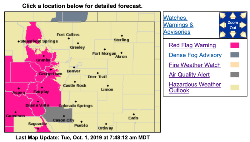
Respite is on the way, per Chief Meteorologist Steve Hamilton, but fire danger remains high today for Park and Summit Counties.
Mountain Weather Forecasts for Fairplay, Alma, Jefferson/Como, Bailey, Pine, Conifer, Evergreen, and Morrison:
mymountaintown.com/expert-local-weather
Red Flag Warning
URGENT - FIRE WEATHER MESSAGE
National Weather Service Denver/Boulder CO
254 AM MDT Tue Oct 1 2019
...FIRE DANGER REMAINS HIGH ACROSS THE MOUNTAINS AND HIGH VALLEYS...
.Dry and gusty southwest winds can be expected again today, with the highest fire danger during the strongest winds from this afternoon until about sunset.
Fire danger will remain elevated much of this week, with occasional bouts of gusty winds, low humidity, and lack of meaningful precipitation.
COZ213-214-011800-
/O.CON.KBOU.FW.W.0010.191001T1800Z-191002T0100Z/
Grand and
Summit Counties Below 9000 Feet-
Central and Southeast Park County-
254 AM MDT Tue Oct 1 2019
...
RED FLAG WARNING REMAINS IN EFFECT FROM NOON TODAY TO 7 PM MDT THIS EVENING FOR WIND AND LOW RELATIVE HUMIDITY FOR MIDDLE PARK AND SOUTH PARK...
* Affected Area...Fire Weather Zones 213 and 214.
* Winds...Southwest 15 to 20 mph with gusts up to 35 mph.
* Timing...This afternoon, then easing at sunset.
* Relative Humidity...As low as 9 percent.
* Impacts...Conditions will be favorable for the rapid ignition, growth, and spread of fires.
PRECAUTIONARY/PREPAREDNESS ACTIONS...
A Red Flag Warning means that critical fire weather conditions are either occurring now....or will shortly. A combination of strong winds...low relative humidity...and warm temperatures can contribute to extreme fire behavior.
************************************************
URGENT - FIRE WEATHER MESSAGE
National Weather Service Denver/Boulder CO
254 AM MDT Tue Oct 1 2019
...FIRE DANGER REMAINS HIGH ACROSS THE MOUNTAINS AND HIGH VALLEYS...
.Dry and gusty southwest winds can be expected again today, with the highest fire danger during the strongest winds from this afternoon until about sunset.
Fire danger will remain elevated much of this week, with occasional bouts of gusty winds, low humidity, and lack of meaningful precipitation.
COZ211-212-011800-
/O.EXA.KBOU.FW.W.0010.191001T1800Z-191002T0100Z/
Jackson County Below 9000 Feet-
South and Southeast Grand/West Central and Southwest Boulder/
Gilpin/Clear Creek/Summit/North and West Park Counties Above 9000 Feet-
254 AM MDT Tue Oct 1 2019
...
RED FLAG WARNING IN EFFECT FROM NOON TODAY TO 7 PM MDT THIS EVENING FOR WIND AND LOW RELATIVE HUMIDITY FOR NORTH PARK AND MOST OF SUMMIT COUNTY...
The National Weather Service in Denver has issued a Red Flag Warning FOR WIND AND LOW RELATIVE HUMIDITY, which is in effect from noon today to 7 PM MDT this evening.
* Affected Area...Fire Weather Zones 211 and 212.
* Winds...Southwest 15 to 20 mph with gusts up to 35 mph.
* Timing...This afternoon, then easing at sunset.
* Relative Humidity...As low as 9 percent.
* Impacts...Conditions will be favorable for the rapid ignition, growth, and spread of fires.