- Posts: 9766
- Thank you received: 221
- Forum
- Life Up the Hill
- Scanner & Emergency Info, Weather Forecasts
- MMT Weather Forecast Oct 8: Red Flag Warning Wednesday, Snow Thursday
MMT Weather Forecast Oct 8: Red Flag Warning Wednesday, Snow Thursday
- MountainTownAlerts
-
 Topic Author
- Mountain Legend
-

Less
More
08 Oct 2019 21:02 #1
by MountainTownAlerts
MMT Weather Forecast Oct 8: Red Flag Warning Wednesday, Snow Thursday was created by MountainTownAlerts
From Chief Meteorologist Steve Hamilton:
Red Flag Warning Wednesday... Snow Thursday...
Extreme changes to our weather are coming up. If you've lived here a while, you know it's pretty typical. Warm and gusty conditions Wednesday, with low relative humidity, will cause high wildfire danger through Wednesday evening. Then a cold front will cross into the state late Wednesday, rapidly chilling our temperatures, and causing snow showers and snow squalls. Some of these squalls could produce locally heavy snowfall, so please be prepared for winter driving conditions from Wednesday night into early Friday. Accumulating snow is likely, not only in the foothills, but also into the Denver metro area, so plan your travel accordingly. Roads are likely to be slick, snow packed and icy. Wind will also be occasionally gusty causing poor visibility. Check your tires and washer fluid before the snow begins late Wednesday night. **Please note: The expected snow accumulations shown in the forecasts below, account for "snow squalls", which may deliver brief heavy snowfall on a highly unpredictable basis. Total accumulation may be significantly less than what we are predicting, however we want you to be prepared.**
Details for each town on our weather page here: mymountaintown.com/expert-local-weather check back for updates as the storm progresses
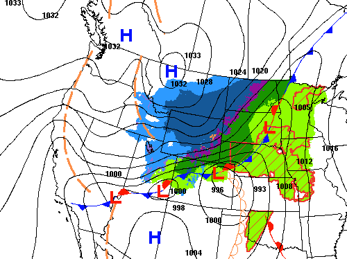
Note: he says it's possible we could see snowfall at a rate of 2" per hour, so despite the ground being warm, it could still accumulate and become very slick. Please allot additional travel time, take it slow, leave extra room between you and the car in front of you, and be safe getting around!
Red Flag Warning Wednesday... Snow Thursday...
Extreme changes to our weather are coming up. If you've lived here a while, you know it's pretty typical. Warm and gusty conditions Wednesday, with low relative humidity, will cause high wildfire danger through Wednesday evening. Then a cold front will cross into the state late Wednesday, rapidly chilling our temperatures, and causing snow showers and snow squalls. Some of these squalls could produce locally heavy snowfall, so please be prepared for winter driving conditions from Wednesday night into early Friday. Accumulating snow is likely, not only in the foothills, but also into the Denver metro area, so plan your travel accordingly. Roads are likely to be slick, snow packed and icy. Wind will also be occasionally gusty causing poor visibility. Check your tires and washer fluid before the snow begins late Wednesday night. **Please note: The expected snow accumulations shown in the forecasts below, account for "snow squalls", which may deliver brief heavy snowfall on a highly unpredictable basis. Total accumulation may be significantly less than what we are predicting, however we want you to be prepared.**
Details for each town on our weather page here: mymountaintown.com/expert-local-weather check back for updates as the storm progresses
Note: he says it's possible we could see snowfall at a rate of 2" per hour, so despite the ground being warm, it could still accumulate and become very slick. Please allot additional travel time, take it slow, leave extra room between you and the car in front of you, and be safe getting around!
Please Log in or Create an account to join the conversation.
- MountainTownAlerts
-
Topic Author
- Mountain Legend
-
Less
More
- Posts: 9766
- Thank you received: 221
09 Oct 2019 08:53 - 09 Oct 2019 08:54 #2
by MountainTownAlerts
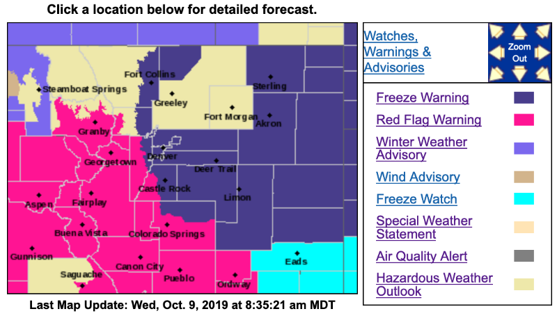
Red Flag Warning
URGENT - FIRE WEATHER MESSAGE
National Weather Service Denver/Boulder CO
357 AM MDT Wed Oct 9 2019
...RED FLAG WARNING FOR THE CENTRAL MOUNTAINS AND HIGH VALLEYS... SOUTHERN FRONT RANGE FOOTHILLS...AND PALMER DIVIDE NOON TO 6 PM WEDNESDAY FOR GUSTY WINDS AND LOW HUMIDITY...FIRE WEATHER ZONES 212...213...214...216...241...AND 247...
.Gusty winds and low relative humidities are expected again this afternoon over the northern Colorado mountains, spreading out onto the plains. The worst conditions will be along and south of Interstate 70.
COZ212>214-216-091800-
/O.CON.KBOU.FW.W.0016.191009T1800Z-191010T0000Z/
South and Southeast Grand/West Central and Southwest Boulder/
Gilpin/Clear Creek/Summit/North and West Park Counties Above 9000 Feet-
Grand and Summit Counties Below 9000 Feet-
Central and Southeast Park County-
Jefferson and West Douglas Counties Above 6000 Feet/Gilpin/Clear Creek/Northeast Park Counties Below 9000 Feet-
357 AM MDT Wed Oct 9 2019
...RED FLAG WARNING IN EFFECT FROM NOON TODAY TO 6 PM MDT THIS EVENING FOR WIND AND LOW RELATIVE HUMIDITY FOR THE CENTRAL MOUNTAINS AND HIGH MOUNTAIN VALLEYS...AND THE SOUTHERN FRONT RANGE FOOTHILLS...FIRE WEATHER ZONES 212...213...214...AND 216.
* Affected Area...Fire Weather Zones 212...213...214 and 216.
* Winds...Southwest 10 to 20 mph with gusts up to 35 mph.
* Timing...Wednesday from Noon through 6pm.
* Relative Humidity...As low as 11 percent.
* Impacts...Conditions will be favorable for the rapid ignition, growth, and spread of fires.
PRECAUTIONARY/PREPAREDNESS ACTIONS...
A Red Flag Warning means that critical fire weather conditions are either occurring now....or will shortly. A combination of strong winds...low relative humidity...and warm temperatures can contribute to extreme fire behavior.
***************************************************
Freeze Warning
URGENT - WEATHER MESSAGE
National Weather Service Denver CO
418 AM MDT Wed Oct 9 2019
COZ038>041-045>047-049-092100-
/O.UPG.KBOU.FZ.A.0003.191010T0200Z-191010T1500Z/
/O.NEW.KBOU.FZ.W.0002.191010T0400Z-191010T1500Z/
Larimer County Below 6000 Feet/Northwest Weld County-
Boulder And Jefferson Counties Below 6000 Feet/West Broomfield County-
North Douglas County Below 6000 Feet/Denver/West Adams and Arapahoe Counties/East Broomfield County-
Elbert/Central and East Douglas Counties Above 6000 Feet-
Central and East Adams and Arapahoe Counties-
North and Northeast Elbert County Below 6000 Feet/North Lincoln County-
Southeast Elbert County Below 6000 Feet/South Lincoln County-
Washington County-
Including the cities of Fort Collins, Hereford, Loveland, Nunn, Arvada, Boulder, Golden, Lakewood, Longmont, Aurora, Brighton, City of Denver, Denver International Airport, Highlands Ranch, Littleton, Parker, Castle Rock, Elbert, Fondis, Kiowa, Larkspur, Bennett, Byers, Deer Trail, Leader, Agate, Hugo, Limon, Matheson, Forder, Karval, Kutch, Punkin Center, Akron, Cope, Last Chance, and Otis
418 AM MDT Wed Oct 9 2019
...FREEZE WARNING IN EFFECT FROM 10 PM THIS EVENING TO 9 AM MDT THURSDAY...
* WHAT...Sub-freezing temperatures as low as 20 expected.
* WHERE...Northeast and East Central Colorado, including the Denver Metro area.
* WHEN...Freezing temperatures as early as 10 PM Wednesday.
* IMPACTS...Frost and freeze conditions will kill crops, other sensitive vegetation and damage unprotected outdoor plumbing.
PRECAUTIONARY/PREPAREDNESS ACTIONS...
Take steps now to protect tender plants from the cold. To prevent freezing and possible bursting of outdoor water pipes they should be wrapped, drained, or allowed to drip slowly. Those that have in-ground sprinkler systems should drain them and cover above-ground pipes to protect them from freezing.
Replied by MountainTownAlerts on topic MMT Weather Forecast Oct 8: Red Flag Warning Wednesday, Snow Thursday
Red Flag Warning
URGENT - FIRE WEATHER MESSAGE
National Weather Service Denver/Boulder CO
357 AM MDT Wed Oct 9 2019
...RED FLAG WARNING FOR THE CENTRAL MOUNTAINS AND HIGH VALLEYS... SOUTHERN FRONT RANGE FOOTHILLS...AND PALMER DIVIDE NOON TO 6 PM WEDNESDAY FOR GUSTY WINDS AND LOW HUMIDITY...FIRE WEATHER ZONES 212...213...214...216...241...AND 247...
.Gusty winds and low relative humidities are expected again this afternoon over the northern Colorado mountains, spreading out onto the plains. The worst conditions will be along and south of Interstate 70.
COZ212>214-216-091800-
/O.CON.KBOU.FW.W.0016.191009T1800Z-191010T0000Z/
South and Southeast Grand/West Central and Southwest Boulder/
Gilpin/Clear Creek/Summit/North and West Park Counties Above 9000 Feet-
Grand and Summit Counties Below 9000 Feet-
Central and Southeast Park County-
Jefferson and West Douglas Counties Above 6000 Feet/Gilpin/Clear Creek/Northeast Park Counties Below 9000 Feet-
357 AM MDT Wed Oct 9 2019
...RED FLAG WARNING IN EFFECT FROM NOON TODAY TO 6 PM MDT THIS EVENING FOR WIND AND LOW RELATIVE HUMIDITY FOR THE CENTRAL MOUNTAINS AND HIGH MOUNTAIN VALLEYS...AND THE SOUTHERN FRONT RANGE FOOTHILLS...FIRE WEATHER ZONES 212...213...214...AND 216.
* Affected Area...Fire Weather Zones 212...213...214 and 216.
* Winds...Southwest 10 to 20 mph with gusts up to 35 mph.
* Timing...Wednesday from Noon through 6pm.
* Relative Humidity...As low as 11 percent.
* Impacts...Conditions will be favorable for the rapid ignition, growth, and spread of fires.
PRECAUTIONARY/PREPAREDNESS ACTIONS...
A Red Flag Warning means that critical fire weather conditions are either occurring now....or will shortly. A combination of strong winds...low relative humidity...and warm temperatures can contribute to extreme fire behavior.
***************************************************
Freeze Warning
URGENT - WEATHER MESSAGE
National Weather Service Denver CO
418 AM MDT Wed Oct 9 2019
COZ038>041-045>047-049-092100-
/O.UPG.KBOU.FZ.A.0003.191010T0200Z-191010T1500Z/
/O.NEW.KBOU.FZ.W.0002.191010T0400Z-191010T1500Z/
Larimer County Below 6000 Feet/Northwest Weld County-
Boulder And Jefferson Counties Below 6000 Feet/West Broomfield County-
North Douglas County Below 6000 Feet/Denver/West Adams and Arapahoe Counties/East Broomfield County-
Elbert/Central and East Douglas Counties Above 6000 Feet-
Central and East Adams and Arapahoe Counties-
North and Northeast Elbert County Below 6000 Feet/North Lincoln County-
Southeast Elbert County Below 6000 Feet/South Lincoln County-
Washington County-
Including the cities of Fort Collins, Hereford, Loveland, Nunn, Arvada, Boulder, Golden, Lakewood, Longmont, Aurora, Brighton, City of Denver, Denver International Airport, Highlands Ranch, Littleton, Parker, Castle Rock, Elbert, Fondis, Kiowa, Larkspur, Bennett, Byers, Deer Trail, Leader, Agate, Hugo, Limon, Matheson, Forder, Karval, Kutch, Punkin Center, Akron, Cope, Last Chance, and Otis
418 AM MDT Wed Oct 9 2019
...FREEZE WARNING IN EFFECT FROM 10 PM THIS EVENING TO 9 AM MDT THURSDAY...
* WHAT...Sub-freezing temperatures as low as 20 expected.
* WHERE...Northeast and East Central Colorado, including the Denver Metro area.
* WHEN...Freezing temperatures as early as 10 PM Wednesday.
* IMPACTS...Frost and freeze conditions will kill crops, other sensitive vegetation and damage unprotected outdoor plumbing.
PRECAUTIONARY/PREPAREDNESS ACTIONS...
Take steps now to protect tender plants from the cold. To prevent freezing and possible bursting of outdoor water pipes they should be wrapped, drained, or allowed to drip slowly. Those that have in-ground sprinkler systems should drain them and cover above-ground pipes to protect them from freezing.
Last edit: 09 Oct 2019 08:54 by MountainTownAlerts.
Please Log in or Create an account to join the conversation.
- Forum
- Life Up the Hill
- Scanner & Emergency Info, Weather Forecasts
- MMT Weather Forecast Oct 8: Red Flag Warning Wednesday, Snow Thursday
Time to create page: 0.167 seconds
sponsors


