- Posts: 9766
- Thank you received: 221
- Forum
- Life Up the Hill
- Scanner & Emergency Info, Weather Forecasts
- Winter Storm Watch issued for October 23-24
Winter Storm Watch issued for October 23-24
- MountainTownAlerts
-
 Topic Author
- Mountain Legend
-

Less
More
22 Oct 2019 17:14 #1
by MountainTownAlerts
Winter Storm Watch issued for October 23-24 was created by MountainTownAlerts
My Mountain Town Weather: URGENT
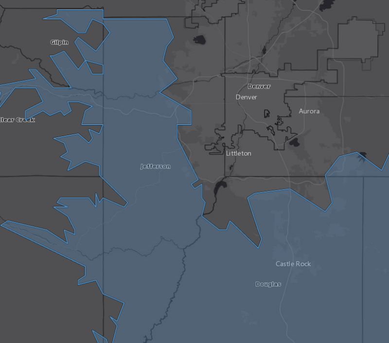
Winter Storm Watch (Blue Area On Map)
A cold front is expected to move through the foothills on Wednesday, bringing cold temperatures and a period of strong upslope flow. There is sufficient moisture in the atmosphere for the potential of heavy snowfall. A Winter Storm Watch is in effect. This may change to a Winter Weather Advisory, or a Winter Storm Warning. (Warnings/Watches are only officially issued by NWS.) We will keep you advised. In the meantime, please prepare for potentially heavy snow and slick road conditions Wednesday into Thursday. mymountaintown.com/expert-local-weather
Winter Storm Watch
URGENT - WINTER WEATHER MESSAGE
National Weather Service Denver CO
351 PM MDT Tue Oct 22 2019
...HEAVY SNOW POSSIBLE WEDNESDAY EVENING...
.Snow will develop over the southern foothills and Palmer Divide late Wednesday afternoon. The snow may be heavy at times Wednesday evening before tapering off overnight. Snowfall of 4 to 8 inches is expected, with up to 12 inches possible in the foothills southwest of Denver. Hazardous road conditions are expected to develop, possibly as early as rush hour, with the worst conditions Wednesday evening. Snow will decrease early Thursday morning, but there may still be some effect on road conditions for the Thursday morning rush hour.
COZ036-041-231100-
/O.EXT.KBOU.WS.A.0012.191024T0000Z-191024T1400Z/
The Southern Front Range Foothills-Castle Rock-
Including the cities of Bailey, Central City, Evergreen, Georgetown, Idaho Springs, Westcreek, Castle Rock, Elbert, Fondis, Kiowa, and Larkspur
351 PM MDT Tue Oct 22 2019
...WINTER STORM WATCH NOW IN EFFECT FROM WEDNESDAY EVENING THROUGH THURSDAY MORNING...
* WHAT...Heavy snow possible. Total snow accumulations of 5 to 8 inches possible, with up to 12 inches in the foothills southwest of Denver.
* WHERE...The Southern Front Range Foothills and Palmer Divide.
* WHEN...From Wednesday evening through Thursday morning.
* IMPACTS...Travel could be very difficult. The hazardous conditions could develop during the Wednesday evening rush hour, and may linger into early Thursday morning.
PRECAUTIONARY/PREPAREDNESS ACTIONS...
Be prepared for winter travel conditions Wednesday evening through early Thursday morning. Monitor later forecasts and consider alternate plans or expect slow travel during the period of heaviest snow.
Please Log in or Create an account to join the conversation.
- MountainTownAlerts
-
Topic Author
- Mountain Legend
-
Less
More
- Posts: 9766
- Thank you received: 221
22 Oct 2019 22:16 #2
by MountainTownAlerts
Replied by MountainTownAlerts on topic Winter Storm Watch issued for October 23-24
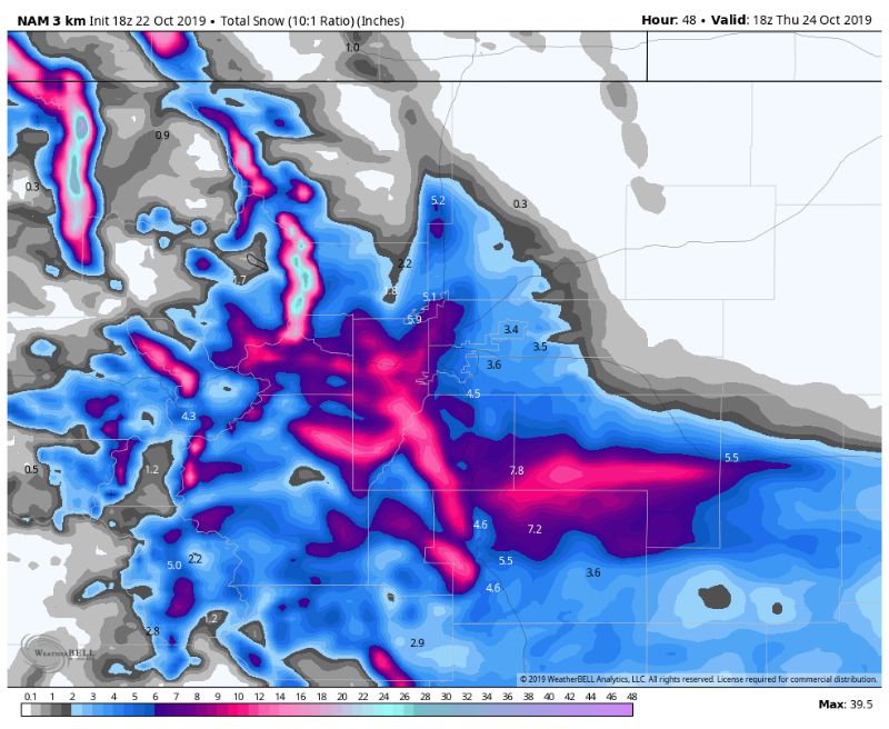
Steve's
updated forecast, with snow totals:
Morrison
My Mountain Town Weather: Winter Storm Watch:
We don't usually post forecast models, however... This is an indication of how much snow we "might" receive across the foothills and Palmer Divide. This is a model, not a forecast. IF conditions come together, (upslope, moisture, temperature drop, cold front timing, etc.), this is one possible outcome. The model shown is the NAM (North American Model). It is but one of several models, and they are not all consistent at this point. In any case, be prepared for snow and slick roads from late WED afternoon until about midday THURS.
Morrison
- Wednesday: Turning cloudy with afternoon rain showers. High: 50. Breezy.
- Wednesday Night: Rain changing to snow my mid evening. 2 to 4 inches possible. Breezy. Low: Lower 20s.
- Thursday: A few morning snow showers. Some clearing in the afternoon. High: Mid 30s.
- Friday: Sunny and warmer. High: Lower 50s.
- Wednesday: Turning cloudy with afternoon snow showers. High: Lower 40s. Gusty wind.
- Wednesday Night: Snow. 5 to 9 inches possible. Periods of heavy snow possible. Gusty wind. Low: 20.
- Thursday: Snow showers in the morning, then some clearing by afternoon. Breezy. High: 30.
- Friday: Sunny and warmer. High: Upper 40s.
- Wednesday: Afternoon rain showers, mixing with snow. Gusty wind. High: Mid 40s.
- Wednesday Night: Snow. 5 to 9 inches possible. Areas of heavy snow possible. Breezy. Low: Upper teens.
- Thursday: A few morning snow showers, then some clearing by afternoon. High: 30.
- Friday: Sunny and warmer. High: Upper 40s.
- Wednesday: Afternoon rain showers, mixing with snow by late afternoon. High: Upper 40s. Breezy.
- Wednesday Night: Snow. 5 to 8 inches possible. Periods of heavy snow possible. Low: 20. Breezy.
- Thursday: Morning snow showers possible, then clearing in the afternoon. High: Low to mid 30s.
- Friday: Sunny and warmer. High: 50.
- Wednesday: Partly cloudy and gusty, with rain or snow showers possible. High: Lower 40s.
- Wednesday Night: Snow. 5 to 10 inches possible. Low: 20. Areas of heavy snow possible. Gusty wind.
- Thursday: Snow showers possible in the morning, then clearing in the afternoon. High: 30.
- Friday: Sunny and warmer. High: Upper 40s.
- Wednesday: Turning cloudy and windy with a few afternoon snow showers. Gusty. High: Upper 30s.
- Wednesday Night: Snow. 2 to 5 inches possible. Breezy. Low: Mid teens. Areas of heavy snow possible.
- Thursday: A few morning snow showers, then some clearing. High: Mid 20s. Breezy.
- Friday: Sunny and warmer. High: Mid 40s.
- Wednesday: Turning cloudy with afternoon snow showers possible. Gusty wind. High: Upper 30s.
- Wednesday Night: Snow. 3 to 7 inches possible. Gusty wind. Low: Mid teens.
- Thursday: Morning snow showers, then clearing in the afternoon. High: Upper 20s. Breezy.
- Friday: Sunny, breezy and warmer. High: Mid 40s.
- Wednesday: Turning cloudy with afternoon snow showers. High: Mid 30s. Wind gusting to 35 mph.
- Wednesday Night: Snow. 3 to 7 inches possible. Gusty wind. Low: Upper teens.
- Thursday: A few early snow showers, then afternoon clearing. Breezy. High: Mid 20s.
- Friday: Sunny, breezy and warmer. High: Lower 40s.
My Mountain Town Weather: Winter Storm Watch:
We don't usually post forecast models, however... This is an indication of how much snow we "might" receive across the foothills and Palmer Divide. This is a model, not a forecast. IF conditions come together, (upslope, moisture, temperature drop, cold front timing, etc.), this is one possible outcome. The model shown is the NAM (North American Model). It is but one of several models, and they are not all consistent at this point. In any case, be prepared for snow and slick roads from late WED afternoon until about midday THURS.
Please Log in or Create an account to join the conversation.
- Forum
- Life Up the Hill
- Scanner & Emergency Info, Weather Forecasts
- Winter Storm Watch issued for October 23-24
Time to create page: 0.178 seconds
sponsors


