The previous Winter Storm Watch has been revised to a Winter Storm Warning and Winter Weather Advisory.
URGENT - WINTER WEATHER MESSAGE
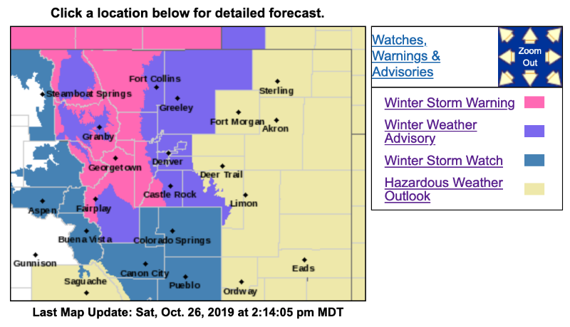
National Weather Service Denver CO
154 PM MDT Sat Oct 26 2019
...WINTER WEATHER FOR NORTHERN COLORADO LATE TONIGHT THROUGH MONDAY...
.A storm system will bring cold and snowy weather to north central and northeast Colorado tonight through Monday. Snow is expected to develop over the northern mountains late tonight and develop south past Interstate 70 into the central mountains Sunday morning. On the plains and in the eastern foothills, freezing drizzle will develop overnight, changing to snow Sunday morning. The combination of a little ice with light snow on top of it may make travel conditions hazardous Sunday morning even with only a small amount of snow. The threat of this is greatest in the foothills north of Interstate 70 and near the Wyoming border early Sunday morning.
The heaviest snow is expected to move into the northern mountains Sunday afternoon and into the central mountains and onto the plains Sunday night and possibly into Monday morning. Lighter snow will continue after that.
Most areas will see hazardous road conditions by Sunday evening and they will continue through at least the Monday morning rush hour.
COZ036-270400-
/O.UPG.KBOU.WS.A.0013.191027T1800Z-191029T0000Z/
/O.NEW.KBOU.WS.W.0015.191027T0900Z-191029T0000Z/
The Southern Front Range Foothills-
Including the cities of Bailey, Central City, Evergreen, Georgetown, Idaho Springs, and Westcreek
154 PM MDT Sat Oct 26 2019
...
WINTER STORM WARNING IN EFFECT FROM 3 AM SUNDAY TO 6 PM MDT MONDAY...
* WHAT...
Freezing drizzle followed by heavy snow. After a light glaze of ice, total snow accumulations will be 8 to 14 inches.
* WHERE...The Southern Front Range Foothills.
* WHEN...Freezing drizzle is expected early Sunday morning, then snow Sunday through Monday. The heaviest snow will be Sunday night.
* IMPACTS...Travel will be very difficult at time, with the worst conditions Sunday night into Monday morning.
PRECAUTIONARY/PREPAREDNESS ACTIONS...
If you must travel, keep an extra flashlight, food, and water in your vehicle in case of an emergency.
The latest road conditions for the state you are calling from can be obtained by calling 5 1 1.
* * * * * * * * * * * * * * * * * * * * * * * * * * * * * * * * * * * * * * * * * * * * *
URGENT - WINTER WEATHER MESSAGE
National Weather Service Denver CO
154 PM MDT Sat Oct 26 2019
...WINTER WEATHER FOR NORTHERN COLORADO LATE TONIGHT THROUGH MONDAY...
COZ034-270400-
/O.UPG.KBOU.WS.A.0013.191027T1200Z-191029T0000Z/
/O.NEW.KBOU.WS.W.0015.191027T1500Z-191029T0000Z/
The Mountains of Summit County, the Mosquito Range, and the Indian Peaks-
Including the cities of Berthoud Pass, Breckenridge, East Slopes Mosquito Range, East Slopes Southern Gore Range, Eisenhower Tunnel, Indian Peaks, Kenosha Mountains, Mount Evans, Williams Fork Mountains, and Winter Park
154 PM MDT Sat Oct 26 2019
...
WINTER STORM WARNING IN EFFECT FROM 9 AM SUNDAY TO 6 PM MDT MONDAY...
* WHAT...Heavy snow expected.
Total snow accumulations of 8 to 14 inches.
* WHERE...The Mountains of Summit County, the Mosquito Range, and the Indian Peaks.
* WHEN...Snow will develop Sunday morning and continue through Monday. The heaviest snow will be Sunday night.
* IMPACTS...
Travel could be very difficult, with the worst conditions from Sunday afternoon through Monday morning. The cold wind chills as low as 20 below zero could cause frostbite on exposed skin in as little as 30 minutes.
PRECAUTIONARY/PREPAREDNESS ACTIONS...
If you must travel, keep an extra flashlight, food, and water in your vehicle in case of an emergency.
The latest road conditions for the state you are calling from can be obtained by calling 5 1 1.
* * * * * * * * * * * * * * * * * * * * * * * * * * * * * * * * * * * * * * * * * * * * *
Winter Weather Advisory
URGENT - WINTER WEATHER MESSAGE
National Weather Service Denver CO
154 PM MDT Sat Oct 26 2019
...WINTER WEATHER FOR NORTHERN COLORADO LATE TONIGHT THROUGH MONDAY...
COZ037-270400-
/O.UPG.KBOU.WS.A.0013.191027T1800Z-191029T0000Z/
/O.NEW.KBOU.WW.Y.0033.191027T1500Z-191029T0000Z/
South Park-
Including the cities of Fairplay, Hartsel, Lake George, and South Park
154 PM MDT Sat Oct 26 2019
...
WINTER WEATHER ADVISORY IN EFFECT FROM 9 AM SUNDAY TO 6 PM MDT MONDAY...
* WHAT...Snow expected.
Total snow accumulations of 5 to 10 inches.
* WHERE...South Park.
* WHEN...Snow will develop by midday Sunday and continue through Monday. The main snow accumulation will be Sunday night.
* IMPACTS...Plan on slippery road conditions. The worst conditions will be Sunday night into Monday morning.
PRECAUTIONARY/PREPAREDNESS ACTIONS...
Slow down and use caution while traveling.
The latest road conditions for the state you are calling from can be obtained by calling 5 1 1.