- Posts: 9766
- Thank you received: 221
- Forum
- Life Up the Hill
- Scanner & Emergency Info, Weather Forecasts
- Winter Storm Warning & Winter Weather Advisory October 29-30
Winter Storm Warning & Winter Weather Advisory October 29-30
- MountainTownAlerts
-
 Topic Author
- Mountain Legend
-

Less
More
28 Oct 2019 16:23 #1
by MountainTownAlerts
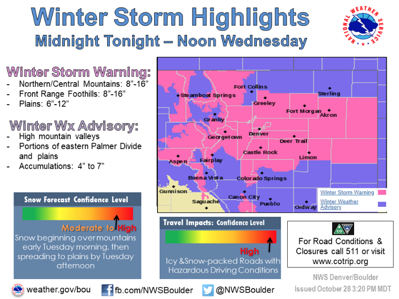
Winter Storm Warning
URGENT - WINTER WEATHER MESSAGE...RESENT
National Weather Service Denver CO
311 PM MDT Mon Oct 28 2019
...SNOW AND COLD FOR TUESDAY THROUGH WEDNESDAY MORNING...
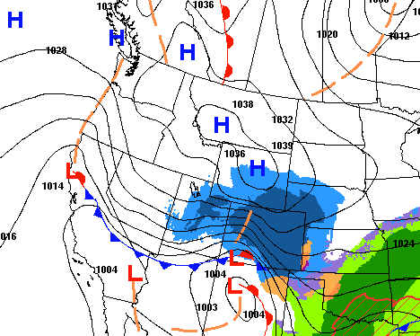
.A storm system will drop south out of the Northern Rockies tonight and Tuesday and will be centered over the Four Corners Tuesday night. The storm system will then track east across Colorado late Tuesday night and Wednesday. Snow will form ahead of the storm system late tonight over north central Colorado. The snow will spread southeast early Tuesday morning with snow expected to begin in Denver Tuesday morning during the morning rush hour.
Snow and cold will push southeast Tuesday and Tuesday night. Roads are expected to be snow covered and slippery for the Tuesday evening and Wednesday morning commute. Because this will be cold system, snow will be able to easily accumulate on roadways. Tuesday morning commute may not be difficult, but the roads will be snow covered for return trip home. If traveling Tuesday or Wednesday morning consider adjusting you travel plans.
COZ035-036-291200-
/O.NEW.KBOU.WS.W.0016.191029T0600Z-191030T1800Z/
The Northern Front Range Foothills-
The Southern Front Range Foothills-
Including the cities of Estes Park, Glendevey, Nederland, Red Feather Lakes, Bailey, Central City, Evergreen, Georgetown, Idaho Springs, and Westcreek
311 PM MDT Mon Oct 28 2019
...WINTER STORM WARNING IN EFFECT FROM MIDNIGHT TONIGHT TO NOON MDT WEDNESDAY...
* WHAT...Heavy snow expected. Total snow accumulations of 8 to 16 inches.
* WHERE...The Northern Front Range Foothills and The Southern Front Range Foothills.
* WHEN...From midnight tonight to noon MDT Wednesday.
* IMPACTS...Travel is expected to be very difficult. The hazardous conditions are expected to impact the Tuesday evening and Wednesday morning commute. The cold wind chills as low as 20 below zero could cause frostbite on exposed skin in as little as 30 minutes.
PRECAUTIONARY/PREPAREDNESS ACTIONS...
If you must travel, keep an extra flashlight, food, and water in your vehicle in case of an emergency.
The latest road conditions for the state you are calling from can be obtained by calling 5 1 1.
* * * * * * * * * * * * * * * * * * * * * * * * * * * * * * * * * * * * * *
URGENT - WINTER WEATHER MESSAGE...RESENT
National Weather Service Denver CO
311 PM MDT Mon Oct 28 2019
COZ031-033-034-291200-
/O.NEW.KBOU.WS.W.0016.191029T0600Z-191030T1800Z/
Rabbit Ears Pass-
Rocky Mountain National Park and the Medicine Bow Range-
The Mountains of Summit County, the Mosquito Range, and the Indian Peaks-
Including the cities of East Slopes Park and Northern Gore Ranges, Gore Pass, Rabbit Ears Pass, Cameron Pass, Laramie and Medicine Bow Mountains, Rabbit Ears Range, Rocky Mountain National Park, Willow Creek Pass, Berthoud Pass, Breckenridge, East Slopes Mosquito Range, East Slopes Southern Gore Range, Eisenhower Tunnel, Indian Peaks, Kenosha Mountains, Mount Evans, Williams Fork Mountains, and Winter Park
311 PM MDT Mon Oct 28 2019
...WINTER STORM WARNING IN EFFECT FROM MIDNIGHT TONIGHT TO NOON MDT WEDNESDAY...
* WHAT...Heavy snow expected. Total snow accumulations of 8 to 16 inches. Winds gusting as high as 35 mph.
* WHERE...Rabbit Ears Pass, Rocky Mountain National Park and the Medicine Bow Range and The Mountains of Summit County, the Mosquito Range, and the Indian Peaks.
* WHEN...From midnight tonight to noon MDT Wednesday.
* IMPACTS...Travel is expected to be very difficult due to snow covered roads. The dangerously cold wind chills as low as 30 below zero could cause frostbite on exposed skin in as little as 10 minutes.
PRECAUTIONARY/PREPAREDNESS ACTIONS...
If you must travel, keep an extra flashlight, food, and water in your vehicle in case of an emergency.
The latest road conditions for the state you are calling from can be obtained by calling 5 1 1.
* * * * * * * * * * * * * * * * * * * * * * * * * * * * * * * * * * * * * *
Winter Weather Advisory
URGENT - WINTER WEATHER MESSAGE...RESENT
National Weather Service Denver CO
311 PM MDT Mon Oct 28 2019
...SNOW AND COLD FOR TUESDAY THROUGH WEDNESDAY MORNING...
COZ037-047-291200-
/O.NEW.KBOU.WW.Y.0034.191029T1500Z-191030T1800Z/
South Park-
Southern Lincoln County-
Including the cities of Fairplay, Hartsel, Lake George, South Park, Forder, Karval, Kutch, and Punkin Center
311 PM MDT Mon Oct 28 2019
...WINTER WEATHER ADVISORY IN EFFECT FROM 9 AM TUESDAY TO NOON MDT WEDNESDAY...
* WHAT...Snow expected. Total snow accumulations of 4 to 7 inches. Winds gusting as high as 35 mph.
* WHERE...South Park and Southern Lincoln County.
* WHEN...From 9 AM Tuesday to noon MDT Wednesday.
* IMPACTS...Plan on slippery road conditions. The cold wind chills as low as 20 below zero could cause frostbite on exposed skin in as little as 30 minutes.
Winter Storm Warning
URGENT - WINTER WEATHER MESSAGE...RESENT
National Weather Service Denver CO
311 PM MDT Mon Oct 28 2019
...SNOW AND COLD FOR TUESDAY THROUGH WEDNESDAY MORNING...
.A storm system will drop south out of the Northern Rockies tonight and Tuesday and will be centered over the Four Corners Tuesday night. The storm system will then track east across Colorado late Tuesday night and Wednesday. Snow will form ahead of the storm system late tonight over north central Colorado. The snow will spread southeast early Tuesday morning with snow expected to begin in Denver Tuesday morning during the morning rush hour.
Snow and cold will push southeast Tuesday and Tuesday night. Roads are expected to be snow covered and slippery for the Tuesday evening and Wednesday morning commute. Because this will be cold system, snow will be able to easily accumulate on roadways. Tuesday morning commute may not be difficult, but the roads will be snow covered for return trip home. If traveling Tuesday or Wednesday morning consider adjusting you travel plans.
COZ035-036-291200-
/O.NEW.KBOU.WS.W.0016.191029T0600Z-191030T1800Z/
The Northern Front Range Foothills-
The Southern Front Range Foothills-
Including the cities of Estes Park, Glendevey, Nederland, Red Feather Lakes, Bailey, Central City, Evergreen, Georgetown, Idaho Springs, and Westcreek
311 PM MDT Mon Oct 28 2019
...WINTER STORM WARNING IN EFFECT FROM MIDNIGHT TONIGHT TO NOON MDT WEDNESDAY...
* WHAT...Heavy snow expected. Total snow accumulations of 8 to 16 inches.
* WHERE...The Northern Front Range Foothills and The Southern Front Range Foothills.
* WHEN...From midnight tonight to noon MDT Wednesday.
* IMPACTS...Travel is expected to be very difficult. The hazardous conditions are expected to impact the Tuesday evening and Wednesday morning commute. The cold wind chills as low as 20 below zero could cause frostbite on exposed skin in as little as 30 minutes.
PRECAUTIONARY/PREPAREDNESS ACTIONS...
If you must travel, keep an extra flashlight, food, and water in your vehicle in case of an emergency.
The latest road conditions for the state you are calling from can be obtained by calling 5 1 1.
* * * * * * * * * * * * * * * * * * * * * * * * * * * * * * * * * * * * * *
URGENT - WINTER WEATHER MESSAGE...RESENT
National Weather Service Denver CO
311 PM MDT Mon Oct 28 2019
COZ031-033-034-291200-
/O.NEW.KBOU.WS.W.0016.191029T0600Z-191030T1800Z/
Rabbit Ears Pass-
Rocky Mountain National Park and the Medicine Bow Range-
The Mountains of Summit County, the Mosquito Range, and the Indian Peaks-
Including the cities of East Slopes Park and Northern Gore Ranges, Gore Pass, Rabbit Ears Pass, Cameron Pass, Laramie and Medicine Bow Mountains, Rabbit Ears Range, Rocky Mountain National Park, Willow Creek Pass, Berthoud Pass, Breckenridge, East Slopes Mosquito Range, East Slopes Southern Gore Range, Eisenhower Tunnel, Indian Peaks, Kenosha Mountains, Mount Evans, Williams Fork Mountains, and Winter Park
311 PM MDT Mon Oct 28 2019
...WINTER STORM WARNING IN EFFECT FROM MIDNIGHT TONIGHT TO NOON MDT WEDNESDAY...
* WHAT...Heavy snow expected. Total snow accumulations of 8 to 16 inches. Winds gusting as high as 35 mph.
* WHERE...Rabbit Ears Pass, Rocky Mountain National Park and the Medicine Bow Range and The Mountains of Summit County, the Mosquito Range, and the Indian Peaks.
* WHEN...From midnight tonight to noon MDT Wednesday.
* IMPACTS...Travel is expected to be very difficult due to snow covered roads. The dangerously cold wind chills as low as 30 below zero could cause frostbite on exposed skin in as little as 10 minutes.
PRECAUTIONARY/PREPAREDNESS ACTIONS...
If you must travel, keep an extra flashlight, food, and water in your vehicle in case of an emergency.
The latest road conditions for the state you are calling from can be obtained by calling 5 1 1.
* * * * * * * * * * * * * * * * * * * * * * * * * * * * * * * * * * * * * *
Winter Weather Advisory
URGENT - WINTER WEATHER MESSAGE...RESENT
National Weather Service Denver CO
311 PM MDT Mon Oct 28 2019
...SNOW AND COLD FOR TUESDAY THROUGH WEDNESDAY MORNING...
COZ037-047-291200-
/O.NEW.KBOU.WW.Y.0034.191029T1500Z-191030T1800Z/
South Park-
Southern Lincoln County-
Including the cities of Fairplay, Hartsel, Lake George, South Park, Forder, Karval, Kutch, and Punkin Center
311 PM MDT Mon Oct 28 2019
...WINTER WEATHER ADVISORY IN EFFECT FROM 9 AM TUESDAY TO NOON MDT WEDNESDAY...
* WHAT...Snow expected. Total snow accumulations of 4 to 7 inches. Winds gusting as high as 35 mph.
* WHERE...South Park and Southern Lincoln County.
* WHEN...From 9 AM Tuesday to noon MDT Wednesday.
* IMPACTS...Plan on slippery road conditions. The cold wind chills as low as 20 below zero could cause frostbite on exposed skin in as little as 30 minutes.
Please Log in or Create an account to join the conversation.
- MountainTownAlerts
-
Topic Author
- Mountain Legend
-
Less
More
- Posts: 9766
- Thank you received: 221
28 Oct 2019 20:04 #2
by MountainTownAlerts
Replied by MountainTownAlerts on topic Winter Storm Warning & Winter Weather Advisory October 29-30
My Mountain Town Weather from Chief Meteorologist Steve Hamilton:
Winter Storm Warning 6AM Tuesday to 12Noon Wednesday...
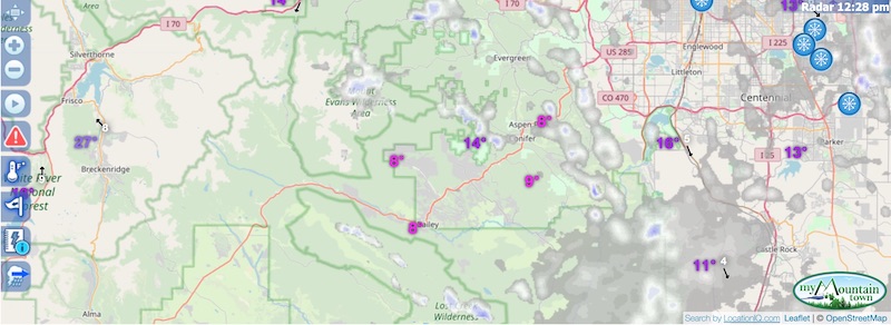
Another round of snow is expected for the foothills, Tuesday afternoon into Wednesday morning. We'll have a period of upslope conditions, and sufficient precipitable moisture, to generate another significant snowfall. Bands of locally-heavy snowfall are possible, especially Tuesday night. Additionally, temperatures will remain very cold until Thursday. Icing and snow pack on the roads will make for hazardous driving conditions for the Tuesday PM and Wednesday AM commutes. And don't forget to use our interactive, high-resolution radar map at the top of our weather page to track the snow coming through your area. mymountaintown.com/expert-local-weather
Morrison
Winter Storm Warning 6AM Tuesday to 12Noon Wednesday...
Another round of snow is expected for the foothills, Tuesday afternoon into Wednesday morning. We'll have a period of upslope conditions, and sufficient precipitable moisture, to generate another significant snowfall. Bands of locally-heavy snowfall are possible, especially Tuesday night. Additionally, temperatures will remain very cold until Thursday. Icing and snow pack on the roads will make for hazardous driving conditions for the Tuesday PM and Wednesday AM commutes. And don't forget to use our interactive, high-resolution radar map at the top of our weather page to track the snow coming through your area. mymountaintown.com/expert-local-weather
Morrison
- Tuesday: Snow showers. 2 to 4" possible. High: 20.
- Tuesday Night: Snow showers, with areas of heavy snow. 3 to 7" possible. Low: 0.
- Wednesday: Snow showers, followed by some afternoon clearing. 1 to 2" possible. High: 20. Wind chill: -10.
- Thursday: Sunny and not as cold. High: 40.
- Tuesday: Snow showers. 2 to 5" possible. High: Mid teens. Wind chill: -10.
- Tuesday Night: Snow showers, with areas of heavy snow. 4 to 9" possible. Low: -5. Wind chill: -20.
- Wednesday: Snow showers, followed by some afternoon clearing. High: Mid teens.
- Thursday: Sunny and not as cold. High: Mid 30s.
- Tuesday: Snow showers. 1 to 3" possible. High: Mid teens.
- Tuesday Night: Snow showers, with areas of heavy snow. 4 to 8" possible. Low: 0. Wind chill: -15.
- Wednesday: Snow showers. High: Mid teens. Some clearing in the afternoon.
- Thursday: Sunny and not as cold. High: Mid 30s.
- Tuesday: Snow showers. 1 to 3" possible. High: 20. Breezy.
- Tuesday Night: Snow showers, with some areas of heavy snow. 4 to 8" possible. Low: 0. Wind chill: -15.
- Wednesday: Snow showers. 1 to 2" possible. Some clearing late. High: 20.
- Thursday: Sunny and not as cold. High: Upper 30s.
- Tuesday: Snow showers. 1 to 4" possible. High: Upper teens.
- Tuesday Night: Snow showers, with areas of heavy snow. 4 to 8" possible. Low: 0. Wind chill: -10.
- Wednesday: Snow showers. 1 to 2" possible. Some clearing in the afternoon. High: Mid to upper teens.
- Thursday: Sunny, with a high near 36.
- Tuesday: Snow showers and windy. 2 to 4" possible. High: Upper teens.
- Tuesday Night: Snow showers. 2 to 4" possible. Low: -5. Wind chill: -15.
- Wednesday: Snow showers possible. Some clearing in the afternoon. High: 10. Wind chill: -20.
- Thursday: Sunny and breezy. High: Upper 20s.
- Tuesday: Snow showers. High: Upper teens. 1 to 3" possible. Gusty wind.
- Tuesday Night: Snow showers. 2 to 4" possible. Low: -5. Wind chill: -15.
- Wednesday: Snow showers. High: 10. Wind chill: -15.
- Thursday: Sunny and breezy. High: Upper 20s.
- Tuesday: Snow showers and windy. 2 to 4" possible. High: Mid to upper teens. Wind gusting to 25 mph.
- Tuesday Night: Snow showers, with some areas of heavy snow. 4 to 8" possible. Low: -5.
- Wednesday: Scattered snow showers. Breezy. High: Upper teens. Wind chill: -20.
- Thursday: Sunny and windy. High: 30.
Please Log in or Create an account to join the conversation.
- MountainTownAlerts
-
Topic Author
- Mountain Legend
-
Less
More
- Posts: 9766
- Thank you received: 221
29 Oct 2019 11:29 #3
by MountainTownAlerts
Replied by MountainTownAlerts on topic Winter Storm Warning & Winter Weather Advisory October 29-30
Updated forecast from Chief Meteorologist Steve Hamilton:
Winter Storm Warning 6AM Tuesday to 12Noon Wednesday...
Another round of snow is expected for the foothills, Tuesday afternoon into Wednesday morning. We'll have a period of upslope conditions, and sufficient precipitable moisture, to generate another significant snowfall. Bands of locally-heavy snowfall are possible, especially Tuesday night. Additionally, temperatures will remain very cold and below-zero wind chills will be a factor. Icing and snow pack on the roads will make for hazardous driving conditions for the Tuesday PM and Wednesday AM commutes. Check your location below for specific snowfall total prediction, which will include through Wednesday morning. And don't forget to use our interactive, high-resolution radar map at the top of this page to track the snow coming through your area.
Morrison
- Tuesday: Snow showers. Up to 7" possible. High: 20.
- Tuesday Night: Snow showers, with areas of heavy snow. Up to 5" additional possible. Low: 0.
- Wednesday: Snow showers, followed by some afternoon clearing. 1 to 2" possible. High: 20. Wind chill: -10.
- Thursday: Sunny and not as cold. High: 40.
- Tuesday: Snow showers. Up to 7" possible. High: Mid teens. Wind chill: -10.
- Tuesday Night: Snow showers, with areas of heavy snow. Up to 5" additional possible. Low: -5. Wind chill: -20.
- Wednesday: Snow showers, followed by some afternoon clearing. High: Mid teens.
- Thursday: Sunny and not as cold. High: Mid 30s.
- Tuesday: Snow showers. Up to 5" possible. High: Mid teens.
- Tuesday Night: Snow showers, with areas of heavy snow. Up to 5" additional possible. Low: 0. Wind chill: -15.
- Wednesday: Snow showers. High: Mid teens. Some clearing in the afternoon.
- Thursday: Sunny and not as cold. High: Mid 30s.
- Tuesday: Snow showers. Up to 4" possible. High: 20. Breezy.
- Tuesday Night: Snow showers, with some areas of heavy snow. Up to 5" additional possible. Low: 0. Wind chill: -15.
- Wednesday: Snow showers. Minor accumulation possible. Some clearing late. High: 20.
- Thursday: Sunny and not as cold. High: Upper 30s.
- Tuesday: Snow showers. Up to 5" possible. High: Upper teens.
- Tuesday Night: Snow showers, with areas of heavy snow. Up to 4" additional possible. Low: 0. Wind chill: -10.
- Wednesday: Snow showers. Minor accumulation possible. Some clearing in the afternoon. High: Mid to upper teens.
- Thursday: Sunny, with a high near 36.
- Tuesday: Snow showers and windy. 2 to 4" possible. High: Upper teens.
- Tuesday Night: Snow showers. 2 to 4" possible. Low: -5. Wind chill: -15.
- Wednesday: Snow showers possible. Some clearing in the afternoon. High: 10. Wind chill: -20.
- Thursday: Sunny and breezy. High: Upper 20s.
- Tuesday: Snow showers. High: Upper teens. Up to 5" possible. Gusty wind.
- Tuesday Night: Snow showers. 2 to 4" possible. Low: -5. Wind chill: -15.
- Wednesday: Snow showers. High: 10. Wind chill: -15.
- Thursday: Sunny and breezy. High: Upper 20s.
- Tuesday: Snow showers and windy. 2 to 4" possible. High: Mid to upper teens. Wind gusting to 25 mph.
- Tuesday Night: Snow showers, with some areas of heavy snow. Up to 4" additional possible. Low: -5.
- Wednesday: Scattered snow showers. Breezy. High: Upper teens. Wind chill: -20.
- Thursday: Sunny and windy. High: 30.
Please Log in or Create an account to join the conversation.
- Forum
- Life Up the Hill
- Scanner & Emergency Info, Weather Forecasts
- Winter Storm Warning & Winter Weather Advisory October 29-30
Time to create page: 0.193 seconds
sponsors


