My Mountain Town Weather:
Chilly Today... Temperatures Warm Up Quickly Tomorrow...
Colder air will slide down the Front Range Foothills today, with a round of snow showers lasting through the morning. Some minor accumulation will be possible, but roads could be slick before noon. By afternoon, clouds should begin to clear out, but temperatures will stay chilly through the day. A strong high pressure area will move in on Tuesday, setting up a warmer down-slope flow, so our temperatures will bounce back quickly with sunny skies. The fair weather pattern continues through Wednesday.
mymountaintown.com/expert-local-weather
Weather Alert: A Slippery Monday Morning Commute Expected...
The National Weather Service has posted a Winter Weather Advisory for part of the foothills, from Midnight tonight, until 9 a.m. Monday morning.
A cold front will arrive over eastern Colorado this evening, causing light freezing drizzle and some accumulating snow. Some areas could receive up to 3", with a layer of light ice underneath. This will obviously create difficult travel conditions for the Monday morning commute.
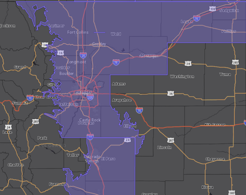
Winter Weather Advisory
URGENT - WINTER WEATHER MESSAGE
National Weather Service Denver CO
255 PM MST Sun Nov 10 2019
...COLD BLAST ON THE WAY ALONG WITH WINTRY PRECIPITATION AND TRAVEL IMPACTS...
.A strong cold front will move across the area early this evening, ushering in much colder air and wintry precipitation. The combination of much colder temperatures, light freezing drizzle, and snow will likely allow roads to become icy and snow covered late tonight. The hazardous winter travel conditions will likely persist through much of the Monday morning commute.
COZ035-036-038>044-048-050-051-110600-
/O.NEW.KBOU.WW.Y.0036.191111T0700Z-191111T1600Z/
The Northern Front Range Foothills-
The Southern Front Range Foothills-
Fort Collins-Boulder and the western suburbs of Denver-Denver-Castle Rock-
Briggsdale-Greeley-Fort Morgan-Sterling-Julesburg-Holyoke-
Including the cities of Estes Park, Glendevey, Nederland, Red Feather Lakes,
Bailey, Central City, Evergreen, Georgetown, Idaho Springs, Westcreek, Fort Collins, Hereford, Loveland, Nunn,
Arvada, Boulder, Golden, Lakewood, Longmont, Aurora, Brighton,
City of Denver, Denver International Airport, Highlands Ranch, Littleton, Parker, Castle Rock, Elbert, Fondis, Kiowa, Larkspur, Briggsdale, Grover, Pawnee Buttes, Raymer, Stoneham, Eaton, Fort Lupton, Greeley, Roggen, Brush, Fort Morgan, Goodrich, Wiggins, Crook, Merino, Sterling, Peetz, Julesburg, Ovid, Sedgwick, Amherst, Haxtun, and Holyoke
255 PM MST Sun Nov 10 2019
...
WINTER WEATHER ADVISORY IN EFFECT FROM MIDNIGHT TONIGHT TO 9 AM MST MONDAY...
* WHAT...
Mixed precipitation of light freezing drizzle and snow expected. Total snow accumulations of 1 to 3 inches and ice accumulations of a light glaze. Winds gusting as high as 35 mph.
* WHERE...Most of north central and northeast Colorado. This includes the Front Range Foothills, I-25 Urban Corridor, and eastern plains along and north of the I-76 Corridor.
* WHEN...From midnight tonight to 9 AM MST Monday.
* IMPACTS...Plan on slippery road conditions. The hazardous conditions will likely impact the Monday morning commute.
PRECAUTIONARY/PREPAREDNESS ACTIONS...
Slow down and use caution while traveling. Allow plenty of extra time for the Monday morning commute.
The latest road conditions for the state you are calling from can be obtained by calling 5 1 1.