From Chief Meterologist Steve Hamilton: A Double-Dose Of Snow...
Two areas of low pressure will move through the Rockies over the next couple of days, bringing us a couple of snow chances. The first will occur on Wednesday. Precipitation may start as rain for some areas, but changing to snow as colder air filters into the area with high pressure moving in from the north. A second system will roll through on Thursday, with a better chance of accumulating snow across all the foothills. Snow amounts will probably not be very heavy, but will likely be enough to cause travel hazards, especially Thursday into early Friday. We might also get a few snow squalls, which could cause slightly higher local accumulations. The system should clear out by Friday afternoon.
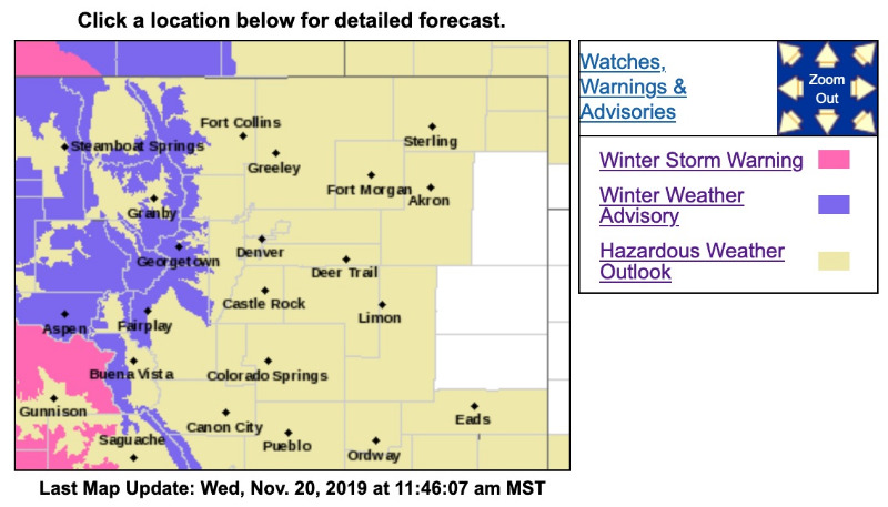
Detailed forecasts and our live radar here:
mymountaintown.com/expert-local-weather
Winter Weather Advisory
URGENT - WINTER WEATHER MESSAGE
National Weather Service Denver CO
423 AM MST Wed Nov 20 2019
...SNOW COMING TO THE MOUNTAINS TODAY AND TONIGHT...
.An upper level storm system moving over Desert Southwest this morning will bring increasing moisture levels to the Colorado mountains by this afternoon which will produce snow through this afternoon and evening. Snow is expected to begin falling over the central and northern mountains by late morning with accumulation rates increasing through the afternoon and early evening hours. Roads may become icy and snow-packed during the afternoon and evening as the storm moves over the state. Snowfall rates are expected to decrease after midnight.
COZ031-033-034-201930-
/O.NEW.KBOU.WW.Y.0037.191120T1200Z-191121T0700Z/
Rabbit Ears Pass-
Rocky Mountain National Park and the Medicine Bow Range-
The Mountains of Summit County, the Mosquito Range, and the Indian Peaks-
Including the cities of East Slopes Park and Northern Gore Ranges, Gore Pass, Rabbit Ears Pass, Cameron Pass, Laramie and Medicine Bow Mountains, Rabbit Ears Range, Rocky Mountain National Park, Willow Creek Pass,
Berthoud Pass, Breckenridge, East Slopes Mosquito Range, East Slopes Southern Gore Range, Eisenhower Tunnel, Indian Peaks, Kenosha Mountains, Mount Evans, Williams Fork Mountains, and Winter Park
423 AM MST Wed Nov 20 2019
...
WINTER WEATHER ADVISORY IN EFFECT UNTIL MIDNIGHT MST TONIGHT...
* WHAT...
Snow expected. Total snow accumulations of 3 to 8 inches.
* WHERE...Rabbit Ears Pass, Rocky Mountain National Park and the Medicine Bow Range and The Mountains of Summit County, the Mosquito Range, and the Indian Peaks.
* WHEN...Snow beginning to fall by late this morning and continuing until midnight MST tonight.
The heaviest snowfall rates will be from about 2 PM through 10 PM.
* IMPACTS...Plan on slippery road conditions. The hazardous conditions could impact the afternoon and evening commute.
PRECAUTIONARY/PREPAREDNESS ACTIONS...
Be prepared for the winter driving conditions that will develop. Slow down and use caution while traveling.
The latest road conditions for the state you are calling from can be obtained by calling 5 1 1.