- Posts: 9766
- Thank you received: 221
- Forum
- Life Up the Hill
- Scanner & Emergency Info, Weather Forecasts
- Winter Storm Warning in effect November 25-26, 2019
Winter Storm Warning in effect November 25-26, 2019
- MountainTownAlerts
-
 Topic Author
- Mountain Legend
-

Less
More
24 Nov 2019 13:22 - 24 Nov 2019 14:32 #1
by MountainTownAlerts
Edit to update 2:30pm: this has just been upgraded to a Winter Storm Warning. The Winter Storm Watch is no longer in effect. See details in 2nd post below.
My Mountain Town Weather from Chief Meteorologist Steve Hamilton: URGENT
Winter Storm Watch - Monday Night Through Tuesday Morning...
A strong winter storm is expected to develop Monday over the Colorado mountains, then move eastward onto the plains, delivering significant accumulating snow to the Front Range Foothills, as well as the northeast plains and the Denver Metro area. Gusty wind is also possible.
Be prepared for deteriorating road conditions by late Monday evening, and icy/snow-packed roads Tuesday morning.
Snowfall accumulations are expected to be 3 to 8 inches for most of the Foothills, with lesser amounts around Fairplay, Alma and Como.
More details shortly... but, get ready. mymountaintown.com/expert-local-weather
Winter Storm Watch
URGENT - WINTER WEATHER MESSAGE
National Weather Service Denver CO
438 AM MST Sun Nov 24 2019
...HEAVY SNOW LIKELY MONDAY NIGHT INTO TUESDAY...
.A winter storm will strengthen as it moves over the mountains and across northeastern Colorado and neighboring states Monday night into Tuesday. A large area of heavy snow is likely from the northern Colorado and southern Wyoming mountains eastward into western Nebraska and northwest Kansas. The heaviest snow will begin in the mountains and late Monday afternoon and spread southeast to the Denver area during the evening, and across the rest of northeast Colorado by about midnight. The snow will end from west to east during the day Tuesday.
This storm will likely cause significant travel difficulties due to the amount of snowfall. A widespread area with a foot of snow from about Interstate 70 northward is possible. Conditions will deteriorate Monday evening and will be worst on Tuesday morning. While blizzard conditions are not expected, north winds at 15 to 30 mph will produce some blowing and drifting snow on the plains during the day Tuesday, which may hamper plowing of roads. Conditions will improve Tuesday afternoon as the snow moves eastward and winds decrease.
People planning travel in northeastern Colorado Monday night or Tuesday should monitor future forecasts and begin to consider alternatives. There is some uncertainty about this storm`s impact on the Denver area as it may be on the edge of this storm. There is a chance that travel could become impossible in the Denver area Tuesday morning, so residents should be prepared for that possibility. Closed or impassible roads due to very heavy snow are more likely in the cities north of Denver and on the plains along and north of Interstate 76.
COZ031-033>036-242345-
/O.NEW.KBOU.WS.A.0014.191126T0100Z-191126T1900Z/
Rabbit Ears Pass-
Rocky Mountain National Park and the Medicine Bow Range-
The Mountains of Summit County, the Mosquito Range, and the Indian Peaks-
The Northern Front Range Foothills-
The Southern Front Range Foothills-
Including the cities of East Slopes Park and Northern Gore Ranges, Gore Pass, Rabbit Ears Pass, Cameron Pass, Laramie and Medicine Bow Mountains, Rabbit Ears Range, Rocky Mountain National Park, Willow Creek Pass, Berthoud Pass, Breckenridge, East Slopes Mosquito Range, East Slopes Southern Gore Range, Eisenhower Tunnel, Indian Peaks, Kenosha Mountains, Mount Evans, Williams Fork Mountains, Winter Park, Estes Park, Glendevey, Nederland, Red Feather Lakes, Bailey, Central City, Evergreen, Georgetown, Idaho Springs, and Westcreek
438 AM MST Sun Nov 24 2019
...WINTER STORM WATCH IN EFFECT FROM MONDAY EVENING THROUGH TUESDAY MORNING...
* WHAT...Heavy snow possible. Total snow accumulations of 8 to 14 inches possible.
* WHERE...The higher mountains of northern Colorado and the Front Range foothills.
* WHEN...Snow will spread from the northern mountains early Monday evening to the Interstate 70 corridor and the foothills southwest of Denver by late evening. The heaviest snow will be Monday night in the northern mountains, and Tuesday morning in areas west and southwest of Denver. The snow will decrease from north to south during the day Tuesday.
* IMPACTS...Travel could be very difficult to impossible, especially Tuesday morning.
PRECAUTIONARY/PREPAREDNESS ACTIONS...
Monitor the latest forecasts for updates on this situation. Consider possible alternatives to travel, especially in the foothills Tuesday morning.
Last edit: 24 Nov 2019 14:32 by MountainTownAlerts. Reason: change in status
Please Log in or Create an account to join the conversation.
- MountainTownAlerts
-
Topic Author
- Mountain Legend
-
Less
More
- Posts: 9766
- Thank you received: 221
24 Nov 2019 14:43 #2
by MountainTownAlerts
Replied by MountainTownAlerts on topic Winter Storm Warning in effect November 25-26, 2019
The Winter Storm Watch is no longer in effect; it has been upgraded to a Winter Storm Warning.
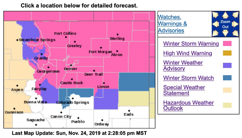
Winter Storm Warning
URGENT - WINTER WEATHER MESSAGE
National Weather Service Denver CO
140 PM MST Sun Nov 24 2019
...HEAVY SNOW LIKELY MONDAY NIGHT INTO TUESDAY...
.A winter storm will strengthen as it moves over the mountains and across northeastern Colorado and neighboring states Monday night into Tuesday. A large area of heavy snow is likely from the northern Colorado and southern Wyoming mountains eastward into western Nebraska and northwest Kansas. The heaviest snow will begin in the mountains Monday afternoon and spread southeast to the Denver-Fort Collins area during the evening, and across the rest of northeast Colorado by about midnight. The snow will end from west to east during the day Tuesday. The heaviest snow is likely to occur late Monday into the early morning hours Tuesday.
This storm will likely cause significant travel difficulties due to the amount of snowfall. A widespread area with a foot of snow from about Interstate 70 northward is possible. Conditions will deteriorate Monday evening and will be worse on Tuesday morning just after the heaviest snowfall occurs. While blizzard conditions are not expected, north winds at 15 to 30 mph will produce some blowing and drifting snow on the plains during the day Tuesday, which may hamper plowing of roads. Conditions will improve Tuesday afternoon as the snow moves eastward and winds decrease.
People planning travel in northeastern Colorado Monday night or Tuesday should monitor future forecasts and begin to consider alternatives. There is a chance that travel could become nearly impossible across the I-25 urban corridor and across much of the northeast plains including the I-76 corridor by Tuesday morning, so residents should be prepared for that possibility. Closed or impassible roads due to heavy snow are possible in the warned area.
COZ033>036-038-250445-
/O.UPG.KBOU.WS.A.0014.191126T0100Z-191126T1900Z/
/O.NEW.KBOU.WS.W.0017.191126T0300Z-191127T0000Z/
Rocky Mountain National Park and the Medicine Bow Range-
The Mountains of Summit County, the Mosquito Range, and the Indian Peaks-
The Northern Front Range Foothills-
The Southern Front Range Foothills-
Fort Collins-
Including the cities of Cameron Pass, Laramie and Medicine Bow Mountains, Rabbit Ears Range, Rocky Mountain National Park, Willow Creek Pass, Berthoud Pass, Breckenridge, East Slopes Mosquito Range, East Slopes Southern Gore Range, Eisenhower Tunnel, Indian Peaks, Kenosha Mountains, Mount Evans, Williams Fork Mountains, Winter Park, Estes Park, Glendevey, Nederland, Red Feather Lakes, Bailey, Central City, Evergreen, Georgetown, Idaho Springs, Westcreek, Fort Collins, Hereford, Loveland, and Nunn
140 PM MST Sun Nov 24 2019
...WINTER STORM WARNING IN EFFECT FROM 8 PM MONDAY TO 5 PM MST TUESDAY...
* WHAT...Heavy snow expected. Total snow accumulations of 8 to 14 inches with the highest amounts under the heaviest bands of snow.
* WHERE...Rocky Mountain National Park and the Medicine Bow Range, The Mountains of Summit County, the Mosquito Range, and the Indian Peaks, The Northern Front Range Foothills, The Southern Front Range Foothills and Fort Collins.
* WHEN...From 8 PM Monday to 5 PM MST Tuesday.
* IMPACTS...Travel could be very difficult to nearly impossible across the northern I-25 corridor and from Greeley to Fort Collins and Loveland. The hazardous conditions could impact the Monday evening commute and will impact the Tuesday morning commute.
PRECAUTIONARY/PREPAREDNESS ACTIONS...
If you must travel, keep an extra flashlight, food, and water in your vehicle in case of an emergency.
The latest road conditions for the state you are calling from can be obtained by calling 5 1 1.
- - - - - - - - - - - - - - - - - - - - - - - - - - - - - - - - - - -
URGENT - WINTER WEATHER MESSAGE
National Weather Service Denver CO
140 PM MST Sun Nov 24 2019
...HEAVY SNOW LIKELY MONDAY NIGHT INTO TUESDAY...
COZ039>046-048>051-250445-
/O.UPG.KBOU.WS.A.0014.191126T0400Z-191126T2200Z/
/O.NEW.KBOU.WS.W.0017.191126T0300Z-191127T0000Z/
Boulder and the western suburbs of Denver-Denver-Castle Rock-Briggsdale-Greeley-Fort Morgan-Byers-Limon-Sterling-Akron-Julesburg-Holyoke-
Including the cities of Arvada, Boulder, Golden, Lakewood, Longmont, Aurora, Brighton, City of Denver, Denver International Airport, Highlands Ranch, Littleton, Parker, Castle Rock, Elbert, Fondis, Kiowa, Larkspur, Briggsdale, Grover, Pawnee Buttes, Raymer, Stoneham, Eaton, Fort Lupton, Greeley, Roggen, Brush, Fort Morgan, Goodrich, Wiggins, Bennett, Byers, Deer Trail, Leader, Agate, Hugo, Limon, Matheson, Crook, Merino, Sterling, Peetz, Akron, Cope, Last Chance, Otis, Julesburg, Ovid, Sedgwick, Amherst, Haxtun, and Holyoke
140 PM MST Sun Nov 24 2019
...WINTER STORM WARNING IN EFFECT FROM 8 PM MONDAY TO 5 PM MST TUESDAY...
* WHAT...Heavy snow expected. Total snow accumulations of 6 to 12 inches with higher amounts possible under the heaviest snow bands. Winds gusting as high as 35 mph.
* WHERE...Portions of east central and northeast Colorado.
* WHEN...From 8 PM Monday to 5 PM MST Tuesday.
* IMPACTS...Travel could be very difficult to nearly impossible across the area, especially by Tuesday morning. The hazardous conditions will impact the Tuesday morning commute.
PRECAUTIONARY/PREPAREDNESS ACTIONS...
If you must travel, keep an extra flashlight, food, and water in your vehicle in case of an emergency.
The latest road conditions for the state you are calling from can be obtained by calling 5 1 1.
- - - - - - - - - - - - - - - - - - - - - - - - - - - - - - - - - - -
Winter Weather Advisory
URGENT - WINTER WEATHER MESSAGE
National Weather Service Denver CO
140 PM MST Sun Nov 24 2019
...HEAVY SNOW LIKELY MONDAY NIGHT INTO TUESDAY...
COZ030-032-037-250445-
/O.NEW.KBOU.WW.Y.0039.191126T0000Z-191126T1800Z/
North Park-Grand and Summit Counties Below 9000 Feet-South Park-
Including the cities of Gould, North Park, Rand, Spicer, Walden, Dillon, Fraser, Granby, Grand Lake, Hot Sulphur Springs, Kremmling, Fairplay, Hartsel, Lake George, and South Park
140 PM MST Sun Nov 24 2019
...WINTER WEATHER ADVISORY IN EFFECT FROM 5 PM MONDAY TO 11 AM MST TUESDAY...
* WHAT...Snow expected. Total snow accumulations of 4 to 6 inches.
* WHERE...North Park, Grand and Summit Counties Below 9000 Feet and South Park.
* WHEN...From 5 PM Monday to 11 AM MST Tuesday.
* IMPACTS...Plan on slippery road conditions.
PRECAUTIONARY/PREPAREDNESS ACTIONS...
Slow down and use caution while traveling.
The latest road conditions for the state you are calling from can be obtained by calling 5 1 1.
Please Log in or Create an account to join the conversation.
- MountainTownAlerts
-
Topic Author
- Mountain Legend
-
Less
More
- Posts: 9766
- Thank you received: 221
24 Nov 2019 23:08 #3
by MountainTownAlerts
Replied by MountainTownAlerts on topic Winter Storm Warning in effect November 25-26, 2019
From the National Weather Service:
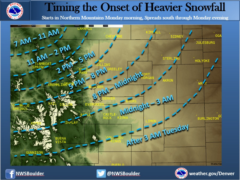
When will the heavier snow begin? Here's a graphic showing just that. Light snow starts early Monday AM in the far northern mountains, but then becomes heavy & spreads southeast late Monday & Monday night. Snowfall rates up to 2 inches per hour as this storm winds up!
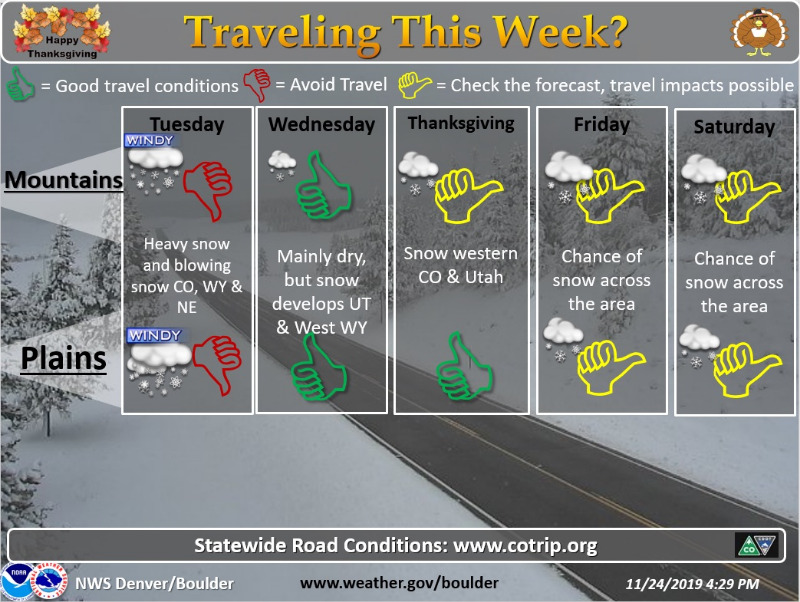
Unfortunately, weather will impact the Thanksgiving holiday travel period. A significant storm will move across Colorado and adjacent states late Monday through Tuesday, so avoid travel if at all possible during this time frame. Better travel conditions can be expected Wednesday, but another storm moves into the area from the west by Thanksgiving and Friday. Make sure you stay updated with the latest forecasts as your travel time nears. Be prepared with a winter preparedness travel kit, and stay safe this holiday travel season.
When will the heavier snow begin? Here's a graphic showing just that. Light snow starts early Monday AM in the far northern mountains, but then becomes heavy & spreads southeast late Monday & Monday night. Snowfall rates up to 2 inches per hour as this storm winds up!
Unfortunately, weather will impact the Thanksgiving holiday travel period. A significant storm will move across Colorado and adjacent states late Monday through Tuesday, so avoid travel if at all possible during this time frame. Better travel conditions can be expected Wednesday, but another storm moves into the area from the west by Thanksgiving and Friday. Make sure you stay updated with the latest forecasts as your travel time nears. Be prepared with a winter preparedness travel kit, and stay safe this holiday travel season.
Please Log in or Create an account to join the conversation.
- MountainTownAlerts
-
Topic Author
- Mountain Legend
-
Less
More
- Posts: 9766
- Thank you received: 221
25 Nov 2019 08:18 #4
by MountainTownAlerts
Replied by MountainTownAlerts on topic Winter Storm Warning in effect November 25-26, 2019
From Chief Meteorologist Steve Hamilton:
Accumulation totals have been adjusted, slightly upward based on latest weather model data. Check your area here: mymountaintown.com/expert-local-weather Needless to say, travel will be difficult and hazardous tonight and most of Tuesday.
Winter Storm Warning 5PM Monday Until 5PM Tuesday...
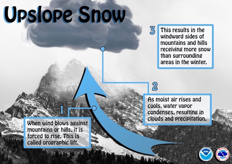
A classic upslope winter storm is heading our way. A strong low pressure system will develop over Colorado by Monday afternoon, strengthening over Southeast Colorado by Monday evening. Cold air will also move into the area with high pressure approaching from the north.
A period of upslope conditions is expected from Monday evening through Tuesday afternoon. There is sufficient moisture with this storm to bring periods of heavy snow across the foothills, the adjacent Denver Metro area, and into Northeast Colorado. Snowfall will begin to taper off Tuesday afternoon.
Travel is likely to be difficult across all of Northeast Colorado through Tuesday evening due to periods of heavy snowfall and gusty wind. Be prepared for icy and snow-packed roads, and blowing snow. If you do not need to travel, it's probably a good idea to stay off the roads because plows may have a hard time keeping up with the snowfall.
Accumulation totals have been adjusted, slightly upward based on latest weather model data. Check your area here: mymountaintown.com/expert-local-weather Needless to say, travel will be difficult and hazardous tonight and most of Tuesday.
Winter Storm Warning 5PM Monday Until 5PM Tuesday...
A classic upslope winter storm is heading our way. A strong low pressure system will develop over Colorado by Monday afternoon, strengthening over Southeast Colorado by Monday evening. Cold air will also move into the area with high pressure approaching from the north.
A period of upslope conditions is expected from Monday evening through Tuesday afternoon. There is sufficient moisture with this storm to bring periods of heavy snow across the foothills, the adjacent Denver Metro area, and into Northeast Colorado. Snowfall will begin to taper off Tuesday afternoon.
Travel is likely to be difficult across all of Northeast Colorado through Tuesday evening due to periods of heavy snowfall and gusty wind. Be prepared for icy and snow-packed roads, and blowing snow. If you do not need to travel, it's probably a good idea to stay off the roads because plows may have a hard time keeping up with the snowfall.
Please Log in or Create an account to join the conversation.
- MountainTownAlerts
-
Topic Author
- Mountain Legend
-
Less
More
- Posts: 9766
- Thank you received: 221
25 Nov 2019 11:01 #5
by MountainTownAlerts
Replied by MountainTownAlerts on topic Winter Storm Warning in effect November 25-26, 2019
CSP Golden @CSP_Golden 45m
We are anticipating Safety Closures along the I-70 corridor tonight and tomorrow. CMV Chain Laws and Passenger Vehicle Traction Laws will be in effect on I-70, US 285, US 6 and US 40.
Current restrictions will be posted at COTRIP.org
We are anticipating Safety Closures along the I-70 corridor tonight and tomorrow. CMV Chain Laws and Passenger Vehicle Traction Laws will be in effect on I-70, US 285, US 6 and US 40.
Current restrictions will be posted at COTRIP.org
Please Log in or Create an account to join the conversation.
- Forum
- Life Up the Hill
- Scanner & Emergency Info, Weather Forecasts
- Winter Storm Warning in effect November 25-26, 2019
Time to create page: 0.219 seconds
sponsors


