- Posts: 9708
- Thank you received: 220
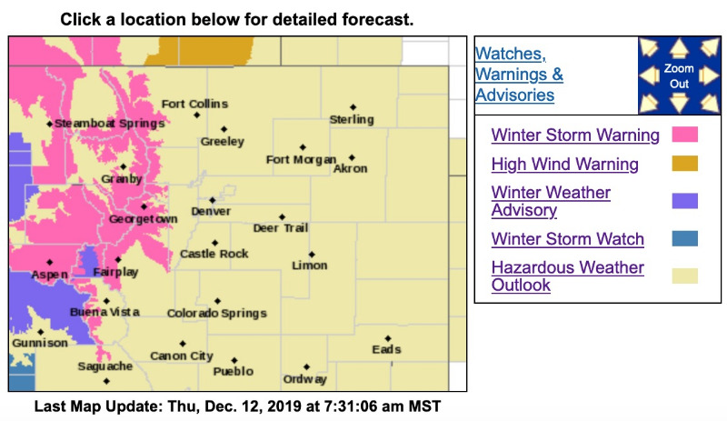
Winter Storm Warning December 12
- MountainTownAlerts
-
 Topic Author
- Mountain Legend
-

Less
More
12 Dec 2019 07:40 #1
by MountainTownAlerts
Winter Storm Warning
URGENT - WINTER WEATHER MESSAGE
National Weather Service Denver CO
410 AM MST Thu Dec 12 2019
...Light to Moderate Snow and Occasional Strong Winds Moving Into the Mountains Tonight and Continuing Through the Weekend...
.A prolonged flow of Pacific moisture is forecast to move into the Rocky Mountains of Colorado from later tonight through the weekend. The moist airmass is being driven by strong westerly winds aloft which will create an efficient snowfall producing storm system. Once snow begins falling in the northern and central Colorado mountains this afternoon or tonight, it is expected to continue falling through Sunday afternoon. Snowfall rates will vary from less than inch an hour up to one or two inches per hour at times. Along with the snowfall, periods of gusty winds may also develop which will create blowing and drifting snow with poor visibilities. The initial period of moderate snowfall is expected tonight and Friday morning with a possible decrease Friday afternoon and evening. A second wave of moisture is then expected to arrive by Saturday which will keep the snow machine running into Sunday. Snowfall accumulations by Friday afternoon could be 12 to 18 inches. Additional accumulations over the weekend could amount to another foot, or more.
Travel through the mountains will be difficult from Friday through Sunday, especially during periods of moderate to heavy snow and strong winds. If you are planning to travel through the mountains Friday through Sunday, check cotrip.org often for the latest road conditions and be prepared for extremely difficult travel conditions.
COZ031-033-034-121915-
/O.NEW.KBOU.WS.W.0018.191213T0000Z-191214T0000Z/
/O.EXT.KBOU.WS.A.0016.191214T0000Z-191215T1200Z/
Rabbit Ears Pass-
Rocky Mountain National Park and the Medicine Bow Range-
The Mountains of Summit County, the Mosquito Range, and the Indian Peaks-
Including the cities of East Slopes Park and Northern Gore Ranges, Gore Pass, Rabbit Ears Pass, Cameron Pass, Laramie and Medicine Bow Mountains, Rabbit Ears Range, Rocky Mountain National Park, Willow Creek Pass, Berthoud Pass, Breckenridge, East Slopes Mosquito Range, East Slopes Southern Gore Range, Eisenhower Tunnel, Indian Peaks, Kenosha Mountains, Mount Evans, Williams Fork Mountains, and Winter Park
410 AM MST Thu Dec 12 2019
...WINTER STORM WARNING IN EFFECT FROM 5 PM THIS AFTERNOON TO 5 PM MST FRIDAY...
...WINTER STORM WATCH NOW IN EFFECT FROM FRIDAY AFTERNOON THROUGH LATE SATURDAY NIGHT...
* WHAT...For the Winter Storm Warning, heavy snow expected. Total snow accumulations of 12 to 18 inches. Winds gusting as high as 60 mph at times. For the Winter Storm Watch, heavy snow possible. Total snow accumulations of 10 to 18 inches possible. Winds could gust as high as 45 mph.
* WHERE...Rabbit Ears Pass, Rocky Mountain National Park and the Medicine Bow Range and The Mountains of Summit County, the Mosquito Range, and the Indian Peaks.
* WHEN...For the Winter Storm Warning, from 5 PM this afternoon to 5 PM MST Friday. For the Winter Storm Watch, from Friday evening through late Saturday night.
* IMPACTS...Travel could become very difficult to impossible. Areas of blowing snow could significantly reduce visibility. The hazardous conditions could impact the morning and evening commute times. Cold wind chills as low as 20 below zero could cause frostbite on exposed skin in as little as 30 minutes.
* ADDITIONAL DETAILS...A lull in the storm is possible Friday afternoon or evening, but it may be short-lived or may be masked by periods of gusty winds that produce blowing and drifting of freshly falling snow. Travelers into the mountains should be prepared for very difficult travel conditions.
PRECAUTIONARY/PREPAREDNESS ACTIONS...
If you must travel, keep an extra flashlight, food, and water in your vehicle in case of an emergency.
Monitor the latest forecasts for updates on this situation.
The latest road conditions for the state you are calling from can be obtained by calling 5 1 1.
Winter Storm Warning December 12 was created by MountainTownAlerts
Winter Storm Warning
URGENT - WINTER WEATHER MESSAGE
National Weather Service Denver CO
410 AM MST Thu Dec 12 2019
...Light to Moderate Snow and Occasional Strong Winds Moving Into the Mountains Tonight and Continuing Through the Weekend...
.A prolonged flow of Pacific moisture is forecast to move into the Rocky Mountains of Colorado from later tonight through the weekend. The moist airmass is being driven by strong westerly winds aloft which will create an efficient snowfall producing storm system. Once snow begins falling in the northern and central Colorado mountains this afternoon or tonight, it is expected to continue falling through Sunday afternoon. Snowfall rates will vary from less than inch an hour up to one or two inches per hour at times. Along with the snowfall, periods of gusty winds may also develop which will create blowing and drifting snow with poor visibilities. The initial period of moderate snowfall is expected tonight and Friday morning with a possible decrease Friday afternoon and evening. A second wave of moisture is then expected to arrive by Saturday which will keep the snow machine running into Sunday. Snowfall accumulations by Friday afternoon could be 12 to 18 inches. Additional accumulations over the weekend could amount to another foot, or more.
Travel through the mountains will be difficult from Friday through Sunday, especially during periods of moderate to heavy snow and strong winds. If you are planning to travel through the mountains Friday through Sunday, check cotrip.org often for the latest road conditions and be prepared for extremely difficult travel conditions.
COZ031-033-034-121915-
/O.NEW.KBOU.WS.W.0018.191213T0000Z-191214T0000Z/
/O.EXT.KBOU.WS.A.0016.191214T0000Z-191215T1200Z/
Rabbit Ears Pass-
Rocky Mountain National Park and the Medicine Bow Range-
The Mountains of Summit County, the Mosquito Range, and the Indian Peaks-
Including the cities of East Slopes Park and Northern Gore Ranges, Gore Pass, Rabbit Ears Pass, Cameron Pass, Laramie and Medicine Bow Mountains, Rabbit Ears Range, Rocky Mountain National Park, Willow Creek Pass, Berthoud Pass, Breckenridge, East Slopes Mosquito Range, East Slopes Southern Gore Range, Eisenhower Tunnel, Indian Peaks, Kenosha Mountains, Mount Evans, Williams Fork Mountains, and Winter Park
410 AM MST Thu Dec 12 2019
...WINTER STORM WARNING IN EFFECT FROM 5 PM THIS AFTERNOON TO 5 PM MST FRIDAY...
...WINTER STORM WATCH NOW IN EFFECT FROM FRIDAY AFTERNOON THROUGH LATE SATURDAY NIGHT...
* WHAT...For the Winter Storm Warning, heavy snow expected. Total snow accumulations of 12 to 18 inches. Winds gusting as high as 60 mph at times. For the Winter Storm Watch, heavy snow possible. Total snow accumulations of 10 to 18 inches possible. Winds could gust as high as 45 mph.
* WHERE...Rabbit Ears Pass, Rocky Mountain National Park and the Medicine Bow Range and The Mountains of Summit County, the Mosquito Range, and the Indian Peaks.
* WHEN...For the Winter Storm Warning, from 5 PM this afternoon to 5 PM MST Friday. For the Winter Storm Watch, from Friday evening through late Saturday night.
* IMPACTS...Travel could become very difficult to impossible. Areas of blowing snow could significantly reduce visibility. The hazardous conditions could impact the morning and evening commute times. Cold wind chills as low as 20 below zero could cause frostbite on exposed skin in as little as 30 minutes.
* ADDITIONAL DETAILS...A lull in the storm is possible Friday afternoon or evening, but it may be short-lived or may be masked by periods of gusty winds that produce blowing and drifting of freshly falling snow. Travelers into the mountains should be prepared for very difficult travel conditions.
PRECAUTIONARY/PREPAREDNESS ACTIONS...
If you must travel, keep an extra flashlight, food, and water in your vehicle in case of an emergency.
Monitor the latest forecasts for updates on this situation.
The latest road conditions for the state you are calling from can be obtained by calling 5 1 1.
Please Log in or Create an account to join the conversation.
Time to create page: 0.159 seconds


