The previous Winter Storm Watch is no longer in effect; it is upgraded to a Winter Storm Warning.
From Chief Meteorologist Steve Hamilton:
My Mountain Town Weather: URGENT
Winter Storm Warning: 6 a.m. Monday to 6 a.m. Tuesday...
The foothills have a good chance of significant snowfall, late Monday and Monday night. Prepare for winter driving conditions. Track the snow with our interactive radar, and get estimated accumulations HERE:
mymountaintown.com/expert-local-weather
URGENT - WINTER WEATHER MESSAGE
National Weather Service Denver CO
345 PM MST Sun Feb 2 2020
...COLD TEMPERATURES AND SNOW RETURNS MONDAY...
.A cold front will sweep south through Colorado late tonight and Monday. Over northeast Colorado, freezing drizzle will form behind the front late tonight and into Monday morning. Precipitation type by Monday afternoon will change to all snow. Moderate to heavy snow is then expected develop in the northern Colorado mountains and foothills late Monday afternoon into Monday evening, resulting in difficult travel conditions. Snow will also spread onto the plains Monday afternoon and Monday night. Light snow will slowly come to an end Tuesday morning as the storm system moves east of the state. Plan ahead for the sharp change in temperatures and hazardous winter travel conditions.
COZ035-036-030645-
/O.UPG.KBOU.WS.A.0001.200203T1900Z-200205T0100Z/
/O.NEW.KBOU.WS.W.0001.200203T1300Z-200204T1300Z/
The Northern Front Range Foothills-
The Southern Front Range Foothills-
Including the cities of Estes Park, Glendevey, Nederland, Red Feather Lakes,
Bailey, Central City, Evergreen, Georgetown, Idaho Springs, and Westcreek
345 PM MST Sun Feb 2 2020
...
WINTER STORM WARNING IN EFFECT FROM 6 AM MONDAY TO 6 AM MST TUESDAY...
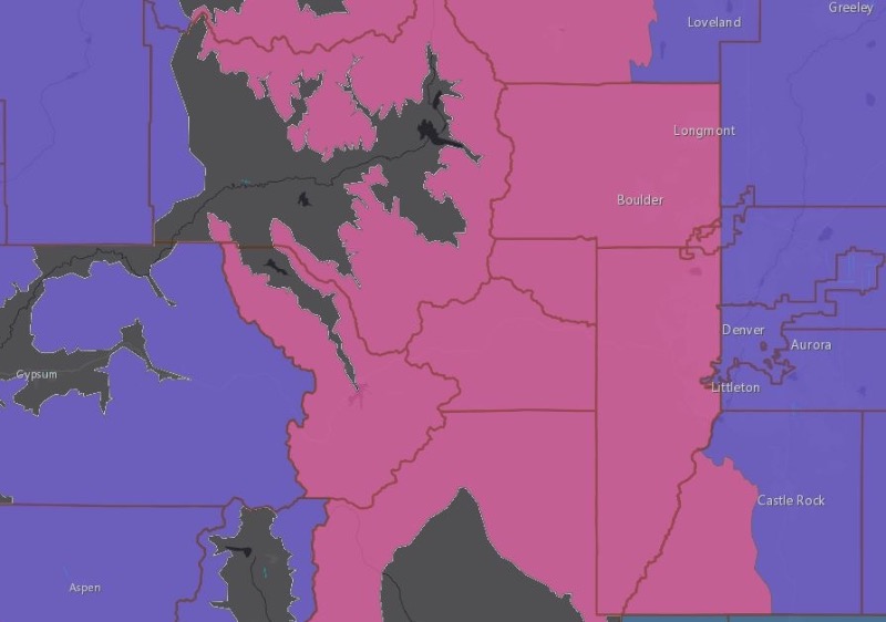
* WHAT...Heavy snow expected. Total snow accumulations of 6 to 12 inches. A light glaze of ice will be possible Monday morning.
* WHERE...The Northern Front Range Foothills and The Southern Front Range Foothills.
* WHEN...From 6 AM Monday to 6 AM MST Tuesday.
* IMPACTS...Travel could be very difficult. The hazardous conditions will impact the Monday evening commute and the Tuesday morning commute. The cold wind chills as low as 20 below zero could cause frostbite on exposed skin in as little as 30 minutes.
PRECAUTIONARY/PREPAREDNESS ACTIONS...
Slow down and use caution while traveling.
The latest road conditions for the state you are calling from can be obtained by calling 5 1 1.
URGENT - WINTER WEATHER MESSAGE
National Weather Service Denver CO
345 PM MST Sun Feb 2 2020
...COLD TEMPERATURES AND SNOW RETURNS MONDAY...
COZ033-034-030645-
/O.UPG.KBOU.WS.A.0001.200203T1900Z-200205T0100Z/
/O.NEW.KBOU.WS.W.0001.200203T1900Z-200204T1300Z/
Rocky Mountain National Park and the Medicine Bow Range-
The Mountains of Summit County, the Mosquito Range, and the Indian Peaks-
Including the cities of Cameron Pass, Laramie and Medicine Bow Mountains, Rabbit Ears Range, Rocky Mountain National Park, Willow Creek Pass, Berthoud Pass, Breckenridge, East Slopes Mosquito Range, East Slopes Southern Gore Range, l Eisenhower Tunnel, Indian Peaks, Kenosha Mountains, Mount Evans, Williams Fork Mountains, and Winter Park
345 PM MST Sun Feb 2 2020
...WINTER STORM WARNING IN EFFECT FROM NOON MONDAY TO 6 AM MST TUESDAY...
* WHAT...Heavy snow expected. Total snow accumulations of 6 to 12 inches, with the heaviest totals on the eastern slope of the Front Range. Valleys in Summit County will see lighter amounts of 3 to 6 inches. Winds gusting as high as 45 mph Monday, then diminishing.
* WHERE...Rocky Mountain National Park and the Medicine Bow Range and The Mountains of Summit County, the Mosquito Range, and the Indian Peaks.
* WHEN...From noon Monday to 6 AM MST Tuesday.
* IMPACTS...Travel could be very difficult. The hazardous conditions will impact the Monday evening commute and the Tuesday morning commute. The cold wind chills as low as 30 below zero could cause frostbite on exposed skin in as little as 30 minutes.
PRECAUTIONARY/PREPAREDNESS ACTIONS...
Slow down and use caution while traveling.
The latest road conditions for the state you are calling from can be obtained by calling 5 1 1.
URGENT - WINTER WEATHER l MESSAGE
National Weather Service Denver CO
345 PM MST Sun Feb 2 2020
...COLD TEMPERATURES AND SNOW RETURNS MONDAY...
COZ039-030645-
/O.NEW.KBOU.WS.W.0001.200203T1300Z-200204T1300Z/
Boulder and the western suburbs of Denver-
Including the cities of Arvada, Boulder, Golden, Lakewood, and Longmont
345 PM MST Sun Feb 2 2020
...WINTER STORM WARNING IN EFFECT FROM 6 AM MONDAY TO 6 AM MST TUESDAY...
* WHAT...Heavy snow expected. Total snow accumulations of 6 to 10 inches. A light glaze of ice will be possible Monday morning.
* WHERE...Boulder and the western suburbs of Denver.
* WHEN...From 6 AM Monday to 6 AM MST Tuesday.
* IMPACTS...Travel could be difficult. The hazardous conditions will impact the Monday evening commute and the Tuesday morning commute.
PRECAUTIONARY/PREPAREDNESS ACTIONS...
Slow down and use caution while traveling.
The latest road conditions for the state you are calling from can be obtained by calling 5 1 1.