My Mountain Town Weather Update from Chief Meteorologist Steve Hamilton:
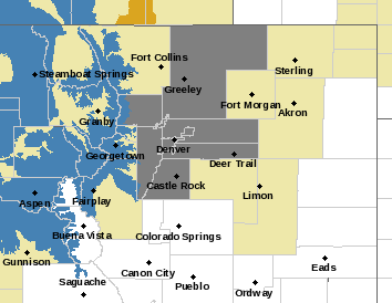
Here's the deal. A Winter Storm Watch is in effect for the mountains from late Saturday night through Monday afternoon. (Blue highlight on map.) Heavy snow is possible, with current predictions at 10" to 24", and wind gusts up to 50 mph. No watches are in effect for our foothills communities at this point. (We will update you if any are issued by NWS.)
Please plan on severe winter driving conditions if you are traveling into the CO mountains this weekend. For the foothills, we will likely see some snow from this system on Sunday, but not nearly as much as the mountains. We are working on snow total predictions, but at this point we can count on 2" to 6" by Monday morning.
mymountaintown.com/expert-local-weather
Winter Storm Watch
URGENT - WINTER WEATHER MESSAGE
National Weather Service Denver CO
406 PM MST Fri Feb 14 2020
...THE NEXT ROUND OF ALPINE SNOWFALL IS EXPECTED SATURDAY NIGHT INTO MONDAY...
.Strong moist northwest and westerly flow aloft will bring decent snows to the mountains of north central Colorado Saturday night well into Monday. The heaviest snow can be expected from Sunday afternoon through early Monday morning. Fairly strong winds will accompany the snow with gusts to 50 mph causing blowing and drifting snow. Winter driving conditions are expected.
COZ031-033-034-150715-
/O.NEW.KBOU.WS.A.0004.200216T0700Z-200218T0000Z/
Rabbit Ears Pass-
Rocky Mountain National Park and the Medicine Bow Range-
The Mountains of Summit County, the Mosquito Range, and the Indian Peaks-
Including the cities of East Slopes Park and Northern Gore Ranges, Gore Pass, Rabbit Ears Pass, Cameron Pass, Laramie and Medicine Bow Mountains, Rabbit Ears Range, Rocky Mountain National Park, Willow Creek Pass,
Berthoud Pass, Breckenridge, East Slopes Mosquito Range, East Slopes Southern Gore Range, Eisenhower Tunnel, Indian Peaks, Kenosha Mountains, Mount Evans, Williams Fork Mountains, and Winter Park
406 PM MST Fri Feb 14 2020
...
WINTER STORM WATCH IN EFFECT FROM LATE SATURDAY NIGHT THROUGH MONDAY AFTERNOON...
* WHAT...
Heavy snow possible. Total snow accumulations of 10 to 24 inches possible. Winds could gust as high as 50 mph.
* WHERE...Rabbit Ears Pass, Rocky Mountain National Park and the Medicine Bow Range and The Mountains of Summit County, the Mosquito Range, and the Indian Peaks.
* WHEN...From late Saturday night through Monday afternoon.
* IMPACTS...Travel could be very difficult to impossible. Areas of blowing snow could significantly reduce visibility. The hazardous conditions could impact the morning or evening commute. Gusty winds could bring down tree branches.
PRECAUTIONARY/PREPAREDNESS ACTIONS...
Monitor the latest forecasts for updates on this situation.
* * * * * * *
Air Quality Alert
COC013-123-001-031-059-035-005-014-152300-
Boulder-Weld-Adams-
Denver-Jefferson-Douglas-Arapahoe-Broomfield-
410 PM MST Fri Feb 14 2020
...
ACTION DAY FOR PARTICULATES FROM 400 PM FRIDAY UNTIL 400 PM SATURDAY...
The Colorado Department of Public Health and Environment has issued the following...
WHAT...Action Day for Particulates.
WHERE...Denver, Arapahoe, Jefferson, Douglas, Adams, Broomfield, Boulder and Weld Counties. Locations include, but are not limited to Denver, Boulder, Longmont, and Greeley.
WHEN...400 PM Friday February 14 to 400 PM Saturday February 15
IMPACTS...An Action Day for Particulates is now in effect for the seven-county Denver-Boulder metropolitan area. Requests to limit driving are now in effect until at least 4 PM Saturday, February 15, 2020. Limited mixing and ventilation has increased fine particulate concentrations across portions of the Northern Front Range Urban Corridor. Unhealthy for Sensitive Groups level fine particulate matter concentrations are possible on Friday, decreasing during the day Saturday, with Poor visibility is expected Saturday. For areas included in this advisory that are not expected to exceed the Unhealthy for Sensitive Groups (USG) air quality designation, we request that activities, such as driving, be reduced to lessen the impacts on neighboring air quality. Additional air pollution in this region may directly diminish air quality or contribute to precursors which may also adversely affect air quality. For Colorado air quality conditions, forecasts and advisories, visit:
www.colorado.gov/airquality/colorado_summary.aspx
HEALTH INFORMATION...Public Health Recommendations: Increasing likelihood of respiratory symptoms in sensitive individuals, aggravation of heart or lung disease and premature mortality in people with cardiopulmonary disease and older adults. People with heart or lung disease, older adults, and children should reduce prolonged or heavy exertion.