My Mountain Town Weather Update from Chief Meteorologist Steve Hamilton:
Winter Weather Advisory / Winter Storm Watch...
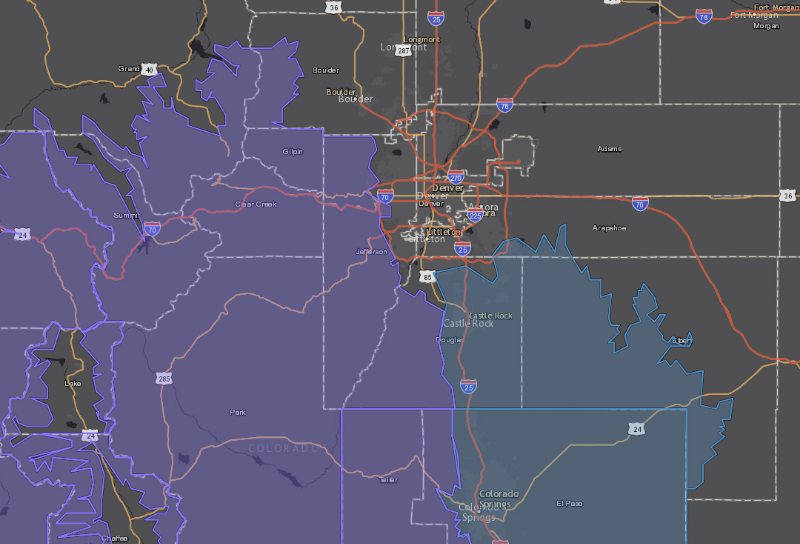
A Winter Weather Advisory (darker blue/purple; lighter blue is the Winter Storm Watch area) is in effect from 11 p.m. Saturday night, until 8 p.m. Sunday. 4 to 8 inches of snow will be possible, with road conditions likely to be icy/snow packed. Most of our foothills communities will be affected by low pressure, causing upslope conditions, and thus, snowfall. Prepare for winter driving conditions and longer travel times.
Check our interactive weather radar as the storm moves in, and find details for Morrison, Conifer, Evergreen, Pine, Bailey, Jefferson/Como, Alma, Fairplay, Hartsel, and Lake George/Guffey here:
mymountaintown.com/expert-local-weather
Check our 4 pages of webcams for current road and weather conditions:
Denver to Grant -
mymountaintown.com/weather-traffic
Jefferson to South Park -
mymountaintown.com/weather-traffic/285-w...ferson-to-south-park
I-70 Golden to Evergreen -
mymountaintown.com/weather-traffic/i-70-...-golden-to-evergreen
I-70 Evergreen to Eisenhower Tunnel -
mymountaintown.com/weather-traffic/i-70-...-and-traffic-cameras
Winter Weather Advisory
URGENT - WINTER WEATHER MESSAGE
National Weather Service Denver CO
326 AM MST Sat Feb 22 2020
COZ036-037-222230-
/O.NEW.KBOU.WW.Y.0012.200223T1200Z-200224T0300Z/
The Southern Front Range Foothills-South Park-
Including the cities of Bailey, Central City, Evergreen, Georgetown, Idaho Springs, Westcreek, Fairplay, Hartsel, Lake George, and South Park
326 AM MST Sat Feb 22 2020
...
WINTER WEATHER ADVISORY IN EFFECT FROM 5 AM TO 8 PM MST SUNDAY...
* WHAT...Snow expected.
Total snow accumulations of 4 to 8 inches.
* WHERE...The Southern Front Range Foothills and South Park.
* WHEN...From 5 AM to 8 PM MST Sunday.
* IMPACTS...Plan on slippery road conditions.
PRECAUTIONARY/PREPAREDNESS ACTIONS...
Slow down and use caution while traveling.
The latest road conditions for the state you are calling from can be obtained by calling 5 1 1.
* * * * * * * * * * * * * * * * * * * * * * * * * * * * * * * * * * *
URGENT - WINTER WEATHER MESSAGE
National Weather Service Denver CO
326 AM MST Sat Feb 22 2020
COZ034-222230-
/O.NEW.KBOU.WW.Y.0012.200223T0600Z-200224T0300Z/
The Mountains of Summit County, the Mosquito Range, and the Indian Peaks-
Including the cities of Berthoud Pass, Breckenridge, East Slopes Mosquito Range, East Slopes Southern Gore Range, Eisenhower Tunnel, Indian Peaks, Kenosha Mountains, Mount Evans, Williams Fork Mountains, and Winter Park
326 AM MST Sat Feb 22 2020
...
WINTER WEATHER ADVISORY IN EFFECT FROM 11 PM THIS EVENING TO 8 PM MST SUNDAY...
* WHAT...Snow expected. Total snow accumulations of 4 to 8 inches.
* WHERE...The Mountains of Summit County, the Mosquito Range, and the Indian Peaks.
* WHEN...From 11 PM this evening to 8 PM MST Sunday.
* IMPACTS...Plan on slippery road conditions.