- Posts: 9766
- Thank you received: 221
- Forum
- Life Up the Hill
- Scanner & Emergency Info, Weather Forecasts
- Winter Storm Warning & Watch March 18-20th
Winter Storm Warning & Watch March 18-20th
- MountainTownAlerts
-
 Topic Author
- Mountain Legend
-

Less
More
18 Mar 2020 12:04 #1
by MountainTownAlerts
Winter Storm Warning & Watch March 18-20th was created by MountainTownAlerts
From Chief Meteorlogist Steve Hamilton:
My Mountain Town Weather UPDATE: Winter Storm Warning...
A Winter Storm Warning will be in effect from 6:00 p.m. this evening until 6:00 a.m. Friday. A strong storm system will cross over Colorado during the next couple of days, setting up the foothills for a good chance of accumulating snow.
Travel will be difficult, with snow packed and icy roads and poor visibility. Travel into the mountains will be particularly hazardous with heavier accumulation expected.
mymountaintown.com/expert-local-weather
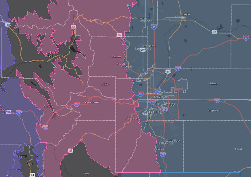
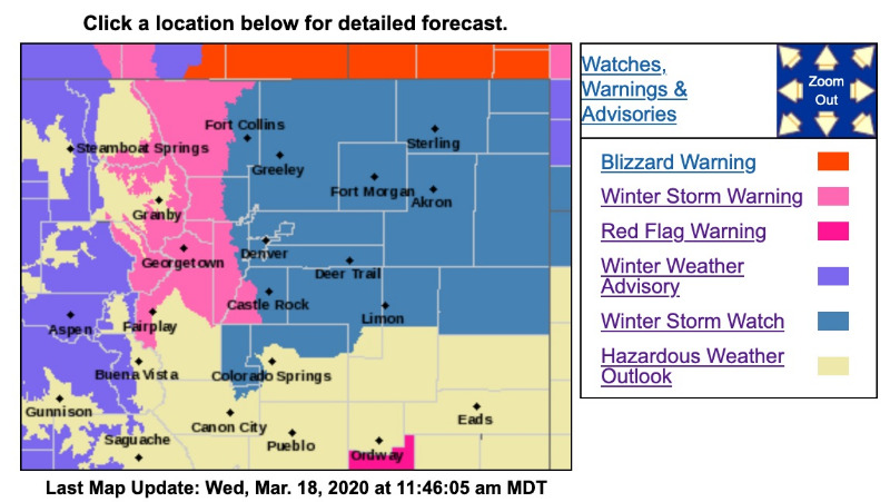
Winter Storm Warning - pink area on map
URGENT - WINTER WEATHER MESSAGE
National Weather Service Denver CO
502 AM MDT Wed Mar 18 2020
...SNOW AND STRONG WINDS TO IMPACT NORTH-CENTRAL AND NORTHEAST COLORADO TONIGHT THROUGH EARLY FRIDAY MORNING...
.A storm system moving over Colorado will bring moderate to heavy snowfall starting in the mountains tonight, then spreading over the plains Thursday morning into the afternoon. Winds gusting up to 45 mph across the plains will create hazardous travel conditions especially Thursday afternoon through Friday morning. The strongest winds will occur just east of I-25, while the heaviest snow may occur in and near the Front Range Foothills and Palmer Divide. Confidence on snow amounts as well as the temperatures across the plains is low, so will keep a Watch out.
Stay tuned to the National Weather Service for the latest updates regarding this storm.
COZ033-034-181915-
/O.UPG.KBOU.WS.A.0006.200319T0000Z-200320T1200Z/
/O.NEW.KBOU.WS.W.0004.200319T0000Z-200320T1200Z/
Rocky Mountain National Park and the Medicine Bow Range-
The Mountains of Summit County, the Mosquito Range, and the Indian Peaks-
Including the cities of Cameron Pass, Laramie and Medicine Bow Mountains, Rabbit Ears Range, Rocky Mountain National Park, Willow Creek Pass, Berthoud Pass, Breckenridge, East Slopes Mosquito Range, East Slopes Southern Gore Range, Eisenhower Tunnel, Indian Peaks, Kenosha Mountains, Mount Evans, Williams Fork Mountains, and Winter Park
502 AM MDT Wed Mar 18 2020
...WINTER STORM WARNING IN EFFECT FROM 6 PM THIS EVENING TO 6 AM MDT FRIDAY...
* WHAT...Heavy snow expected. Total snow accumulations of 9 to 18 inches.
* WHERE...Rocky Mountain National Park and the Medicine Bow Range and The Mountains of Summit County, the Mosquito Range, and the Indian Peaks.
* WHEN...From 6 PM this evening to 6 AM MDT Friday. Heaviest snow expected from 6 AM to 6 PM Thursday.
* IMPACTS...Travel could be very difficult to impossible. The hazardous conditions could impact the morning or evening commute.
PRECAUTIONARY/PREPAREDNESS ACTIONS...
If you must travel, keep an extra flashlight, food, and water in your vehicle in case of an emergency.
The latest road conditions for the state you are calling from can be obtained by calling 5 1 1.
URGENT - WINTER WEATHER MESSAGE
National Weather Service Denver CO
502 AM MDT Wed Mar 18 2020
COZ035-036-181915-
/O.UPG.KBOU.WS.A.0006.200319T0000Z-200320T1200Z/
/O.NEW.KBOU.WS.W.0004.200319T1200Z-200320T1200Z/
The Northern Front Range Foothills-
The Southern Front Range Foothills-
Including the cities of Estes Park, Glendevey, Nederland, Red Feather Lakes, Bailey, Central City, Evergreen, Georgetown, Idaho Springs, and Westcreek
502 AM MDT Wed Mar 18 2020
...WINTER STORM WARNING IN EFFECT FROM 6 AM THURSDAY TO 6 AM MDT FRIDAY...
* WHAT...Heavy snow expected. Total snow accumulations of 10 to 14 inches. Winds gusting as high as 35 mph.
* WHERE...The Northern Front Range Foothills and The Southern Front Range Foothills.
* WHEN...From 6 AM Thursday to 6 AM MDT Friday.
* IMPACTS...Travel could be very difficult. The hazardous conditions could impact the morning or evening commute.
* * * * * * * * * * * * * * * * * * * * * * * * * * * * * * * * * * * * * * * * * * * * * * * *
Winter Storm Watch - blue area on map
URGENT - WINTER WEATHER MESSAGE
National Weather Service Denver CO
502 AM MDT Wed Mar 18 2020
.A storm system moving over Colorado will bring moderate to heavy snowfall starting in the mountains tonight, then spreading over the plains Thursday morning into the afternoon. Winds gusting up to 45 mph across the plains will create hazardous travel conditions especially Thursday afternoon through Friday morning. The strongest winds will occur just east of I-25, while the heaviest snow may occur in and near the Front Range Foothills and Palmer Divide. Confidence on snow amounts as well as the temperatures across the plains is low, so will keep a Watch out.
Stay tuned to the National Weather Service for the latest updates regarding this storm.
COZ038>046-048>051-181915-
/O.CON.KBOU.WS.A.0006.200319T1600Z-200320T1200Z/
Fort Collins-Boulder and the western suburbs of Denver-Denver-
Castle Rock-Briggsdale-Greeley-Fort Morgan-Byers-Limon-Sterling-
Akron-Julesburg-Holyoke-
Including the cities of Fort Collins, Hereford, Loveland, Nunn, Arvada, Boulder, Golden, Lakewood, Longmont, Aurora, Brighton, City of Denver, Denver International Airport, Highlands Ranch, Littleton, Parker, Castle Rock, Elbert, Fondis, Kiowa, Larkspur, Briggsdale, Grover, Pawnee Buttes, Raymer, Stoneham, Eaton, Fort Lupton, Greeley, Roggen, Brush, Fort Morgan, Goodrich, Wiggins, Bennett, Byers, Deer Trail, Leader, Agate, Hugo, Limon, Matheson, Crook, Merino, Sterling, Peetz, Akron, Cope, Last Chance, Otis, Julesburg, Ovid, Sedgwick, Amherst, Haxtun, and Holyoke
502 AM MDT Wed Mar 18 2020
...WINTER STORM WATCH REMAINS IN EFFECT FROM THURSDAY MORNING THROUGH LATE THURSDAY NIGHT...
* WHAT...Heavy snow possible. Total snow accumulations of 3 to 7 inches possible. Winds could gust as high as 50 mph.
* WHERE...Portions of east central, north central and northeast Colorado.
* WHEN...From Thursday morning through late Thursday night.
* IMPACTS...Plan on slippery road conditions. Areas of blowing snow could significantly reduce visibility. The hazardous conditions could impact the evening commute.
* ADDITIONAL DETAILS...Drizzle and rain will develop after midnight tonight, then change over to heavy, wet snow from mid morning through the early afternoon hours.
My Mountain Town Weather UPDATE: Winter Storm Warning...
A Winter Storm Warning will be in effect from 6:00 p.m. this evening until 6:00 a.m. Friday. A strong storm system will cross over Colorado during the next couple of days, setting up the foothills for a good chance of accumulating snow.
Travel will be difficult, with snow packed and icy roads and poor visibility. Travel into the mountains will be particularly hazardous with heavier accumulation expected.
mymountaintown.com/expert-local-weather
Winter Storm Warning - pink area on map
URGENT - WINTER WEATHER MESSAGE
National Weather Service Denver CO
502 AM MDT Wed Mar 18 2020
...SNOW AND STRONG WINDS TO IMPACT NORTH-CENTRAL AND NORTHEAST COLORADO TONIGHT THROUGH EARLY FRIDAY MORNING...
.A storm system moving over Colorado will bring moderate to heavy snowfall starting in the mountains tonight, then spreading over the plains Thursday morning into the afternoon. Winds gusting up to 45 mph across the plains will create hazardous travel conditions especially Thursday afternoon through Friday morning. The strongest winds will occur just east of I-25, while the heaviest snow may occur in and near the Front Range Foothills and Palmer Divide. Confidence on snow amounts as well as the temperatures across the plains is low, so will keep a Watch out.
Stay tuned to the National Weather Service for the latest updates regarding this storm.
COZ033-034-181915-
/O.UPG.KBOU.WS.A.0006.200319T0000Z-200320T1200Z/
/O.NEW.KBOU.WS.W.0004.200319T0000Z-200320T1200Z/
Rocky Mountain National Park and the Medicine Bow Range-
The Mountains of Summit County, the Mosquito Range, and the Indian Peaks-
Including the cities of Cameron Pass, Laramie and Medicine Bow Mountains, Rabbit Ears Range, Rocky Mountain National Park, Willow Creek Pass, Berthoud Pass, Breckenridge, East Slopes Mosquito Range, East Slopes Southern Gore Range, Eisenhower Tunnel, Indian Peaks, Kenosha Mountains, Mount Evans, Williams Fork Mountains, and Winter Park
502 AM MDT Wed Mar 18 2020
...WINTER STORM WARNING IN EFFECT FROM 6 PM THIS EVENING TO 6 AM MDT FRIDAY...
* WHAT...Heavy snow expected. Total snow accumulations of 9 to 18 inches.
* WHERE...Rocky Mountain National Park and the Medicine Bow Range and The Mountains of Summit County, the Mosquito Range, and the Indian Peaks.
* WHEN...From 6 PM this evening to 6 AM MDT Friday. Heaviest snow expected from 6 AM to 6 PM Thursday.
* IMPACTS...Travel could be very difficult to impossible. The hazardous conditions could impact the morning or evening commute.
PRECAUTIONARY/PREPAREDNESS ACTIONS...
If you must travel, keep an extra flashlight, food, and water in your vehicle in case of an emergency.
The latest road conditions for the state you are calling from can be obtained by calling 5 1 1.
URGENT - WINTER WEATHER MESSAGE
National Weather Service Denver CO
502 AM MDT Wed Mar 18 2020
COZ035-036-181915-
/O.UPG.KBOU.WS.A.0006.200319T0000Z-200320T1200Z/
/O.NEW.KBOU.WS.W.0004.200319T1200Z-200320T1200Z/
The Northern Front Range Foothills-
The Southern Front Range Foothills-
Including the cities of Estes Park, Glendevey, Nederland, Red Feather Lakes, Bailey, Central City, Evergreen, Georgetown, Idaho Springs, and Westcreek
502 AM MDT Wed Mar 18 2020
...WINTER STORM WARNING IN EFFECT FROM 6 AM THURSDAY TO 6 AM MDT FRIDAY...
* WHAT...Heavy snow expected. Total snow accumulations of 10 to 14 inches. Winds gusting as high as 35 mph.
* WHERE...The Northern Front Range Foothills and The Southern Front Range Foothills.
* WHEN...From 6 AM Thursday to 6 AM MDT Friday.
* IMPACTS...Travel could be very difficult. The hazardous conditions could impact the morning or evening commute.
* * * * * * * * * * * * * * * * * * * * * * * * * * * * * * * * * * * * * * * * * * * * * * * *
Winter Storm Watch - blue area on map
URGENT - WINTER WEATHER MESSAGE
National Weather Service Denver CO
502 AM MDT Wed Mar 18 2020
.A storm system moving over Colorado will bring moderate to heavy snowfall starting in the mountains tonight, then spreading over the plains Thursday morning into the afternoon. Winds gusting up to 45 mph across the plains will create hazardous travel conditions especially Thursday afternoon through Friday morning. The strongest winds will occur just east of I-25, while the heaviest snow may occur in and near the Front Range Foothills and Palmer Divide. Confidence on snow amounts as well as the temperatures across the plains is low, so will keep a Watch out.
Stay tuned to the National Weather Service for the latest updates regarding this storm.
COZ038>046-048>051-181915-
/O.CON.KBOU.WS.A.0006.200319T1600Z-200320T1200Z/
Fort Collins-Boulder and the western suburbs of Denver-Denver-
Castle Rock-Briggsdale-Greeley-Fort Morgan-Byers-Limon-Sterling-
Akron-Julesburg-Holyoke-
Including the cities of Fort Collins, Hereford, Loveland, Nunn, Arvada, Boulder, Golden, Lakewood, Longmont, Aurora, Brighton, City of Denver, Denver International Airport, Highlands Ranch, Littleton, Parker, Castle Rock, Elbert, Fondis, Kiowa, Larkspur, Briggsdale, Grover, Pawnee Buttes, Raymer, Stoneham, Eaton, Fort Lupton, Greeley, Roggen, Brush, Fort Morgan, Goodrich, Wiggins, Bennett, Byers, Deer Trail, Leader, Agate, Hugo, Limon, Matheson, Crook, Merino, Sterling, Peetz, Akron, Cope, Last Chance, Otis, Julesburg, Ovid, Sedgwick, Amherst, Haxtun, and Holyoke
502 AM MDT Wed Mar 18 2020
...WINTER STORM WATCH REMAINS IN EFFECT FROM THURSDAY MORNING THROUGH LATE THURSDAY NIGHT...
* WHAT...Heavy snow possible. Total snow accumulations of 3 to 7 inches possible. Winds could gust as high as 50 mph.
* WHERE...Portions of east central, north central and northeast Colorado.
* WHEN...From Thursday morning through late Thursday night.
* IMPACTS...Plan on slippery road conditions. Areas of blowing snow could significantly reduce visibility. The hazardous conditions could impact the evening commute.
* ADDITIONAL DETAILS...Drizzle and rain will develop after midnight tonight, then change over to heavy, wet snow from mid morning through the early afternoon hours.
Please Log in or Create an account to join the conversation.
- Forum
- Life Up the Hill
- Scanner & Emergency Info, Weather Forecasts
- Winter Storm Warning & Watch March 18-20th
Time to create page: 0.171 seconds
sponsors


