From Chief Meteorologist Steve Hamilton:
Winter Weather Advisory For Most Of The Foothills...
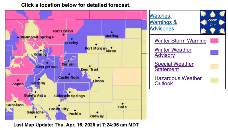
Some accumulating snow is expected for the Front Range Foothills, and the Denver metro area. The National Weather Service has posted a Winter Weather Advisory, in effect until Midnight Thursday night. A Winter Storm Warning is up for the mountains, and eastern Jefferson County. Colder air will move into the state on Thursday, with a decent amount of moisture available. The various forecast models have finally come into some agreement on the upslope conditions, which look favorable for a healthy dose of snow. Accumulations should stay under 10" for the foothills, but we can expect over 1 foot in the mountains. At this point, it looks like the snowy conditions will move out by Thursday night, but the weather pattern still looks unsettled Friday and Saturday, with lingering rain and snow showers, with temperatures getting a little bit of a boost.
mymountaintown.com/expert-local-weather
URGENT - WINTER WEATHER MESSAGE
National Weather Service Denver CO
105 AM MDT Thu Apr 16 2020
...SPRING SNOW STORM FOR NORTHERN COLORADO...
COZ038-039-161530-
/O.UPG.KBOU.WW.Y.0021.000000T0000Z-200417T0000Z/
/O.EXA.KBOU.WS.W.0005.000000T0000Z-200417T0000Z/
Fort Collins-Boulder and the
western suburbs of Denver-
Including the cities of Fort Collins, Hereford, Loveland, Nunn,
Arvada, Boulder, Golden, Lakewood, and Longmont
105 AM MDT Thu Apr 16 2020
...
WINTER STORM WARNING IN EFFECT UNTIL 6 PM MDT THIS EVENING...
* WHAT...
Heavy snow. Total snow accumulations of 6 to 12 inches.
* WHERE...Fort Collins and Boulder and the western suburbs of Denver.
* WHEN...Until 6 PM MDT this evening.
* IMPACTS...Travel could be very difficult due to snow cover and slushy roads. Heavy snow on tree branches could cause branches to break. The heavy snow on power lines and broken tree branches could lead to power outages.
PRECAUTIONARY/PREPAREDNESS ACTIONS...
If you must travel, keep an extra flashlight, food, and water in your vehicle in case of an emergency.
The latest road conditions for the state you are calling from can be obtained by calling 5 1 1.
* * * * * * * * * * * * * * * * * * * * * * * * * * * * * * * * * * * * * * * * * * * * * * * * *
URGENT - WINTER WEATHER MESSAGE
National Weather Service Denver CO
105 AM MDT Thu Apr 16 2020
...SPRING SNOW STORM FOR NORTHERN COLORADO...
COZ034-036-041-161530-
/O.CON.KBOU.WW.Y.0021.000000T0000Z-200417T0600Z/
The Mountains of Summit County, the Mosquito Range, and the Indian Peaks-
The Southern Front Range Foothills-Castle Rock-
Including the cities of Berthoud Pass,
Breckenridge, East Slopes Mosquito Range, East Slopes Southern Gore Range, Eisenhower Tunnel, Indian Peaks, Kenosha Mountains, Mount Evans, Williams Fork Mountains, Winter Park,
Bailey, Central City, Evergreen, Georgetown, Idaho Springs, Westcreek, Castle Rock, Elbert, Fondis, Kiowa, and Larkspur
105 AM MDT Thu Apr 16 2020
...
WINTER WEATHER ADVISORY REMAINS IN EFFECT UNTIL MIDNIGHT MDT TONIGHT...
* WHAT...
Snow. Total snow accumulations of 5 to 10 inches.
* WHERE...The Mountains of Summit County, the Mosquito Range, and the Indian Peaks, The Southern Front Range Foothills and Castle Rock.
* WHEN...Until midnight MDT tonight.
* IMPACTS...Travel could be very difficult. The hazardous conditions could impact the morning or evening commute.
PRECAUTIONARY/PREPAREDNESS ACTIONS...
Slow down and use caution while traveling.
The latest road conditions for the state you are calling from can be obtained by calling 5 1 1.