- Posts: 9766
- Thank you received: 221
- Forum
- Life Up the Hill
- Scanner & Emergency Info, Weather Forecasts
- Red Flag Warning, Fire Weather Watch for June 16, 2020
Red Flag Warning, Fire Weather Watch for June 16, 2020
- MountainTownAlerts
-
 Topic Author
- Mountain Legend
-

Less
More
15 Jun 2020 18:31 #1
by MountainTownAlerts
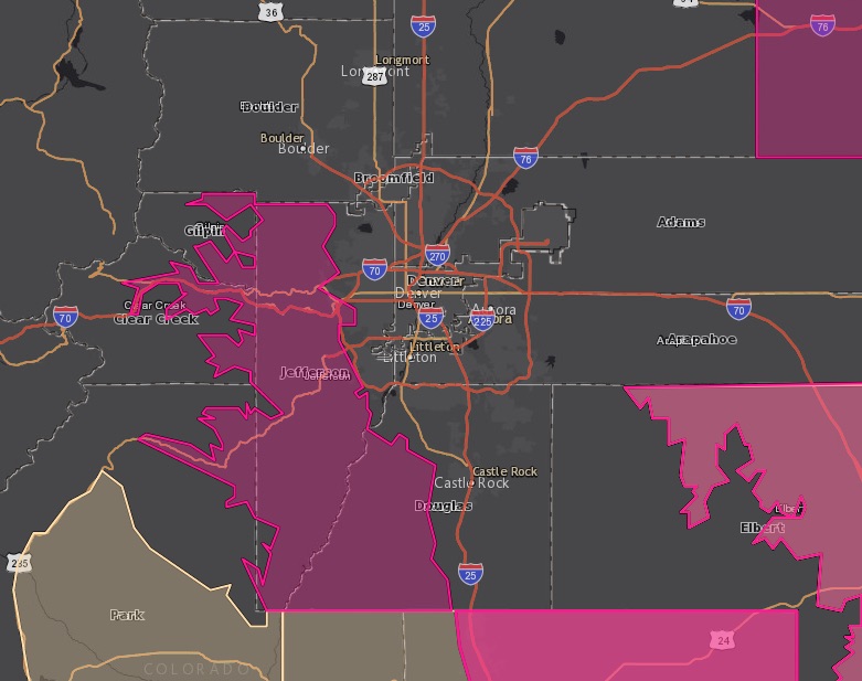
From Chief Meteorologist Steve Hamilton:
Colorado Front Range Foothills Weather: Red Flag Warning Tuesday. Red area on map indicates the area at risk for high forest fire danger. The beige area is being watched for similar conditions. Wind, low RH and high temperatures is bad juju for fire risk.
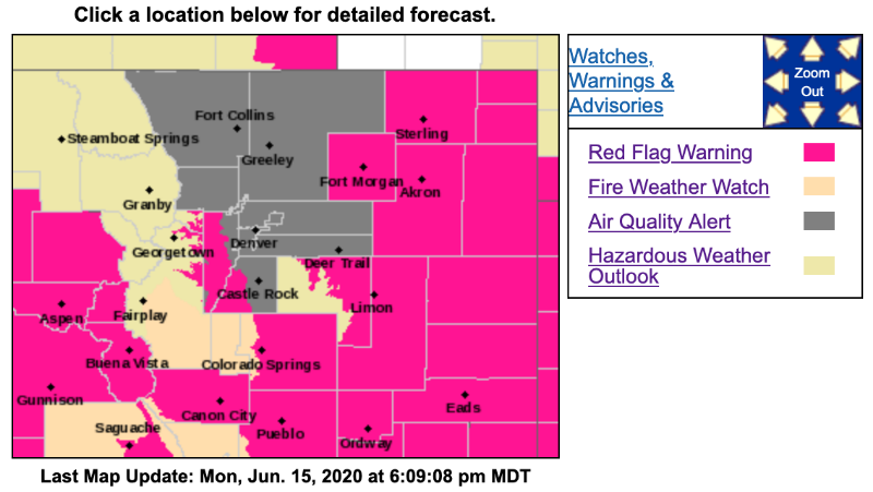
Red Flag Warning
URGENT - FIRE WEATHER MESSAGE
National Weather Service Denver/Boulder CO
354 PM MDT Mon Jun 15 2020
...HOT AND WINDY THE NEXT TWO AFTERNOONS...
.Hot weather and windy conditions in the afternoons will cause very high fire danger across portions of eastern Colorado in areas that have not had much recent rainfall. The winds will be strongest on the plains and in the southern Front Range foothills on Tuesday afternoon, along with humidities of 10 to 15 percent. On Wednesday, the winds will not be as strong, but it will be drier, with humidities as low as 8 percent. In the areas with greener grass, there is still potential for fires to move quickly due to the wind, but the fuel moisture will reduce this potential.
COZ216-161100-
/O.UPG.KBOU.FW.A.0008.200616T1800Z-200617T0200Z/
/O.NEW.KBOU.FW.W.0014.200616T1800Z-200617T0200Z/
Jefferson and West Douglas Counties Above 6000 Feet/
Gilpin/Clear Creek/Northeast Park Counties Below 9000 Feet-
354 PM MDT Mon Jun 15 2020
...RED FLAG WARNING IN EFFECT FROM NOON TO 8 PM MDT TUESDAY FOR WIND AND LOW RELATIVE HUMIDITY FOR FIRE ZONE 216...THE SOUTHERN FRONT RANGE FOOTHILLS...
The National Weather Service in Denver has issued a Red Flag Warning FOR WIND AND LOW RELATIVE HUMIDITY, which is in effect from noon to 8 PM MDT Tuesday. The Fire Weather Watch is no longer in effect.
* Affected Area...Fire Weather Zone 216.
* Winds...Southwest 10 to 20 mph with gusts up to 35 mph.
* Timing...Winds will peak in the mid to late afternoon. Conditions will improve in the evening.
* Relative Humidity...As low as 13 percent.
* Impacts...Conditions will be favorable for rapid rates of fire growth and spread.
PRECAUTIONARY/PREPAREDNESS ACTIONS...
A Red Flag Warning means that critical fire weather conditions are either occurring now....or will shortly. A combination of strong winds...low relative humidity...and warm temperatures can contribute to extreme fire behavior.
_ _ _ _ _ _ _ _
Fire Weather Watch
URGENT - FIRE WEATHER MESSAGE
National Weather Service Denver/Boulder CO
354 PM MDT Mon Jun 15 2020
...HOT AND WINDY THE NEXT TWO AFTERNOONS...
COZ214-161100-
/O.NEW.KBOU.FW.A.0009.200617T1800Z-200618T0200Z/
Central and Southeast Park County-
354 PM MDT Mon Jun 15 2020
...FIRE WEATHER WATCH IN EFFECT FROM WEDNESDAY AFTERNOON THROUGH WEDNESDAY EVENING FOR WIND AND LOW RELATIVE HUMIDITY FOR FIRE ZONE 214...SOUTH PARK...
The National Weather Service in Denver has issued a Fire Weather Watch FOR WIND AND LOW RELATIVE HUMIDITY, which is in effect from Wednesday afternoon through Wednesday evening.
* Affected Area...Fire Weather Zone 214.
* Winds...Southwest 10 to 15 mph with gusts up to 25 mph.
* Timing...Conditions will be worst Wednesday afternoon and improve Wednesday evening.
* Relative Humidity...As low as 11 percent.
* Impacts...Fires will start easily and spread rapidly.
PRECAUTIONARY/PREPAREDNESS ACTIONS...
A Fire Weather Watch means that critical fire weather conditions are forecast to occur. Listen for later forecasts and possible Red Flag Warnings.
_ _ _ _ _ _ _ _
Air Quality Alert
COC013-123-001-031-059-035-005-014-069-160600-
Boulder-Weld-Adams-Denver-Jefferson-Douglas-Arapahoe-Broomfield-Larimer-
410 PM MDT Mon Jun 15 2020
...OZONE ACTION DAY ALERT FROM 400 PM MONDAY UNTIL 1200 AM TUESDAY...
The Colorado Department of Public Health and Environment has issued the following...
WHAT...Ozone Action Day Alert.
WHERE...Douglas, Jefferson, Denver, western Arapahoe, western Adams, Broomfield, Boulder, Larimer, and Weld Counties
WHEN...400 PM Monday June 15 to 1200 AM Tuesday June 16
IMPACTS...Ozone Action Day Alert is now in effect for the Front Range Urban Corridor. Requests to limit driving of non-ZEV vehicles (i.e., gas or diesel) are now in effect until midnight, Monday night, June 15, 2020. Smoke from out-of-state wildfires is increasing ozone levels across the Northern Front Range Region, leading to Unhealthy for Sensitive Groups concentrations on Monday. Areas most likely with Unhealthy for Sensitive Groups concentrations are from the western suburbs of Denver northward to include Boulder, Longmont, and Ft. Collins. Conditions will improve overnight and Moderate Ozone levels are expected throughout the region on Tuesday.
HEALTH INFORMATION...Increasing likelihood of respiratory symptoms and breathing discomfort in active children and adults and people with lung disease, such as asthma. Active children and adults, and people with lung disease, such as asthma, should reduce prolonged or heavy outdoor exertion.
From Chief Meteorologist Steve Hamilton:
Colorado Front Range Foothills Weather: Red Flag Warning Tuesday. Red area on map indicates the area at risk for high forest fire danger. The beige area is being watched for similar conditions. Wind, low RH and high temperatures is bad juju for fire risk.
Red Flag Warning
URGENT - FIRE WEATHER MESSAGE
National Weather Service Denver/Boulder CO
354 PM MDT Mon Jun 15 2020
...HOT AND WINDY THE NEXT TWO AFTERNOONS...
.Hot weather and windy conditions in the afternoons will cause very high fire danger across portions of eastern Colorado in areas that have not had much recent rainfall. The winds will be strongest on the plains and in the southern Front Range foothills on Tuesday afternoon, along with humidities of 10 to 15 percent. On Wednesday, the winds will not be as strong, but it will be drier, with humidities as low as 8 percent. In the areas with greener grass, there is still potential for fires to move quickly due to the wind, but the fuel moisture will reduce this potential.
COZ216-161100-
/O.UPG.KBOU.FW.A.0008.200616T1800Z-200617T0200Z/
/O.NEW.KBOU.FW.W.0014.200616T1800Z-200617T0200Z/
Jefferson and West Douglas Counties Above 6000 Feet/
Gilpin/Clear Creek/Northeast Park Counties Below 9000 Feet-
354 PM MDT Mon Jun 15 2020
...RED FLAG WARNING IN EFFECT FROM NOON TO 8 PM MDT TUESDAY FOR WIND AND LOW RELATIVE HUMIDITY FOR FIRE ZONE 216...THE SOUTHERN FRONT RANGE FOOTHILLS...
The National Weather Service in Denver has issued a Red Flag Warning FOR WIND AND LOW RELATIVE HUMIDITY, which is in effect from noon to 8 PM MDT Tuesday. The Fire Weather Watch is no longer in effect.
* Affected Area...Fire Weather Zone 216.
* Winds...Southwest 10 to 20 mph with gusts up to 35 mph.
* Timing...Winds will peak in the mid to late afternoon. Conditions will improve in the evening.
* Relative Humidity...As low as 13 percent.
* Impacts...Conditions will be favorable for rapid rates of fire growth and spread.
PRECAUTIONARY/PREPAREDNESS ACTIONS...
A Red Flag Warning means that critical fire weather conditions are either occurring now....or will shortly. A combination of strong winds...low relative humidity...and warm temperatures can contribute to extreme fire behavior.
_ _ _ _ _ _ _ _
Fire Weather Watch
URGENT - FIRE WEATHER MESSAGE
National Weather Service Denver/Boulder CO
354 PM MDT Mon Jun 15 2020
...HOT AND WINDY THE NEXT TWO AFTERNOONS...
COZ214-161100-
/O.NEW.KBOU.FW.A.0009.200617T1800Z-200618T0200Z/
Central and Southeast Park County-
354 PM MDT Mon Jun 15 2020
...FIRE WEATHER WATCH IN EFFECT FROM WEDNESDAY AFTERNOON THROUGH WEDNESDAY EVENING FOR WIND AND LOW RELATIVE HUMIDITY FOR FIRE ZONE 214...SOUTH PARK...
The National Weather Service in Denver has issued a Fire Weather Watch FOR WIND AND LOW RELATIVE HUMIDITY, which is in effect from Wednesday afternoon through Wednesday evening.
* Affected Area...Fire Weather Zone 214.
* Winds...Southwest 10 to 15 mph with gusts up to 25 mph.
* Timing...Conditions will be worst Wednesday afternoon and improve Wednesday evening.
* Relative Humidity...As low as 11 percent.
* Impacts...Fires will start easily and spread rapidly.
PRECAUTIONARY/PREPAREDNESS ACTIONS...
A Fire Weather Watch means that critical fire weather conditions are forecast to occur. Listen for later forecasts and possible Red Flag Warnings.
_ _ _ _ _ _ _ _
Air Quality Alert
COC013-123-001-031-059-035-005-014-069-160600-
Boulder-Weld-Adams-Denver-Jefferson-Douglas-Arapahoe-Broomfield-Larimer-
410 PM MDT Mon Jun 15 2020
...OZONE ACTION DAY ALERT FROM 400 PM MONDAY UNTIL 1200 AM TUESDAY...
The Colorado Department of Public Health and Environment has issued the following...
WHAT...Ozone Action Day Alert.
WHERE...Douglas, Jefferson, Denver, western Arapahoe, western Adams, Broomfield, Boulder, Larimer, and Weld Counties
WHEN...400 PM Monday June 15 to 1200 AM Tuesday June 16
IMPACTS...Ozone Action Day Alert is now in effect for the Front Range Urban Corridor. Requests to limit driving of non-ZEV vehicles (i.e., gas or diesel) are now in effect until midnight, Monday night, June 15, 2020. Smoke from out-of-state wildfires is increasing ozone levels across the Northern Front Range Region, leading to Unhealthy for Sensitive Groups concentrations on Monday. Areas most likely with Unhealthy for Sensitive Groups concentrations are from the western suburbs of Denver northward to include Boulder, Longmont, and Ft. Collins. Conditions will improve overnight and Moderate Ozone levels are expected throughout the region on Tuesday.
HEALTH INFORMATION...Increasing likelihood of respiratory symptoms and breathing discomfort in active children and adults and people with lung disease, such as asthma. Active children and adults, and people with lung disease, such as asthma, should reduce prolonged or heavy outdoor exertion.
Please Log in or Create an account to join the conversation.
- MountainTownAlerts
-
Topic Author
- Mountain Legend
-
Less
More
- Posts: 9766
- Thank you received: 221
16 Jun 2020 09:19 #2
by MountainTownAlerts
Replied by MountainTownAlerts on topic Red Flag Warning, Fire Weather Watch for June 16, 2020
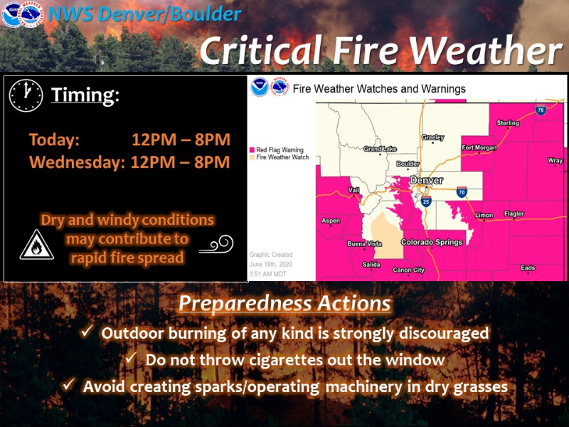
Unseasonably warm, dry and windy conditions will bring critical fire weather to parts of the forecast area where vegetation has been reported dry and susceptible to rapid fire spread from land management agencies. These conditions will occur this afternoon into early evening, and again Wednesday ahead of a cool front expected in the evening. The highest threat on Wednesday will be over South Park and Lincoln county.
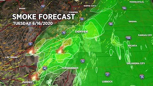
From Chris Tomer:
Where's the smoke coming from? A strong southwest wind is carrying smoke across Colorado from SW CO and AZ. The Magnum Fire in AZ is 29,500acres.
_ _ _ _ _ _ _ _ _ _ _ _ _ _ _ _ _ _ _ _ _ _
Red Flag Warning
URGENT - FIRE WEATHER MESSAGE
National Weather Service Denver/Boulder CO
349 AM MDT Tue Jun 16 2020
...HOT AND WINDY TODAY AND WEDNESDAY...
.Hot weather and windy conditions will cause critical fire danger across portions of eastern Colorado in areas that have not had much recent rainfall. The winds will be strongest on the plains and in the southern Front Range foothills this afternoon, along with humidities of 10 to 15 percent. On Wednesday, the winds will not be as strong, but it will be drier, with humidities as low as 8 percent. In the areas with greener grass, there is still potential for fires to move quickly due to the wind, but the fuel moisture will reduce this potential.
COZ216-244-248>251-161800-
/O.CON.KBOU.FW.W.0014.200616T1800Z-200617T0200Z/
Jefferson and West Douglas Counties Above 6000 Feet/
Gilpin/Clear Creek/Northeast Park Counties Below 9000 Feet-
Morgan County-Logan County-Washington County-Sedgwick County-Phillips County-
349 AM MDT Tue Jun 16 2020
...RED FLAG WARNING REMAINS IN EFFECT FROM NOON TODAY TO 8 PM MDT THIS EVENING FOR WIND AND LOW RELATIVE HUMIDITY FOR FIRE ZONES 244 AND 248 THROUGH 251...THE NORTHEAST COLORADO PLAINS...
* Affected Area...Fire Weather Zones 216...244...248...249...250 and 251.
* Winds...South 20 to 30 mph with gusts up to 40 mph.
* Timing...Conditions will be worst in the afternoon and improve during the early evening.
* Relative Humidity...As low as 10 percent.
* Impacts...Fires will start easily and spread rapidly.
PRECAUTIONARY/PREPAREDNESS ACTIONS...
A Red Flag Warning means that critical fire weather conditions are either occurring now....or will shortly. A combination of strong winds...low relative humidity...and warm temperatures can contribute to extreme fire behavior.
Please Log in or Create an account to join the conversation.
- Forum
- Life Up the Hill
- Scanner & Emergency Info, Weather Forecasts
- Red Flag Warning, Fire Weather Watch for June 16, 2020
Time to create page: 0.194 seconds
sponsors


