URGENT - FIRE WEATHER MESSAGE
National Weather Service Denver/Boulder CO
308 AM MDT Tue Jul 7 2020
...EXTENDED PERIOD OF HOT AND DRY CONDITIONS...
.A strong ridge of high pressure to our south combined with an increase in westerly flow aloft will bring higher fire danger to much of the area Tuesday and Wednesday. Winds will increase late Tuesday and remain gusty at times Wednesday. The winds will combine with much above normal temperatures and low humidity readings each day.
The hot and dry weather will remain in place through the weekend.
COZ211-213-214-217-071715-
/O.UPG.KBOU.FW.A.0012.200708T1600Z-200709T0200Z/
/O.NEW.KBOU.FW.W.0018.200708T1600Z-200709T0200Z/
/O.CON.KBOU.FW.W.0017.200707T1800Z-200708T0200Z/
Jackson County Below 9000 Feet-
Grand and
Summit Counties Below 9000 Feet-
Central and Southeast Park County-
West Jackson and West Grand Counties Above 9000 Feet-
308 AM MDT Tue Jul 7 2020
...
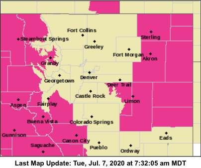
RED FLAG WARNING REMAINS IN EFFECT FROM NOON TODAY TO 8 PM MDT THIS EVENING FOR WIND AND LOW RELATIVE HUMIDITY FOR THE HIGH MOUNTAIN VALLEYS AND THE PARK AND NORTHERN GORE RANGES...
...RED FLAG WARNING IN EFFECT FROM 10 AM TO 8 PM MDT WEDNESDAY FOR WIND AND LOW RELATIVE HUMIDITY FOR THE HIGH MOUNTAIN VALLEYS AND THE PARK AND NORTHERN GORE RANGES...
The National Weather Service in Denver has issued a Red Flag Warning FOR WIND AND LOW RELATIVE HUMIDITY, which is in effect from 10 AM to 8 PM MDT Wednesday. The Fire Weather Watch is no longer in effect.
* Affected Area...Fire Weather Zones 211...213...214 and 217.
* Winds...Today, southwest 15 to 20 mph with gusts around 30 mph. On Wednesday, west 15 to 20 mph with gusts around 30 mph.
* Timing...Noon to 8 PM today. Wednesday will also see critical conditions, starting in the late morning and remaining in place through early evening.
* Relative Humidity...As low as 8 percent.
* Impacts...Conditions will be favorable for ignition and rapid growth and spread of fires.
PRECAUTIONARY/PREPAREDNESS ACTIONS...
A Red Flag Warning means that critical fire weather conditions are either occurring now....or will shortly. A combination of strong winds...low relative humidity...and warm temperatures can contribute to extreme fire behavior.