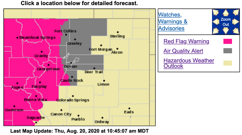
Red Flag Warning
URGENT - FIRE WEATHER MESSAGE
National Weather Service Denver/Boulder CO
343 AM MDT Thu Aug 20 2020
.Lightning and new fire starts, along with gusty outflow winds, will be the main concerns today. An increase in mid level moisture today will lead to an increase in shower and thunderstorm activity, only a few of which will produce wetting rains of one tenth to one quarter inch. Most areas will only see light if any rainfall. Given how dry the fuels are and receptive to burning, lightning may easily start new fires.
There will also be gusty outflow winds from the passing showers and storms. Most of these will be moving in from the west and northwest, so weather spotters will be essential today in giving a heads up to field crews. Peak gusts to 30 to 45 mph can be expected ahead of, and during any of the showers and storms today.
Moderate to good humidity recovery will finally occur tonight thanks to today`s increase in moisture and clearing skies/light winds tonight.
COZ211>213-215>218-201745-
/O.UPG.KBOU.FW.A.0014.200820T1800Z-200821T0300Z/
/O.NEW.KBOU.FW.W.0022.200820T1800Z-200821T0300Z/
Jackson County Below 9000 Feet-
South and Southeast Grand/West Central and Southwest Boulder/Gilpin/
Clear Creek/Summit/North and West Park Counties Above 9000 Feet-
Grand and Summit Counties Below 9000 Feet-
Larimer and Boulder Counties Between 6000 and 9000 Feet-
Jefferson and West Douglas Counties Above 6000 Feet/Gilpin/Clear Creek/Northeast Park Counties Below 9000 Feet-
West Jackson and West Grand Counties Above 9000 Feet-
South and East Jackson/Larimer/North and Northeast Grand/Northwest Boulder Counties Above 9000 Feet-
343 AM MDT Thu Aug 20 2020
...
RED FLAG WARNING IN EFFECT FROM NOON TODAY TO 9 PM MDT THIS EVENING FOR THUNDERSTORMS FOR FOR THE NORTHERN MOUNTAINS...FOOTHILLS...AND HIGH MOUNTAIN VALLEYS...
The National Weather Service in Denver has issued a
Red Flag Warning FOR THUNDERSTORMS, which is in effect from noon today to 9 PM MDT this evening. The Fire Weather Watch is no longer in effect.
* Affected Area...Fire Weather Zones 211...212...213...215...216...217 and 218.
* Winds...Northwest 10 to 15 mph. Variable and erratic wind gusts of 35 to 50 mph near showers and storms.
* Timing...Noon until 9 pm today.
* Impacts...Lightning and localized gusty winds from thunderstorms may cause new fire starts and rapid spread of fires.
* Thunderstorms...Scattered thunderstorms are expected to move over the mountains, high parks and foothills this afternoon and evening. A few of these storms may be dry or produce only light rainfall.
PRECAUTIONARY/PREPAREDNESS ACTIONS...
A Red Flag Warning means that critical fire weather conditions are either occurring now....or will shortly. A combination of dry fuels, thunderstorms, and gusty winds can contribute to new fire starts and extreme fire behavior.