- Posts: 9766
- Thank you received: 221
- Forum
- Life Up the Hill
- Scanner & Emergency Info, Weather Forecasts
- Winter Storm Warning Midnight Monday through Noon Wednesday
Winter Storm Warning Midnight Monday through Noon Wednesday
- MountainTownAlerts
-
 Topic Author
- Mountain Legend
-

Less
More
07 Sep 2020 12:31 #1
by MountainTownAlerts
My Mountain Town Weather from Chief Meteorologist Steve Hamilton: Winter Storm Warning
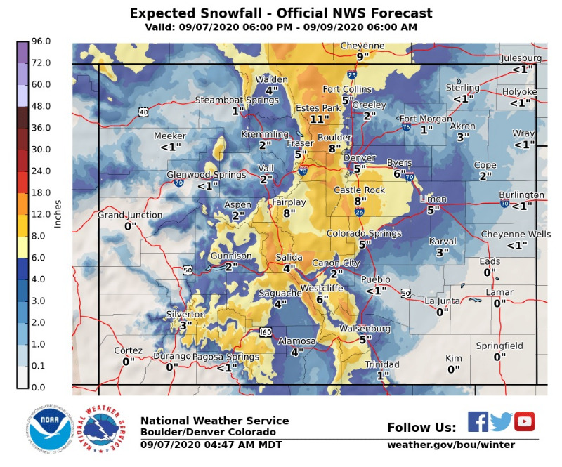
NWS has upgraded the foothills to a Winter Storm Warning, starting at midnight tonight, until Noon Wednesday. Snow, gusty wind and cold temperatures are expected. Here is a look at what NWS is figuring for snowfall totals. Please keep in mind that this is the total expected snowfall for the warning period... not what may be on the ground at any given time.
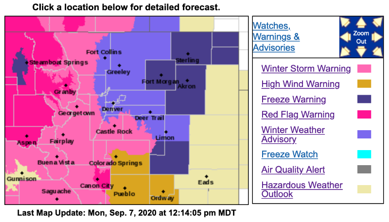
Outlines For Winter Storm Warning...
Red = Winter Storm Warning
Purple = Winter Weather Advisory
Expected snow totals are being updated on our website, where you can also follow the snow on our interactive radar:
mymountaintown.com/expert-local-weather
Winter Storm Warning
URGENT - WINTER WEATHER MESSAGE
National Weather Service Denver CO
339 AM MDT Mon Sep 7 2020
...MUCH COLDER TEMPERATURES WITH HEAVY SNOW POSSIBLE TUESDAY AND TUESDAY NIGHT...
.Winter will make an early arrival as a strong system from the north will bring much colder temperatures as well as accumulating snow to the region. Temperatures will drop quickly behind a cold front Monday evening with snow starting shortly after midnight over the higher terrain and foothills. Snow levels are expected to drop Tuesday morning, with accumulating snow possible for the Front Range, I-25 corridor and Metro areas. Snow falling on trees in full leaf may cause branches to break or other tree damage. Scattered power outages will also be possible. Roadways could become slippery and slushy especially across the higher terrain. The system will move out by late Wednesday with snowfall coming to an end and conditions improving.
COZ033>036-041-072100-
/O.UPG.KBOU.WS.A.0008.200908T0600Z-200909T1200Z/
/O.NEW.KBOU.WS.W.0006.200908T0600Z-200909T1800Z/
South and East Jackson/Larimer/North and Northeast Grand/Northwest Boulder Counties Above 9000 Feet-
South and Southeast Grand/West Central and Southwest Boulder/Gilpin/Clear Creek/Summit/North and West Park Counties Above 9000 Feet-
Larimer and Boulder Counties Between 6000 and 9000 Feet-
Jefferson and West Douglas Counties Above 6000 Feet/Gilpin/Clear Creek/Northeast Park Counties Below 9000 Feet-
Elbert/Central and East Douglas Counties Above 6000 Feet-
Including Cameron Pass, Laramie and Medicine Bow Mountains, Rabbit Ears Range, Rocky Mountain National Park, Willow Creek Pass, Berthoud Pass, Breckenridge, East Slopes Mosquito Range, East Slopes Southern Gore Range, Eisenhower Tunnel, Indian Peaks, Kenosha Mountains, Mount Evans, Williams Fork Mountains, Winter Park, Estes Park, Glendevey, Nederland, Red Feather Lakes, Bailey, Central City, Evergreen, Georgetown, Idaho Springs, Westcreek, Castle Rock, Elbert, Fondis, Kiowa, and Larkspur
339 AM MDT Mon Sep 7 2020
...WINTER STORM WARNING IN EFFECT FROM MIDNIGHT TONIGHT TO NOON MDT WEDNESDAY...
* WHAT...Heavy snow expected. Total snow accumulations of 9 to 15 inches, with winds gusting as high as 50 mph.
* WHERE...Rocky Mountain National Park and the Medicine Bow Range, The Mountains of Summit County, the Mosquito Range, and the Indian Peaks, The Front Range Foothills, and Palmer Divide including Castle Rock, Elbert, and Larkspur.
* WHEN...From midnight tonight to noon MDT Wednesday.
* IMPACTS...Travel could be very difficult. The hazardous conditions could impact the morning or evening commute. Gusty winds could bring down tree branches.
* ADDITIONAL DETAILS...Accumulating snow will impact area vegetation causing damage to trees and possible power outages. Roads could be slippery and slushy. Overnight low temperatures Tuesday night will drop into the teens and 20s.
PRECAUTIONARY/PREPAREDNESS ACTIONS...
If you must travel, keep an extra flashlight, food, and water in your vehicle in case of an emergency.
The latest road conditions for the state you are calling from can be obtained by calling 5 1 1.
_ _ _ _ _ _ _ _ _ _ _ _ _ _ _ _ _ _ _ _ _ _ _ _ _ _ _ _ _ _ _ _ _ _ _ _ _ _ _ _ _ _ _ _ _ _ _ _ _ _ _ _ _ _ _ _
URGENT - WINTER WEATHER MESSAGE
National Weather Service Denver CO
339 AM MDT Mon Sep 7 2020
...MUCH COLDER TEMPERATURES WITH HEAVY SNOW POSSIBLE TUESDAY AND TUESDAY NIGHT...
COZ037-072100-
/O.NEW.KBOU.WS.W.0006.200908T0600Z-200909T1800Z/
Central and Southeast Park County-
Including Fairplay, Hartsel, Lake George, and South Park
339 AM MDT Mon Sep 7 2020
...WINTER STORM WARNING IN EFFECT FROM MIDNIGHT TONIGHT TO NOON MDT WEDNESDAY...
* WHAT...Heavy snow expected. Total snow accumulations of 7 to 10 inches. Winds gusting as high as 35 mph.
* WHERE...South Park.
* WHEN...From midnight tonight to noon MDT Wednesday.
* IMPACTS...Travel could be very difficult. The hazardous conditions could impact the morning or evening commute.
* ADDITIONAL DETAILS...Accumulating snow will impact area vegetation causing damage to trees and possible power outages. Roads could be slippery and slushy. Overnight low temperatures Tuesday night will drop into the teens.
PRECAUTIONARY/PREPAREDNESS ACTIONS...
If you must travel, keep an extra flashlight, food, and water in your vehicle in case of an emergency.
The latest road conditions for the state you are calling from can be obtained by calling 5 1 1.
_ _ _ _ _ _ _ _ _ _ _ _ _ _ _ _ _ _ _ _ _ _ _ _ _ _ _ _ _ _ _ _ _ _ _ _ _ _ _ _ _ _ _ _ _ _ _ _ _ _ _ _ _ _ _ _
Winter Weather Advisory
URGENT - WINTER WEATHER MESSAGE
National Weather Service Denver CO
339 AM MDT Mon Sep 7 2020
...MUCH COLDER TEMPERATURES WITH HEAVY SNOW POSSIBLE TUESDAY AND TUESDAY NIGHT...
COZ038>040-043-072100-
/O.UPG.KBOU.WS.A.0008.200908T0600Z-200909T1200Z/
/O.NEW.KBOU.WW.Y.0023.200908T0600Z-200909T1800Z/
Larimer County Below 6000 Feet/Northwest Weld County-
Boulder And Jefferson Counties Below 6000 Feet/West Broomfield County-
North Douglas County Below 6000 Feet/Denver/West Adams and Arapahoe Counties/East Broomfield County-
Central and South Weld County-
Including Fort Collins, Hereford, Loveland, Nunn, Arvada, Boulder, Golden, Lakewood, Longmont, Aurora, Brighton, City of Denver, Denver International Airport, Highlands Ranch, Littleton, Parker, Eaton, Fort Lupton, Greeley, and Roggen
339 AM MDT Mon Sep 7 2020
...WINTER WEATHER ADVISORY IN EFFECT FROM MIDNIGHT TONIGHT TO NOON MDT WEDNESDAY...
* WHAT...Snow expected. Total snow accumulations of 3 to 7 inches by early Wednesday.
* WHERE...The Front Range Urban Corridor.
* WHEN...From midnight tonight to noon MDT Wednesday.
* IMPACTS...Travel could be very difficult. The hazardous conditions could impact the morning or evening commute.
* ADDITIONAL DETAILS...Accumulating snow will impact area vegetation causing damage to trees and possible power outages. Roads could be slippery and slushy for the Tuesday evening and Wednesday morning commutes. Overnight low temperatures Tuesday night will drop into the 20s.
PRECAUTIONARY/PREPAREDNESS ACTIONS...
Slow down and use caution while traveling.
The latest road conditions for the state you are calling from can be obtained by calling 5 1 1.
NWS has upgraded the foothills to a Winter Storm Warning, starting at midnight tonight, until Noon Wednesday. Snow, gusty wind and cold temperatures are expected. Here is a look at what NWS is figuring for snowfall totals. Please keep in mind that this is the total expected snowfall for the warning period... not what may be on the ground at any given time.
Outlines For Winter Storm Warning...
Red = Winter Storm Warning
Purple = Winter Weather Advisory
Expected snow totals are being updated on our website, where you can also follow the snow on our interactive radar:
mymountaintown.com/expert-local-weather
Winter Storm Warning
URGENT - WINTER WEATHER MESSAGE
National Weather Service Denver CO
339 AM MDT Mon Sep 7 2020
...MUCH COLDER TEMPERATURES WITH HEAVY SNOW POSSIBLE TUESDAY AND TUESDAY NIGHT...
.Winter will make an early arrival as a strong system from the north will bring much colder temperatures as well as accumulating snow to the region. Temperatures will drop quickly behind a cold front Monday evening with snow starting shortly after midnight over the higher terrain and foothills. Snow levels are expected to drop Tuesday morning, with accumulating snow possible for the Front Range, I-25 corridor and Metro areas. Snow falling on trees in full leaf may cause branches to break or other tree damage. Scattered power outages will also be possible. Roadways could become slippery and slushy especially across the higher terrain. The system will move out by late Wednesday with snowfall coming to an end and conditions improving.
COZ033>036-041-072100-
/O.UPG.KBOU.WS.A.0008.200908T0600Z-200909T1200Z/
/O.NEW.KBOU.WS.W.0006.200908T0600Z-200909T1800Z/
South and East Jackson/Larimer/North and Northeast Grand/Northwest Boulder Counties Above 9000 Feet-
South and Southeast Grand/West Central and Southwest Boulder/Gilpin/Clear Creek/Summit/North and West Park Counties Above 9000 Feet-
Larimer and Boulder Counties Between 6000 and 9000 Feet-
Jefferson and West Douglas Counties Above 6000 Feet/Gilpin/Clear Creek/Northeast Park Counties Below 9000 Feet-
Elbert/Central and East Douglas Counties Above 6000 Feet-
Including Cameron Pass, Laramie and Medicine Bow Mountains, Rabbit Ears Range, Rocky Mountain National Park, Willow Creek Pass, Berthoud Pass, Breckenridge, East Slopes Mosquito Range, East Slopes Southern Gore Range, Eisenhower Tunnel, Indian Peaks, Kenosha Mountains, Mount Evans, Williams Fork Mountains, Winter Park, Estes Park, Glendevey, Nederland, Red Feather Lakes, Bailey, Central City, Evergreen, Georgetown, Idaho Springs, Westcreek, Castle Rock, Elbert, Fondis, Kiowa, and Larkspur
339 AM MDT Mon Sep 7 2020
...WINTER STORM WARNING IN EFFECT FROM MIDNIGHT TONIGHT TO NOON MDT WEDNESDAY...
* WHAT...Heavy snow expected. Total snow accumulations of 9 to 15 inches, with winds gusting as high as 50 mph.
* WHERE...Rocky Mountain National Park and the Medicine Bow Range, The Mountains of Summit County, the Mosquito Range, and the Indian Peaks, The Front Range Foothills, and Palmer Divide including Castle Rock, Elbert, and Larkspur.
* WHEN...From midnight tonight to noon MDT Wednesday.
* IMPACTS...Travel could be very difficult. The hazardous conditions could impact the morning or evening commute. Gusty winds could bring down tree branches.
* ADDITIONAL DETAILS...Accumulating snow will impact area vegetation causing damage to trees and possible power outages. Roads could be slippery and slushy. Overnight low temperatures Tuesday night will drop into the teens and 20s.
PRECAUTIONARY/PREPAREDNESS ACTIONS...
If you must travel, keep an extra flashlight, food, and water in your vehicle in case of an emergency.
The latest road conditions for the state you are calling from can be obtained by calling 5 1 1.
_ _ _ _ _ _ _ _ _ _ _ _ _ _ _ _ _ _ _ _ _ _ _ _ _ _ _ _ _ _ _ _ _ _ _ _ _ _ _ _ _ _ _ _ _ _ _ _ _ _ _ _ _ _ _ _
URGENT - WINTER WEATHER MESSAGE
National Weather Service Denver CO
339 AM MDT Mon Sep 7 2020
...MUCH COLDER TEMPERATURES WITH HEAVY SNOW POSSIBLE TUESDAY AND TUESDAY NIGHT...
COZ037-072100-
/O.NEW.KBOU.WS.W.0006.200908T0600Z-200909T1800Z/
Central and Southeast Park County-
Including Fairplay, Hartsel, Lake George, and South Park
339 AM MDT Mon Sep 7 2020
...WINTER STORM WARNING IN EFFECT FROM MIDNIGHT TONIGHT TO NOON MDT WEDNESDAY...
* WHAT...Heavy snow expected. Total snow accumulations of 7 to 10 inches. Winds gusting as high as 35 mph.
* WHERE...South Park.
* WHEN...From midnight tonight to noon MDT Wednesday.
* IMPACTS...Travel could be very difficult. The hazardous conditions could impact the morning or evening commute.
* ADDITIONAL DETAILS...Accumulating snow will impact area vegetation causing damage to trees and possible power outages. Roads could be slippery and slushy. Overnight low temperatures Tuesday night will drop into the teens.
PRECAUTIONARY/PREPAREDNESS ACTIONS...
If you must travel, keep an extra flashlight, food, and water in your vehicle in case of an emergency.
The latest road conditions for the state you are calling from can be obtained by calling 5 1 1.
_ _ _ _ _ _ _ _ _ _ _ _ _ _ _ _ _ _ _ _ _ _ _ _ _ _ _ _ _ _ _ _ _ _ _ _ _ _ _ _ _ _ _ _ _ _ _ _ _ _ _ _ _ _ _ _
Winter Weather Advisory
URGENT - WINTER WEATHER MESSAGE
National Weather Service Denver CO
339 AM MDT Mon Sep 7 2020
...MUCH COLDER TEMPERATURES WITH HEAVY SNOW POSSIBLE TUESDAY AND TUESDAY NIGHT...
COZ038>040-043-072100-
/O.UPG.KBOU.WS.A.0008.200908T0600Z-200909T1200Z/
/O.NEW.KBOU.WW.Y.0023.200908T0600Z-200909T1800Z/
Larimer County Below 6000 Feet/Northwest Weld County-
Boulder And Jefferson Counties Below 6000 Feet/West Broomfield County-
North Douglas County Below 6000 Feet/Denver/West Adams and Arapahoe Counties/East Broomfield County-
Central and South Weld County-
Including Fort Collins, Hereford, Loveland, Nunn, Arvada, Boulder, Golden, Lakewood, Longmont, Aurora, Brighton, City of Denver, Denver International Airport, Highlands Ranch, Littleton, Parker, Eaton, Fort Lupton, Greeley, and Roggen
339 AM MDT Mon Sep 7 2020
...WINTER WEATHER ADVISORY IN EFFECT FROM MIDNIGHT TONIGHT TO NOON MDT WEDNESDAY...
* WHAT...Snow expected. Total snow accumulations of 3 to 7 inches by early Wednesday.
* WHERE...The Front Range Urban Corridor.
* WHEN...From midnight tonight to noon MDT Wednesday.
* IMPACTS...Travel could be very difficult. The hazardous conditions could impact the morning or evening commute.
* ADDITIONAL DETAILS...Accumulating snow will impact area vegetation causing damage to trees and possible power outages. Roads could be slippery and slushy for the Tuesday evening and Wednesday morning commutes. Overnight low temperatures Tuesday night will drop into the 20s.
PRECAUTIONARY/PREPAREDNESS ACTIONS...
Slow down and use caution while traveling.
The latest road conditions for the state you are calling from can be obtained by calling 5 1 1.
Please Log in or Create an account to join the conversation.
- Forum
- Life Up the Hill
- Scanner & Emergency Info, Weather Forecasts
- Winter Storm Warning Midnight Monday through Noon Wednesday
Time to create page: 0.167 seconds
sponsors


