- Posts: 9766
- Thank you received: 221
- Forum
- Life Up the Hill
- Scanner & Emergency Info, Weather Forecasts
- Red Flag Warning for September 25, 2020
Red Flag Warning for September 25, 2020
- MountainTownAlerts
-
 Topic Author
- Mountain Legend
-

Less
More
24 Sep 2020 09:01 #1
by MountainTownAlerts
URGENT - FIRE WEATHER MESSAGE
National Weather Service Denver/Boulder CO
406 AM MDT Thu Sep 24 2020
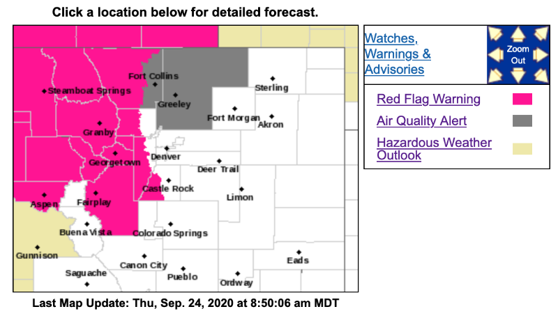
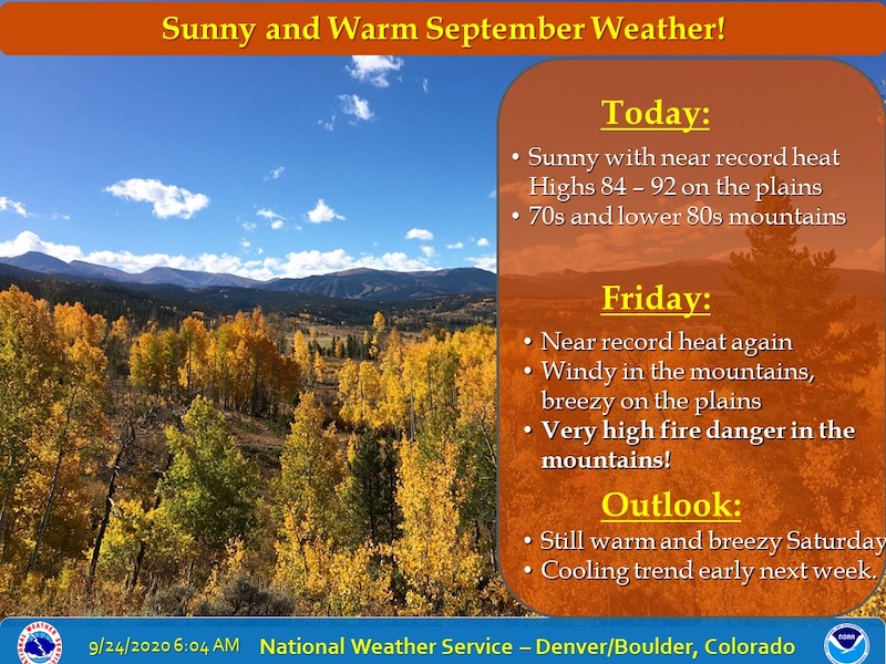
Very warm and dry conditions are expected Friday afternoon. A powerful storm system well north of Colorado will increase west winds across the northern half of Colorado throughout the afternoon and evening hours. Red flag conditions are expected Friday afternoon for strong winds and low relative humidity. The strongest winds and driest conditions are expected east of the Divide across Larimer County, though favorable conditions for rapid fire growth are possible across all of the warned area.
COZ212-214-216-241815-
/O.NEW.KBOU.FW.W.0025.200925T1800Z-200926T0200Z/
South and Southeast Grand/West Central and Southwest Boulder/Gilpin/Clear Creek/Summit/North and West Park Counties Above 9000 Feet-
Central and Southeast Park County-
Jefferson and West Douglas Counties Above 6000 Feet/Gilpin/Clear Creek/Northeast Park Counties Below 9000 Feet-
406 AM MDT Thu Sep 24 2020
...RED FLAG WARNING IN EFFECT FROM NOON TO 8 PM MDT FRIDAY FOR WIND AND LOW RELATIVE HUMIDITY FOR THE CENTRAL MOUNTAINS, HIGH MOUNTAIN VALLEYS, AND SOUTHERN FRONT RANGE FOOTHILLS...
The National Weather Service in Denver has issued a Red Flag Warning FOR WIND AND LOW RELATIVE HUMIDITY, which is in effect from noon to 8 PM MDT Friday.
* Affected Area...Fire Weather Zones 212, 214 and 216.
* Timing...12 PM through 8 PM Friday.
* Winds...West 10 to 20 mph with gusts up to 35 mph.
* Relative Humidity...As low as 12 percent.
* Impacts...Rapid growth of existing fires and new fire starts will be possible due to the gusty winds and very low humidity.
PRECAUTIONARY/PREPAREDNESS ACTIONS...
A Red Flag Warning means that critical fire weather conditions are either occurring now....or will shortly. A combination of strong winds...low relative humidity...and warm temperatures can contribute to extreme fire behavior.
Red Flag Warning for September 25, 2020 was created by MountainTownAlerts
URGENT - FIRE WEATHER MESSAGE
National Weather Service Denver/Boulder CO
406 AM MDT Thu Sep 24 2020
Very warm and dry conditions are expected Friday afternoon. A powerful storm system well north of Colorado will increase west winds across the northern half of Colorado throughout the afternoon and evening hours. Red flag conditions are expected Friday afternoon for strong winds and low relative humidity. The strongest winds and driest conditions are expected east of the Divide across Larimer County, though favorable conditions for rapid fire growth are possible across all of the warned area.
COZ212-214-216-241815-
/O.NEW.KBOU.FW.W.0025.200925T1800Z-200926T0200Z/
South and Southeast Grand/West Central and Southwest Boulder/Gilpin/Clear Creek/Summit/North and West Park Counties Above 9000 Feet-
Central and Southeast Park County-
Jefferson and West Douglas Counties Above 6000 Feet/Gilpin/Clear Creek/Northeast Park Counties Below 9000 Feet-
406 AM MDT Thu Sep 24 2020
...RED FLAG WARNING IN EFFECT FROM NOON TO 8 PM MDT FRIDAY FOR WIND AND LOW RELATIVE HUMIDITY FOR THE CENTRAL MOUNTAINS, HIGH MOUNTAIN VALLEYS, AND SOUTHERN FRONT RANGE FOOTHILLS...
The National Weather Service in Denver has issued a Red Flag Warning FOR WIND AND LOW RELATIVE HUMIDITY, which is in effect from noon to 8 PM MDT Friday.
* Affected Area...Fire Weather Zones 212, 214 and 216.
* Timing...12 PM through 8 PM Friday.
* Winds...West 10 to 20 mph with gusts up to 35 mph.
* Relative Humidity...As low as 12 percent.
* Impacts...Rapid growth of existing fires and new fire starts will be possible due to the gusty winds and very low humidity.
PRECAUTIONARY/PREPAREDNESS ACTIONS...
A Red Flag Warning means that critical fire weather conditions are either occurring now....or will shortly. A combination of strong winds...low relative humidity...and warm temperatures can contribute to extreme fire behavior.
Please Log in or Create an account to join the conversation.
- MountainTownAlerts
-
Topic Author
- Mountain Legend
-
Less
More
- Posts: 9766
- Thank you received: 221
24 Sep 2020 09:25 #2
by MountainTownAlerts
Replied by MountainTownAlerts on topic Red Flag Warning for September 25, 2020
Please Log in or Create an account to join the conversation.
- MountainTownAlerts
-
Topic Author
- Mountain Legend
-
Less
More
- Posts: 9766
- Thank you received: 221
25 Sep 2020 08:05 #3
by MountainTownAlerts
Red Flag Warning
URGENT - FIRE WEATHER MESSAGE
National Weather Service Denver/Boulder CO
414 AM MDT Fri Sep 25 2020
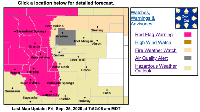
Very warm and dry conditions are expected Friday and Saturday afternoons. A powerful storm system well north of Colorado will increase west winds across the northern half of Colorado throughout the afternoon and evening hours. Red flag conditions are expected Friday afternoon for strong winds and low relative humidity. The strongest winds and driest conditions are expected east of the Divide across Larimer County, though favorable conditions for rapid fire growth are possible across all of the warned area.
Strong winds will again occur on Saturday afternoon, this time spreading across the plains along the Wyoming border. Relative humidity looks to be low enough for a fire weather watch. Across the high country, winds will be strong with gusts to 35 mph, but relative humidity values are for now expected to remain above 15 percent in those areas.
COZ211>218-251815-
/O.CON.KBOU.FW.W.0025.200925T1800Z-200926T0200Z/
Jackson County Below 9000 Feet-
South and Southeast Grand/West Central and Southwest Boulder/Gilpin/Clear Creek/Summit/North and West Park Counties Above 9000 Feet-
Grand and Summit Counties Below 9000 Feet-
Central and Southeast Park County-
Larimer and Boulder Counties Between 6000 and 9000 Feet-
Jefferson and West Douglas Counties Above 6000 Feet/Gilpin/Clear Creek/Northeast Park Counties Below 9000 Feet-
West Jackson and West Grand Counties Above 9000 Feet-
South and East Jackson/Larimer/North and Northeast Grand/Northwest Boulder Counties Above 9000 Feet-
414 AM MDT Fri Sep 25 2020
...RED FLAG WARNING REMAINS IN EFFECT FROM NOON TODAY TO 8 PM MDT THIS EVENING FOR WIND AND LOW RELATIVE HUMIDITY FOR THE NORTHERN MOUNTAINS, HIGH MOUNTAIN VALLEYS, AND NORTHERN FRONT RANGE FOOTHILLS. FIRE WEATHER ZONES 211-218...
* Affected Area...Fire Weather Zones 211, 212, 213, 214, 215, 216, 217 and 218.
* Timing...12 PM through 8 PM Friday.
* Winds...West 15 to 25 mph with gusts up to 40 mph.
* Relative Humidity...As low as 12 percent.
* Impacts...Rapid growth of existing fires and new fire starts will be possible due to the gusty winds and very low humidity.
PRECAUTIONARY/PREPAREDNESS ACTIONS...
A Red Flag Warning means that critical fire weather conditions are either occurring now....or will shortly. A combination of strong winds...low relative humidity...and warm temperatures can contribute to extreme fire behavior.
Replied by MountainTownAlerts on topic Red Flag Warning for September 25, 2020
Red Flag Warning
URGENT - FIRE WEATHER MESSAGE
National Weather Service Denver/Boulder CO
414 AM MDT Fri Sep 25 2020
Very warm and dry conditions are expected Friday and Saturday afternoons. A powerful storm system well north of Colorado will increase west winds across the northern half of Colorado throughout the afternoon and evening hours. Red flag conditions are expected Friday afternoon for strong winds and low relative humidity. The strongest winds and driest conditions are expected east of the Divide across Larimer County, though favorable conditions for rapid fire growth are possible across all of the warned area.
Strong winds will again occur on Saturday afternoon, this time spreading across the plains along the Wyoming border. Relative humidity looks to be low enough for a fire weather watch. Across the high country, winds will be strong with gusts to 35 mph, but relative humidity values are for now expected to remain above 15 percent in those areas.
COZ211>218-251815-
/O.CON.KBOU.FW.W.0025.200925T1800Z-200926T0200Z/
Jackson County Below 9000 Feet-
South and Southeast Grand/West Central and Southwest Boulder/Gilpin/Clear Creek/Summit/North and West Park Counties Above 9000 Feet-
Grand and Summit Counties Below 9000 Feet-
Central and Southeast Park County-
Larimer and Boulder Counties Between 6000 and 9000 Feet-
Jefferson and West Douglas Counties Above 6000 Feet/Gilpin/Clear Creek/Northeast Park Counties Below 9000 Feet-
West Jackson and West Grand Counties Above 9000 Feet-
South and East Jackson/Larimer/North and Northeast Grand/Northwest Boulder Counties Above 9000 Feet-
414 AM MDT Fri Sep 25 2020
...RED FLAG WARNING REMAINS IN EFFECT FROM NOON TODAY TO 8 PM MDT THIS EVENING FOR WIND AND LOW RELATIVE HUMIDITY FOR THE NORTHERN MOUNTAINS, HIGH MOUNTAIN VALLEYS, AND NORTHERN FRONT RANGE FOOTHILLS. FIRE WEATHER ZONES 211-218...
* Affected Area...Fire Weather Zones 211, 212, 213, 214, 215, 216, 217 and 218.
* Timing...12 PM through 8 PM Friday.
* Winds...West 15 to 25 mph with gusts up to 40 mph.
* Relative Humidity...As low as 12 percent.
* Impacts...Rapid growth of existing fires and new fire starts will be possible due to the gusty winds and very low humidity.
PRECAUTIONARY/PREPAREDNESS ACTIONS...
A Red Flag Warning means that critical fire weather conditions are either occurring now....or will shortly. A combination of strong winds...low relative humidity...and warm temperatures can contribute to extreme fire behavior.
Please Log in or Create an account to join the conversation.
- Forum
- Life Up the Hill
- Scanner & Emergency Info, Weather Forecasts
- Red Flag Warning for September 25, 2020
Time to create page: 0.195 seconds
sponsors


