- Posts: 9766
- Thank you received: 221
- Forum
- Life Up the Hill
- Scanner & Emergency Info, Weather Forecasts
- Red Flag Warning for October 11; High Fire Danger Today & Next Week
Red Flag Warning for October 11; High Fire Danger Today & Next Week
- MountainTownAlerts
-
 Topic Author
- Mountain Legend
-

Less
More
10 Oct 2020 09:16 #1
by MountainTownAlerts
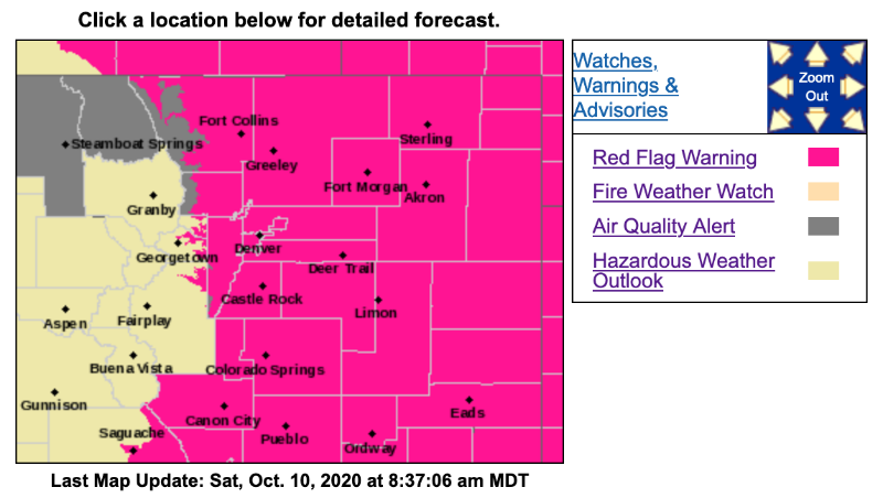
URGENT - FIRE WEATHER MESSAGE
National Weather Service Denver/Boulder CO
344 AM MDT Sat Oct 10 2020
...RED FLAG WARNING FOR THE NORTHEAST COLORADO PLAINS THIS AFTERNOON...
...RED FLAG WARNING FOR STRONGER WINDS OVER THE FOOTHILLS AND PLAINS SUNDAY...
.Continued hot, very dry, and breezy conditions ahead of an approaching storm system will lead to critical fire weather across the plains of northeast and east central Colorado this afternoon.
Strong winds are expected over the northern Colorado mountains and foothills late tonight into Sunday. Very windy conditions will spread across the plains by Sunday afternoon behind a pacific cold front.
COZ215-216-101745-
/O.UPG.KBOU.FW.A.0021.201011T0900Z-201012T0000Z/
/O.NEW.KBOU.FW.W.0030.201011T0900Z-201012T0000Z/
Larimer and Boulder Counties Between 6000 and 9000 Feet-
Jefferson and West Douglas Counties Above 6000 Feet/Gilpin/Clear Creek/Northeast Park Counties Below 9000 Feet-
344 AM MDT Sat Oct 10 2020
...RED FLAG WARNING IN EFFECT FROM 3 AM TO 6 PM MDT SUNDAY FOR WIND AND LOW RELATIVE HUMIDITY FOR THE FOOTHILLS...FIRE WEATHER ZONES 215 AND 216...
The National Weather Service in Denver has issued a Red Flag Warning FOR WIND AND LOW RELATIVE HUMIDITY, which is in effect from 3 AM to 6 PM MDT Sunday. The Fire Weather Watch is no longer in effect.
* Affected Area...Fire Weather Zones 215 and 216.
* Timing...strong winds will develop early Sunday morning and continue into Sunday night.
* Winds...West 25 to 35 mph with gusts up to 55 mph.
* Relative Humidity...As low as 18 percent.
PRECAUTIONARY/PREPAREDNESS ACTIONS...
A Red Flag Warning means that critical fire weather conditions are either occurring now....or will shortly. A combination of strong winds...low relative humidity...and warm temperatures can contribute to extreme fire behavior.
_ _ _ _ _ _ _ _ _ _ _ _ _ _ _ _ _ _ _ _ _ _ _ _ _ _ _ _ _ _ _ _ _ _ _ _ _ _ _ _ _ _
Hazardous Weather Outlook
Hazardous Weather Outlook
National Weather Service Denver/Boulder CO
354 AM MDT Sat Oct 10 2020
COZ030>051-111000-
Jackson County Below 9000 Feet-
West Jackson and West Grand Counties Above 9000 Feet-
Grand and Summit Counties Below 9000 Feet-
South and East Jackson/Larimer/North and Northeast Grand/
Northwest Boulder Counties Above 9000 Feet-
South and Southeast Grand/West Central and Southwest Boulder/
Gilpin/Clear Creek/Summit/North and West Park Counties Above 9000 Feet-
Larimer and Boulder Counties Between 6000 and 9000 Feet-
Jefferson and West Douglas Counties Above 6000 Feet/Gilpin/Clear Creek/Northeast Park Counties Below 9000 Feet-
Central and Southeast Park County-
Larimer County Below 6000 Feet/Northwest Weld County-
Boulder And Jefferson Counties Below 6000 Feet/West Broomfield County-
North Douglas County Below 6000 Feet/Denver/West Adams and Arapahoe Counties/East Broomfield County-
Elbert/Central and East Douglas Counties Above 6000 Feet-
Northeast Weld County-Central and South Weld County-Morgan County-
Central and East Adams and Arapahoe Counties-
North and Northeast Elbert County Below 6000 Feet/North Lincoln County-
Southeast Elbert County Below 6000 Feet/South Lincoln County-
Logan County-Washington County-Sedgwick County-Phillips County-
354 AM MDT Sat Oct 10 2020
...STRONGER WINDS WILL PRODUCE EXTREME FIRE DANGER THIS WEEKEND...
This hazardous weather outlook is for northeast and north central Colorado.
.DAY ONE...Today and Tonight
Very dry and unseasonably warm weather will continue across the region this afternoon. In addition, gusty southerly winds will increase across the plains this afternoon resulting in very high to extreme fire danger. Late tonight, gusty westerly winds up to 65 mph will be possible in the mountains and higher foothills.
.DAYS TWO THROUGH SEVEN...Sunday through Friday
Critical fire danger will continue on Sunday, from the foothills across the plains, as winds increase across the area. Winds will gust from 55 to 65 mph over the higher terrain, and from 45 to 55 mph across the plains, by afternoon. Meanwhile, rain and snow showers will become widespread over the mountains with 2 to 4 inches of snow above 10000 feet.
For Monday through Wednesday, it will be dry with very windy conditions over the higher terrain. Elevated fire danger will continue in the foothills and across the plains near the Wyoming border.
.SPOTTER INFORMATION STATEMENT...
Spotter activation will not be needed today or tonight.
Red Flag Warning for October 11; High Fire Danger Today & Next Week was created by MountainTownAlerts
URGENT - FIRE WEATHER MESSAGE
National Weather Service Denver/Boulder CO
344 AM MDT Sat Oct 10 2020
...RED FLAG WARNING FOR THE NORTHEAST COLORADO PLAINS THIS AFTERNOON...
...RED FLAG WARNING FOR STRONGER WINDS OVER THE FOOTHILLS AND PLAINS SUNDAY...
.Continued hot, very dry, and breezy conditions ahead of an approaching storm system will lead to critical fire weather across the plains of northeast and east central Colorado this afternoon.
Strong winds are expected over the northern Colorado mountains and foothills late tonight into Sunday. Very windy conditions will spread across the plains by Sunday afternoon behind a pacific cold front.
COZ215-216-101745-
/O.UPG.KBOU.FW.A.0021.201011T0900Z-201012T0000Z/
/O.NEW.KBOU.FW.W.0030.201011T0900Z-201012T0000Z/
Larimer and Boulder Counties Between 6000 and 9000 Feet-
Jefferson and West Douglas Counties Above 6000 Feet/Gilpin/Clear Creek/Northeast Park Counties Below 9000 Feet-
344 AM MDT Sat Oct 10 2020
...RED FLAG WARNING IN EFFECT FROM 3 AM TO 6 PM MDT SUNDAY FOR WIND AND LOW RELATIVE HUMIDITY FOR THE FOOTHILLS...FIRE WEATHER ZONES 215 AND 216...
The National Weather Service in Denver has issued a Red Flag Warning FOR WIND AND LOW RELATIVE HUMIDITY, which is in effect from 3 AM to 6 PM MDT Sunday. The Fire Weather Watch is no longer in effect.
* Affected Area...Fire Weather Zones 215 and 216.
* Timing...strong winds will develop early Sunday morning and continue into Sunday night.
* Winds...West 25 to 35 mph with gusts up to 55 mph.
* Relative Humidity...As low as 18 percent.
PRECAUTIONARY/PREPAREDNESS ACTIONS...
A Red Flag Warning means that critical fire weather conditions are either occurring now....or will shortly. A combination of strong winds...low relative humidity...and warm temperatures can contribute to extreme fire behavior.
_ _ _ _ _ _ _ _ _ _ _ _ _ _ _ _ _ _ _ _ _ _ _ _ _ _ _ _ _ _ _ _ _ _ _ _ _ _ _ _ _ _
Hazardous Weather Outlook
Hazardous Weather Outlook
National Weather Service Denver/Boulder CO
354 AM MDT Sat Oct 10 2020
COZ030>051-111000-
Jackson County Below 9000 Feet-
West Jackson and West Grand Counties Above 9000 Feet-
Grand and Summit Counties Below 9000 Feet-
South and East Jackson/Larimer/North and Northeast Grand/
Northwest Boulder Counties Above 9000 Feet-
South and Southeast Grand/West Central and Southwest Boulder/
Gilpin/Clear Creek/Summit/North and West Park Counties Above 9000 Feet-
Larimer and Boulder Counties Between 6000 and 9000 Feet-
Jefferson and West Douglas Counties Above 6000 Feet/Gilpin/Clear Creek/Northeast Park Counties Below 9000 Feet-
Central and Southeast Park County-
Larimer County Below 6000 Feet/Northwest Weld County-
Boulder And Jefferson Counties Below 6000 Feet/West Broomfield County-
North Douglas County Below 6000 Feet/Denver/West Adams and Arapahoe Counties/East Broomfield County-
Elbert/Central and East Douglas Counties Above 6000 Feet-
Northeast Weld County-Central and South Weld County-Morgan County-
Central and East Adams and Arapahoe Counties-
North and Northeast Elbert County Below 6000 Feet/North Lincoln County-
Southeast Elbert County Below 6000 Feet/South Lincoln County-
Logan County-Washington County-Sedgwick County-Phillips County-
354 AM MDT Sat Oct 10 2020
...STRONGER WINDS WILL PRODUCE EXTREME FIRE DANGER THIS WEEKEND...
This hazardous weather outlook is for northeast and north central Colorado.
.DAY ONE...Today and Tonight
Very dry and unseasonably warm weather will continue across the region this afternoon. In addition, gusty southerly winds will increase across the plains this afternoon resulting in very high to extreme fire danger. Late tonight, gusty westerly winds up to 65 mph will be possible in the mountains and higher foothills.
.DAYS TWO THROUGH SEVEN...Sunday through Friday
Critical fire danger will continue on Sunday, from the foothills across the plains, as winds increase across the area. Winds will gust from 55 to 65 mph over the higher terrain, and from 45 to 55 mph across the plains, by afternoon. Meanwhile, rain and snow showers will become widespread over the mountains with 2 to 4 inches of snow above 10000 feet.
For Monday through Wednesday, it will be dry with very windy conditions over the higher terrain. Elevated fire danger will continue in the foothills and across the plains near the Wyoming border.
.SPOTTER INFORMATION STATEMENT...
Spotter activation will not be needed today or tonight.
Please Log in or Create an account to join the conversation.
- MountainTownAlerts
-
Topic Author
- Mountain Legend
-
Less
More
- Posts: 9766
- Thank you received: 221
11 Oct 2020 08:48 #2
by MountainTownAlerts
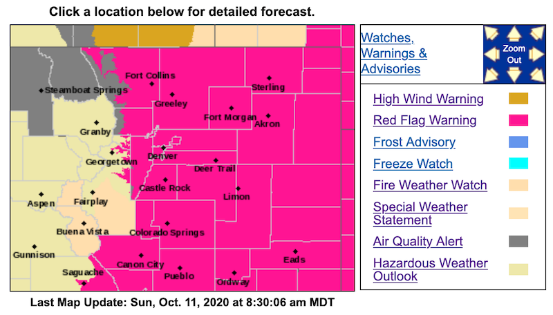
Red Flag Warning
URGENT - FIRE WEATHER MESSAGE
National Weather Service Denver/Boulder CO
345 AM MDT Sun Oct 11 2020
...RED FLAG WARNING FOR STRONGER WINDS OVER THE FOOTHILLS AND PLAINS TODAY...
...FIRE WEATHER WATCH MONDAY AFTERNOON...FOOTHILLS...SOUTH PARK AND ADJACENT PLAINS...
Strong winds are expected over the northern Colorado mountains and foothills today. Very windy conditions will spread across the plains by afternoon behind a pacific cold front. These strong winds will be coincident with low minimum relative humidities, in some areas as low as 10 percent.
COZ238>251-111745-
/O.NEW.KBOU.FW.A.0022.201012T1800Z-201013T0000Z/
/O.CON.KBOU.FW.W.0030.201011T1800Z-201012T0200Z/
Larimer County Below 6000 Feet/Northwest Weld County-
Boulder And Jefferson Counties Below 6000 Feet/West Broomfield County-
North Douglas County Below 6000 Feet/Denver/West Adams and Arapahoe Counties/East Broomfield County-
Elbert/Central and East Douglas Counties Above 6000 Feet-
Northeast Weld County-Central and South Weld County-Morgan County-
Central and East Adams and Arapahoe Counties-
North and Northeast Elbert County Below 6000 Feet/North Lincoln County-
Southeast Elbert County Below 6000 Feet/South Lincoln County-
Logan County-Washington County-Sedgwick County-Phillips County-
345 AM MDT Sun Oct 11 2020
...RED FLAG WARNING REMAINS IN EFFECT FROM NOON TODAY TO 8 PM MDT THIS EVENING FOR WIND AND LOW RELATIVE HUMIDITY FOR THE NORTHEAST COLORADO PLAINS...FIRE ZONES 238 through 251...
...FIRE WEATHER WATCH IN EFFECT MONDAY AFTERNOON FOR WIND AND LOW RELATIVE HUMIDITY FOR THE NORTHEAST COLORADO PLAINS...FIRE ZONES 238 through 251...
The National Weather Service in Denver has issued a Fire Weather Watch FOR WIND AND LOW RELATIVE HUMIDITY, which is in effect Monday afternoon.
* Affected Area...Fire Weather Zones 238, 239, 240, 241, 242, 243, 244, 245, 246, 247, 248, 249, 250 and 251.
* Timing...Noon to 8 PM MDT this evening. On Monday from Noon until 6 pm MDT.
* Winds...West 25 to 35 mph with gusts up to 50 mph. Winds Monday afternoon will gust from 30 to 40 mph.
* Relative Humidity...As low as 10 percent.
PRECAUTIONARY/PREPAREDNESS ACTIONS...
A Red Flag Warning means that critical fire weather conditions are either occurring now....or will shortly. A combination of strong winds...low relative humidity...and warm temperatures can contribute to extreme fire behavior.
A Fire Weather Watch means that critical fire weather conditions are forecast to occur. Listen for later forecasts and possible Red Flag Warnings.
_ _ _ _ _ _ _ _ _ _ _ _ _ _ _ _ _ _ _ _ _ _ _ _ _ _ _ _ _ _ _ _ _ _ _ _ _ _ _ _ _ _ _ _ _ _ _ _ _
URGENT - FIRE WEATHER MESSAGE
National Weather Service Denver/Boulder CO
345 AM MDT Sun Oct 11 2020
...RED FLAG WARNING FOR STRONGER WINDS OVER THE FOOTHILLS AND PLAINS TODAY...
...FIRE WEATHER WATCH MONDAY AFTERNOON...FOOTHILLS...SOUTH PARK AND ADJACENT PLAINS...
COZ215-216-111745-
/O.NEW.KBOU.FW.A.0022.201012T1800Z-201013T0000Z/
/O.CON.KBOU.FW.W.0030.000000T0000Z-201012T0000Z/
Larimer and Boulder Counties Between 6000 and 9000 Feet-
Jefferson and West Douglas Counties Above 6000 Feet/Gilpin/Clear Creek/Northeast Park Counties Below 9000 Feet-
345 AM MDT Sun Oct 11 2020
...RED FLAG WARNING REMAINS IN EFFECT UNTIL 6 PM MDT THIS EVENING FOR WIND AND LOW RELATIVE HUMIDITY FOR THE FOOTHILLS...FIRE WEATHER ZONES 215 AND 216...
...FIRE WEATHER WATCH IN EFFECT MONDAY AFTERNOON FOR WIND AND LOW RELATIVE HUMIDITY FOR THE FOOTHILLS...FIRE WEATHER ZONES 215 AND 216...
The National Weather Service in Denver has issued a Fire Weather Watch FOR WIND AND LOW RELATIVE HUMIDITY, which is in effect Monday afternoon.
* Affected Area...Fire Weather Zones 215 and 216.
* Timing...Strong winds will develop this morning and continue into tonight. Strong winds will continue on Monday.
* Winds...West 20 to 35 mph with gusts up to 60 mph.
* Relative Humidity...As low as 12 percent.
Replied by MountainTownAlerts on topic Red Flag Warning for October 11; High Fire Danger Today & Next Week
Red Flag Warning
URGENT - FIRE WEATHER MESSAGE
National Weather Service Denver/Boulder CO
345 AM MDT Sun Oct 11 2020
...RED FLAG WARNING FOR STRONGER WINDS OVER THE FOOTHILLS AND PLAINS TODAY...
...FIRE WEATHER WATCH MONDAY AFTERNOON...FOOTHILLS...SOUTH PARK AND ADJACENT PLAINS...
Strong winds are expected over the northern Colorado mountains and foothills today. Very windy conditions will spread across the plains by afternoon behind a pacific cold front. These strong winds will be coincident with low minimum relative humidities, in some areas as low as 10 percent.
COZ238>251-111745-
/O.NEW.KBOU.FW.A.0022.201012T1800Z-201013T0000Z/
/O.CON.KBOU.FW.W.0030.201011T1800Z-201012T0200Z/
Larimer County Below 6000 Feet/Northwest Weld County-
Boulder And Jefferson Counties Below 6000 Feet/West Broomfield County-
North Douglas County Below 6000 Feet/Denver/West Adams and Arapahoe Counties/East Broomfield County-
Elbert/Central and East Douglas Counties Above 6000 Feet-
Northeast Weld County-Central and South Weld County-Morgan County-
Central and East Adams and Arapahoe Counties-
North and Northeast Elbert County Below 6000 Feet/North Lincoln County-
Southeast Elbert County Below 6000 Feet/South Lincoln County-
Logan County-Washington County-Sedgwick County-Phillips County-
345 AM MDT Sun Oct 11 2020
...RED FLAG WARNING REMAINS IN EFFECT FROM NOON TODAY TO 8 PM MDT THIS EVENING FOR WIND AND LOW RELATIVE HUMIDITY FOR THE NORTHEAST COLORADO PLAINS...FIRE ZONES 238 through 251...
...FIRE WEATHER WATCH IN EFFECT MONDAY AFTERNOON FOR WIND AND LOW RELATIVE HUMIDITY FOR THE NORTHEAST COLORADO PLAINS...FIRE ZONES 238 through 251...
The National Weather Service in Denver has issued a Fire Weather Watch FOR WIND AND LOW RELATIVE HUMIDITY, which is in effect Monday afternoon.
* Affected Area...Fire Weather Zones 238, 239, 240, 241, 242, 243, 244, 245, 246, 247, 248, 249, 250 and 251.
* Timing...Noon to 8 PM MDT this evening. On Monday from Noon until 6 pm MDT.
* Winds...West 25 to 35 mph with gusts up to 50 mph. Winds Monday afternoon will gust from 30 to 40 mph.
* Relative Humidity...As low as 10 percent.
PRECAUTIONARY/PREPAREDNESS ACTIONS...
A Red Flag Warning means that critical fire weather conditions are either occurring now....or will shortly. A combination of strong winds...low relative humidity...and warm temperatures can contribute to extreme fire behavior.
A Fire Weather Watch means that critical fire weather conditions are forecast to occur. Listen for later forecasts and possible Red Flag Warnings.
_ _ _ _ _ _ _ _ _ _ _ _ _ _ _ _ _ _ _ _ _ _ _ _ _ _ _ _ _ _ _ _ _ _ _ _ _ _ _ _ _ _ _ _ _ _ _ _ _
URGENT - FIRE WEATHER MESSAGE
National Weather Service Denver/Boulder CO
345 AM MDT Sun Oct 11 2020
...RED FLAG WARNING FOR STRONGER WINDS OVER THE FOOTHILLS AND PLAINS TODAY...
...FIRE WEATHER WATCH MONDAY AFTERNOON...FOOTHILLS...SOUTH PARK AND ADJACENT PLAINS...
COZ215-216-111745-
/O.NEW.KBOU.FW.A.0022.201012T1800Z-201013T0000Z/
/O.CON.KBOU.FW.W.0030.000000T0000Z-201012T0000Z/
Larimer and Boulder Counties Between 6000 and 9000 Feet-
Jefferson and West Douglas Counties Above 6000 Feet/Gilpin/Clear Creek/Northeast Park Counties Below 9000 Feet-
345 AM MDT Sun Oct 11 2020
...RED FLAG WARNING REMAINS IN EFFECT UNTIL 6 PM MDT THIS EVENING FOR WIND AND LOW RELATIVE HUMIDITY FOR THE FOOTHILLS...FIRE WEATHER ZONES 215 AND 216...
...FIRE WEATHER WATCH IN EFFECT MONDAY AFTERNOON FOR WIND AND LOW RELATIVE HUMIDITY FOR THE FOOTHILLS...FIRE WEATHER ZONES 215 AND 216...
The National Weather Service in Denver has issued a Fire Weather Watch FOR WIND AND LOW RELATIVE HUMIDITY, which is in effect Monday afternoon.
* Affected Area...Fire Weather Zones 215 and 216.
* Timing...Strong winds will develop this morning and continue into tonight. Strong winds will continue on Monday.
* Winds...West 20 to 35 mph with gusts up to 60 mph.
* Relative Humidity...As low as 12 percent.
Please Log in or Create an account to join the conversation.
- Forum
- Life Up the Hill
- Scanner & Emergency Info, Weather Forecasts
- Red Flag Warning for October 11; High Fire Danger Today & Next Week
Time to create page: 0.180 seconds
sponsors


