- Posts: 9766
- Thank you received: 221
- Forum
- Life Up the Hill
- Scanner & Emergency Info, Weather Forecasts
- Red Flag Warning October 12, 2020; Fire Weather Watch for October 13th
Red Flag Warning October 12, 2020; Fire Weather Watch for October 13th
- MountainTownAlerts
-
 Topic Author
- Mountain Legend
-

Less
More
12 Oct 2020 08:42 #1
by MountainTownAlerts
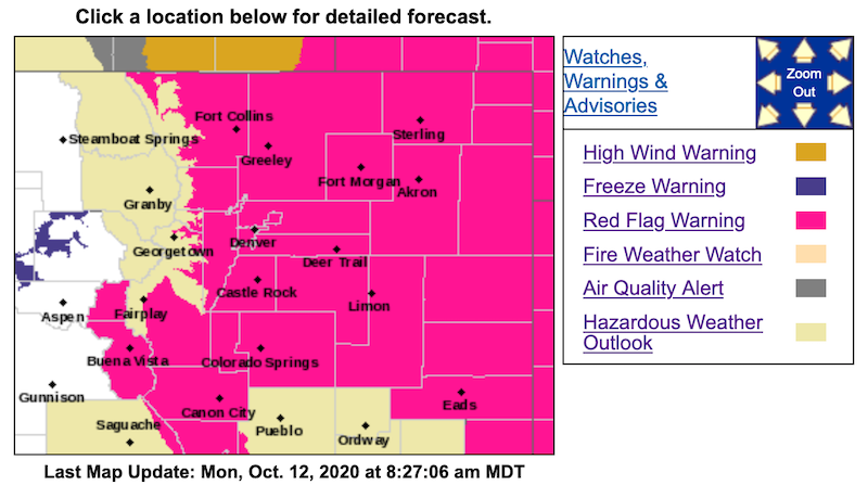
Red Flag Warning
URGENT - FIRE WEATHER MESSAGE
National Weather Service Denver/Boulder CO
340 AM MDT Mon Oct 12 2020
...RED FLAG WARNING FOR THIS AFTERNOON FOR SOUTH PARK...THE FRONT RANGE FOOTHILLS AND ADJACENT PLAINS...
...FIRE WEATHER WATCH FOR SOUTH PARK AND THE NORTHERN FOOTHILLS TUESDAY AFTERNOON...
Drier air will move in today producing low humidities again in the afternoon along with gusty winds leading to critical fire conditions.
COZ214-215-121745-
/O.NEW.KBOU.FW.A.0023.201013T1800Z-201014T0000Z/
/O.CON.KBOU.FW.W.0031.201012T1800Z-201013T0000Z/
Central and Southeast Park County-
Larimer and Boulder Counties Between 6000 and 9000 Feet-
340 AM MDT Mon Oct 12 2020
...RED FLAG WARNING REMAINS IN EFFECT FROM NOON TODAY TO 6 PM MDT THIS EVENING FOR WIND AND LOW RELATIVE HUMIDITY FOR THE FOOTHILLS...FIRE WEATHER ZONES 214 AND 215...
...FIRE WEATHER WATCH IN EFFECT TUESDAY AFTERNOON FOR WIND AND LOW RELATIVE HUMIDITY FOR SOUTH PARK AND NORTHERN FOOTHILLS... FIRE WEATHER ZONES 214 AND 215...
The National Weather Service in Denver has issued a Fire Weather Watch FOR WIND AND LOW RELATIVE HUMIDITY, which is in effect Tuesday afternoon.
* Affected Area...Fire Weather Zones 214 and 215.
* Timing...Drier air will produce lower humidities this afternoon and again Tuesday afternoon. Gusty winds will continue both days.
* Winds...West 20 to 30 mph with gusts from 50 to 60 mph northern Foothills. Over South Park...West winds 15 to 25 mph with gusts to 35 mph.
* Relative Humidity...As low as 12 percent both days.
PRECAUTIONARY/PREPAREDNESS ACTIONS...
A Red Flag Warning means that critical fire weather conditions are either occurring now....or will shortly. A combination of strong winds...low relative humidity...and warm temperatures can contribute to extreme fire behavior.
A Fire Weather Watch means that critical fire weather conditions are forecast to occur. Listen for later forecasts and possiblevRed Flag Warnings.
_ _ _ _ _ _ _ _ _ _ _ _ _ _ _ _ _ _ _ _ _ _ _ _ _ _ _ _ _ _ _ _ _ _ _ _ _ _ _ _ _ _ _ _ _ _ _ _ _
URGENT - FIRE WEATHER MESSAGE
National Weather Service Denver/Boulder CO
340 AM MDT Mon Oct 12 2020
COZ216-121745-
/O.CON.KBOU.FW.W.0031.201012T1800Z-201013T0000Z/
Jefferson and West Douglas Counties Above 6000 Feet/Gilpin/Clear Creek/Northeast Park Counties Below 9000 Feet-
340 AM MDT Mon Oct 12 2020
...RED FLAG WARNING REMAINS IN EFFECT FROM NOON TODAY TO 6 PM MDT THIS EVENING FOR WIND AND LOW RELATIVE HUMIDITY FOR THE SOUTHERN FOOTHILLS...FIRE WEATHER ZONE 216...
* Affected Area...Fire Weather Zone 216.
* Timing...Drier air will produce lower humidities this afternoon. Gusty winds will continue.
* Winds...West 10 to 20 mph with gusts up to 35 mph.
* Relative Humidity...As low as 10 percent.
_ _ _ _ _ _ _ _ _ _ _ _ _ _ _ _ _ _ _ _ _ _ _ _ _ _ _ _ _ _ _ _ _ _ _ _ _ _ _ _ _ _ _ _ _ _ _ _ _
URGENT - FIRE WEATHER MESSAGE
National Weather Service Denver/Boulder CO
340 AM MDT Mon Oct 12 2020
COZ238>251-121745-
/O.CON.KBOU.FW.W.0031.201012T1800Z-201013T0000Z/
Larimer County Below 6000 Feet/Northwest Weld County-
Boulder And Jefferson Counties Below 6000 Feet/West Broomfield County-
North Douglas County Below 6000 Feet/Denver/West Adams and Arapahoe Counties/East Broomfield County-
Elbert/Central and East Douglas Counties Above 6000 Feet-
Northeast Weld County-Central and South Weld County-Morgan County-
Central and East Adams and Arapahoe Counties-
North and Northeast Elbert County Below 6000 Feet/North Lincoln County-
Southeast Elbert County Below 6000 Feet/South Lincoln County-
Logan County-Washington County-Sedgwick County-Phillips County-
340 AM MDT Mon Oct 12 2020
...RED FLAG WARNING REMAINS IN EFFECT FROM NOON TODAY TO 6 PM MDT THIS EVENING FOR WIND AND LOW RELATIVE HUMIDITY FOR THE NORTHEAST COLORADO PLAINS...FIRE ZONES 238 THROUGH 251...
* Affected Area...Fire Weather Zones 238, 239, 240, 241, 242, 243, 244, 245, 246, 247, 248, 249, 250 and 251.
* Timing...Noon until 6 pm MDT this evening.
* Winds...West 15 to 25 mph with gusts up to 40 mph.
* Relative Humidity...As low as 11 percent.
_ _ _ _ _ _ _ _ _ _ _ _ _ _ _ _ _ _ _ _ _ _ _ _ _ _ _ _ _ _ _ _ _ _ _ _ _ _ _ _ _ _ _ _ _ _ _ _ _
URGENT - FIRE WEATHER MESSAGE
National Weather Service Pueblo CO
338 AM MDT Mon Oct 12 2020
...A Red Flag Warning is in effect from noon until 6 PM today for gusty winds, low relative humidity, and dry fuels for fire weather zones 220, 221, 222, 225, 226, 227, 229, 234, 236 and 237 which includes the Sangre de Cristo and Wet Mountains, Lake, Chaffee, El Paso, Fremont, Teller, Huerfano, Kiowa, Prowers and Baca Counties...
...A Fire Weather Watch is in effect for Tuesday afternoon for gusty winds, low relative humidity, and dry fuels for fire weather zones 220, 221, 222, 226 and 227, which includes, Lake, Chaffee, Fremont, Teller and El Paso Counties...
COZ220>222-226-227-130145-
/O.NEW.KPUB.FW.A.0042.201013T1800Z-201014T0000Z/
/O.CON.KPUB.FW.W.0058.201012T1800Z-201013T0000Z/
Upper Arkansas River Valley Including Lake County and Chaffee County-
Teller County/Rampart Range Including Pikes Peak and Florissant Fossil Beds National Monument-
Fremont County Including Canon City/Howard/Texas Creek-
Northern El Paso County Including Monument and Black Forest-
Southern El Paso County Including Fort Carson and Colorado Springs-
338 AM MDT Mon Oct 12 2020
...RED FLAG WARNING REMAINS IN EFFECT FROM NOON TO 6 PM MDT TODAY FOR GUSTY WINDS AND LOW RELATIVE HUMIDITY FOR FIRE WEATHER ZONES 220...221...222...226 AND 227...
...FIRE WEATHER WATCH IN EFFECT TUESDAY AFTERNOON FOR GUSTY WINDS AND LOW RELATIVE HUMIDITY FOR FIRE WEATHER ZONES 220...221...222...226 AND 227...
The National Weather Service in Pueblo has issued a Fire Weather Watch for gusty winds and low relative humidity, which is in effect Tuesday afternoon. A Red Flag Warning remains in effect for today from Noon until 6 PM MDT.
* Affected Area...Fire Weather Zones 220...221...222...226 and 227.
* Winds...West 20 to 30 mph with gusts up to 40 mph today. West to southwest winds on Tuesday at 15 to 25 mph with gusts of 30 to 35 mph.
* Relative Humidity...As low as 8 percent.
* Impacts...Conditions will be favorable for rapid rates of fire growth and spread.
Red Flag Warning October 12, 2020; Fire Weather Watch for October 13th was created by MountainTownAlerts
Red Flag Warning
URGENT - FIRE WEATHER MESSAGE
National Weather Service Denver/Boulder CO
340 AM MDT Mon Oct 12 2020
...RED FLAG WARNING FOR THIS AFTERNOON FOR SOUTH PARK...THE FRONT RANGE FOOTHILLS AND ADJACENT PLAINS...
...FIRE WEATHER WATCH FOR SOUTH PARK AND THE NORTHERN FOOTHILLS TUESDAY AFTERNOON...
Drier air will move in today producing low humidities again in the afternoon along with gusty winds leading to critical fire conditions.
COZ214-215-121745-
/O.NEW.KBOU.FW.A.0023.201013T1800Z-201014T0000Z/
/O.CON.KBOU.FW.W.0031.201012T1800Z-201013T0000Z/
Central and Southeast Park County-
Larimer and Boulder Counties Between 6000 and 9000 Feet-
340 AM MDT Mon Oct 12 2020
...RED FLAG WARNING REMAINS IN EFFECT FROM NOON TODAY TO 6 PM MDT THIS EVENING FOR WIND AND LOW RELATIVE HUMIDITY FOR THE FOOTHILLS...FIRE WEATHER ZONES 214 AND 215...
...FIRE WEATHER WATCH IN EFFECT TUESDAY AFTERNOON FOR WIND AND LOW RELATIVE HUMIDITY FOR SOUTH PARK AND NORTHERN FOOTHILLS... FIRE WEATHER ZONES 214 AND 215...
The National Weather Service in Denver has issued a Fire Weather Watch FOR WIND AND LOW RELATIVE HUMIDITY, which is in effect Tuesday afternoon.
* Affected Area...Fire Weather Zones 214 and 215.
* Timing...Drier air will produce lower humidities this afternoon and again Tuesday afternoon. Gusty winds will continue both days.
* Winds...West 20 to 30 mph with gusts from 50 to 60 mph northern Foothills. Over South Park...West winds 15 to 25 mph with gusts to 35 mph.
* Relative Humidity...As low as 12 percent both days.
PRECAUTIONARY/PREPAREDNESS ACTIONS...
A Red Flag Warning means that critical fire weather conditions are either occurring now....or will shortly. A combination of strong winds...low relative humidity...and warm temperatures can contribute to extreme fire behavior.
A Fire Weather Watch means that critical fire weather conditions are forecast to occur. Listen for later forecasts and possiblevRed Flag Warnings.
_ _ _ _ _ _ _ _ _ _ _ _ _ _ _ _ _ _ _ _ _ _ _ _ _ _ _ _ _ _ _ _ _ _ _ _ _ _ _ _ _ _ _ _ _ _ _ _ _
URGENT - FIRE WEATHER MESSAGE
National Weather Service Denver/Boulder CO
340 AM MDT Mon Oct 12 2020
COZ216-121745-
/O.CON.KBOU.FW.W.0031.201012T1800Z-201013T0000Z/
Jefferson and West Douglas Counties Above 6000 Feet/Gilpin/Clear Creek/Northeast Park Counties Below 9000 Feet-
340 AM MDT Mon Oct 12 2020
...RED FLAG WARNING REMAINS IN EFFECT FROM NOON TODAY TO 6 PM MDT THIS EVENING FOR WIND AND LOW RELATIVE HUMIDITY FOR THE SOUTHERN FOOTHILLS...FIRE WEATHER ZONE 216...
* Affected Area...Fire Weather Zone 216.
* Timing...Drier air will produce lower humidities this afternoon. Gusty winds will continue.
* Winds...West 10 to 20 mph with gusts up to 35 mph.
* Relative Humidity...As low as 10 percent.
_ _ _ _ _ _ _ _ _ _ _ _ _ _ _ _ _ _ _ _ _ _ _ _ _ _ _ _ _ _ _ _ _ _ _ _ _ _ _ _ _ _ _ _ _ _ _ _ _
URGENT - FIRE WEATHER MESSAGE
National Weather Service Denver/Boulder CO
340 AM MDT Mon Oct 12 2020
COZ238>251-121745-
/O.CON.KBOU.FW.W.0031.201012T1800Z-201013T0000Z/
Larimer County Below 6000 Feet/Northwest Weld County-
Boulder And Jefferson Counties Below 6000 Feet/West Broomfield County-
North Douglas County Below 6000 Feet/Denver/West Adams and Arapahoe Counties/East Broomfield County-
Elbert/Central and East Douglas Counties Above 6000 Feet-
Northeast Weld County-Central and South Weld County-Morgan County-
Central and East Adams and Arapahoe Counties-
North and Northeast Elbert County Below 6000 Feet/North Lincoln County-
Southeast Elbert County Below 6000 Feet/South Lincoln County-
Logan County-Washington County-Sedgwick County-Phillips County-
340 AM MDT Mon Oct 12 2020
...RED FLAG WARNING REMAINS IN EFFECT FROM NOON TODAY TO 6 PM MDT THIS EVENING FOR WIND AND LOW RELATIVE HUMIDITY FOR THE NORTHEAST COLORADO PLAINS...FIRE ZONES 238 THROUGH 251...
* Affected Area...Fire Weather Zones 238, 239, 240, 241, 242, 243, 244, 245, 246, 247, 248, 249, 250 and 251.
* Timing...Noon until 6 pm MDT this evening.
* Winds...West 15 to 25 mph with gusts up to 40 mph.
* Relative Humidity...As low as 11 percent.
_ _ _ _ _ _ _ _ _ _ _ _ _ _ _ _ _ _ _ _ _ _ _ _ _ _ _ _ _ _ _ _ _ _ _ _ _ _ _ _ _ _ _ _ _ _ _ _ _
URGENT - FIRE WEATHER MESSAGE
National Weather Service Pueblo CO
338 AM MDT Mon Oct 12 2020
...A Red Flag Warning is in effect from noon until 6 PM today for gusty winds, low relative humidity, and dry fuels for fire weather zones 220, 221, 222, 225, 226, 227, 229, 234, 236 and 237 which includes the Sangre de Cristo and Wet Mountains, Lake, Chaffee, El Paso, Fremont, Teller, Huerfano, Kiowa, Prowers and Baca Counties...
...A Fire Weather Watch is in effect for Tuesday afternoon for gusty winds, low relative humidity, and dry fuels for fire weather zones 220, 221, 222, 226 and 227, which includes, Lake, Chaffee, Fremont, Teller and El Paso Counties...
COZ220>222-226-227-130145-
/O.NEW.KPUB.FW.A.0042.201013T1800Z-201014T0000Z/
/O.CON.KPUB.FW.W.0058.201012T1800Z-201013T0000Z/
Upper Arkansas River Valley Including Lake County and Chaffee County-
Teller County/Rampart Range Including Pikes Peak and Florissant Fossil Beds National Monument-
Fremont County Including Canon City/Howard/Texas Creek-
Northern El Paso County Including Monument and Black Forest-
Southern El Paso County Including Fort Carson and Colorado Springs-
338 AM MDT Mon Oct 12 2020
...RED FLAG WARNING REMAINS IN EFFECT FROM NOON TO 6 PM MDT TODAY FOR GUSTY WINDS AND LOW RELATIVE HUMIDITY FOR FIRE WEATHER ZONES 220...221...222...226 AND 227...
...FIRE WEATHER WATCH IN EFFECT TUESDAY AFTERNOON FOR GUSTY WINDS AND LOW RELATIVE HUMIDITY FOR FIRE WEATHER ZONES 220...221...222...226 AND 227...
The National Weather Service in Pueblo has issued a Fire Weather Watch for gusty winds and low relative humidity, which is in effect Tuesday afternoon. A Red Flag Warning remains in effect for today from Noon until 6 PM MDT.
* Affected Area...Fire Weather Zones 220...221...222...226 and 227.
* Winds...West 20 to 30 mph with gusts up to 40 mph today. West to southwest winds on Tuesday at 15 to 25 mph with gusts of 30 to 35 mph.
* Relative Humidity...As low as 8 percent.
* Impacts...Conditions will be favorable for rapid rates of fire growth and spread.
Please Log in or Create an account to join the conversation.
- Forum
- Life Up the Hill
- Scanner & Emergency Info, Weather Forecasts
- Red Flag Warning October 12, 2020; Fire Weather Watch for October 13th
Time to create page: 0.166 seconds
sponsors


