- Posts: 9766
- Thank you received: 221
- Forum
- Life Up the Hill
- Scanner & Emergency Info, Weather Forecasts
- Red Flag Warning October 21-22, 2020
Red Flag Warning October 21-22, 2020
- MountainTownAlerts
-
 Topic Author
- Mountain Legend
-

Less
More
21 Oct 2020 05:16 #1
by MountainTownAlerts
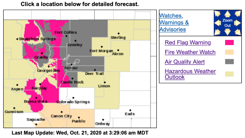
URGENT - FIRE WEATHER MESSAGE
National Weather Service Denver/Boulder CO
138 AM MDT Wed Oct 21 2020
...RED FLAG WARNING FOR THE MOUNTAIN VALLEYS THIS AFTERNOON AND EVENING FOR LOW HUMIDITY AND GUSTY WINDS...
...RED FLAG WARNING FOR THE FRONT RANGE FOOTHILLS THIS AFTERNOON AND TONIGHT FOR LOW HUMIDITY...GUSTY WINDS...AND POOR RECOVERY OVERNIGHT...
.Winds will increase today ahead of a weather system that will pass over Colorado on Thursday. It will also be a little warmer and drier. As a result, Red Flag conditions are expected in the mountain valleys and foothills this afternoon. Conditions will improve in the valleys this evening, but the foothills will have windy conditions continuing with poor humidity recovery. Overnight maximum humidity in the foothills will be in the 20 to 30 percent range while winds increase with gusts of up to 50 mph possible, mainly in the higher foothills and wind prone lower foothill locations. The foothills will see a shift to northeast winds with cooler temperatures and higher humidities behind a cold front Thursday morning. These winds may also gust up to 30 mph during the day Thursday.
COZ216-211800-
/O.EXA.KBOU.FW.W.0037.201021T1800Z-201022T1400Z/
Jefferson and West Douglas Counties Above 6000 Feet/Gilpin/Clear Creek/Northeast Park Counties Below 9000 Feet-
138 AM MDT Wed Oct 21 2020
...RED FLAG WARNING IN EFFECT FROM NOON TODAY TO 8 AM MDT THURSDAY FOR WIND AND LOW RELATIVE HUMIDITY FOR THE SOUTHERN FRONT RANGE FOOTHILLS...
The National Weather Service in Denver has issued a Red Flag Warning for wind and low relative humidity, which is in effect from noon today to 8 AM MDT Thursday.
* Affected Area...Fire Weather Zone 216.
* Timing...From noon Wednesday to 8 AM MDT Thursday.
* Winds...Southwest 10 to 20 mph with gusts up to 40 mph.
* Relative Humidity...As low as 12 percent. Poor humidity recovery overnight.
* Impacts...Fires will start easily and spread rapidly.
PRECAUTIONARY/PREPAREDNESS ACTIONS...
A Red Flag Warning means that critical fire weather conditions are either occurring now....or will shortly. A combination of strong winds...low relative humidity...and warm temperatures can contribute to extreme fire behavior.
_ _ _ _ _ _ _ _ _ _ _ _ _ _ _ _ _ _ _ _ _ _ _ _ _ _ _ _ _ _ _ _ _ _ _ _ _ _ _ _ _ _ _ _ _ _ _ _
URGENT - FIRE WEATHER MESSAGE
National Weather Service Denver/Boulder CO
138 AM MDT Wed Oct 21 2020
...RED FLAG WARNING FOR THE MOUNTAIN VALLEYS THIS AFTERNOON AND EVENING FOR LOW HUMIDITY AND GUSTY WINDS...
...RED FLAG WARNING FOR THE FRONT RANGE FOOTHILLS THIS AFTERNOON AND TONIGHT FOR LOW HUMIDITY...GUSTY WINDS...AND POOR RECOVERY OVERNIGHT...
COZ213-214-211800-
/O.CON.KBOU.FW.W.0037.201021T1800Z-201022T0100Z/
Grand and Summit Counties Below 9000 Feet-
Central and Southeast Park County-
138 AM MDT Wed Oct 21 2020
...RED FLAG WARNING REMAINS IN EFFECT FROM NOON TODAY TO 7 PM MDT THIS EVENING FOR WIND AND LOW RELATIVE HUMIDITY FOR MIDDLE PARK AND SOUTH PARK...
* Affected Area...Fire Weather Zones 213 and 214.
* Timing...Noon to 7 PM MDT, Wednesday.
* Winds...West 15 to 25 mph with gusts up to 40 mph.
* Relative Humidity...As low as 12 percent.
* Impacts...Fires will start easily and spread rapidly.
Red Flag Warning October 21-22, 2020 was created by MountainTownAlerts
URGENT - FIRE WEATHER MESSAGE
National Weather Service Denver/Boulder CO
138 AM MDT Wed Oct 21 2020
...RED FLAG WARNING FOR THE MOUNTAIN VALLEYS THIS AFTERNOON AND EVENING FOR LOW HUMIDITY AND GUSTY WINDS...
...RED FLAG WARNING FOR THE FRONT RANGE FOOTHILLS THIS AFTERNOON AND TONIGHT FOR LOW HUMIDITY...GUSTY WINDS...AND POOR RECOVERY OVERNIGHT...
.Winds will increase today ahead of a weather system that will pass over Colorado on Thursday. It will also be a little warmer and drier. As a result, Red Flag conditions are expected in the mountain valleys and foothills this afternoon. Conditions will improve in the valleys this evening, but the foothills will have windy conditions continuing with poor humidity recovery. Overnight maximum humidity in the foothills will be in the 20 to 30 percent range while winds increase with gusts of up to 50 mph possible, mainly in the higher foothills and wind prone lower foothill locations. The foothills will see a shift to northeast winds with cooler temperatures and higher humidities behind a cold front Thursday morning. These winds may also gust up to 30 mph during the day Thursday.
COZ216-211800-
/O.EXA.KBOU.FW.W.0037.201021T1800Z-201022T1400Z/
Jefferson and West Douglas Counties Above 6000 Feet/Gilpin/Clear Creek/Northeast Park Counties Below 9000 Feet-
138 AM MDT Wed Oct 21 2020
...RED FLAG WARNING IN EFFECT FROM NOON TODAY TO 8 AM MDT THURSDAY FOR WIND AND LOW RELATIVE HUMIDITY FOR THE SOUTHERN FRONT RANGE FOOTHILLS...
The National Weather Service in Denver has issued a Red Flag Warning for wind and low relative humidity, which is in effect from noon today to 8 AM MDT Thursday.
* Affected Area...Fire Weather Zone 216.
* Timing...From noon Wednesday to 8 AM MDT Thursday.
* Winds...Southwest 10 to 20 mph with gusts up to 40 mph.
* Relative Humidity...As low as 12 percent. Poor humidity recovery overnight.
* Impacts...Fires will start easily and spread rapidly.
PRECAUTIONARY/PREPAREDNESS ACTIONS...
A Red Flag Warning means that critical fire weather conditions are either occurring now....or will shortly. A combination of strong winds...low relative humidity...and warm temperatures can contribute to extreme fire behavior.
_ _ _ _ _ _ _ _ _ _ _ _ _ _ _ _ _ _ _ _ _ _ _ _ _ _ _ _ _ _ _ _ _ _ _ _ _ _ _ _ _ _ _ _ _ _ _ _
URGENT - FIRE WEATHER MESSAGE
National Weather Service Denver/Boulder CO
138 AM MDT Wed Oct 21 2020
...RED FLAG WARNING FOR THE MOUNTAIN VALLEYS THIS AFTERNOON AND EVENING FOR LOW HUMIDITY AND GUSTY WINDS...
...RED FLAG WARNING FOR THE FRONT RANGE FOOTHILLS THIS AFTERNOON AND TONIGHT FOR LOW HUMIDITY...GUSTY WINDS...AND POOR RECOVERY OVERNIGHT...
COZ213-214-211800-
/O.CON.KBOU.FW.W.0037.201021T1800Z-201022T0100Z/
Grand and Summit Counties Below 9000 Feet-
Central and Southeast Park County-
138 AM MDT Wed Oct 21 2020
...RED FLAG WARNING REMAINS IN EFFECT FROM NOON TODAY TO 7 PM MDT THIS EVENING FOR WIND AND LOW RELATIVE HUMIDITY FOR MIDDLE PARK AND SOUTH PARK...
* Affected Area...Fire Weather Zones 213 and 214.
* Timing...Noon to 7 PM MDT, Wednesday.
* Winds...West 15 to 25 mph with gusts up to 40 mph.
* Relative Humidity...As low as 12 percent.
* Impacts...Fires will start easily and spread rapidly.
Please Log in or Create an account to join the conversation.
- MountainTownAlerts
-
Topic Author
- Mountain Legend
-
Less
More
- Posts: 9766
- Thank you received: 221
22 Oct 2020 08:57 #2
by MountainTownAlerts
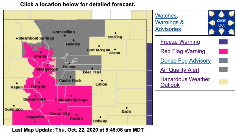
Red Flag Warning
URGENT - FIRE WEATHER MESSAGE
National Weather Service Denver/Boulder CO
749 AM MDT Thu Oct 22 2020
...RED FLAG WARNING FROM 10 AM THIS MORNING TO 7 PM MDT THIS EVENING FOR WIND AND LOW RELATIVE HUMIDITY FOR MIDDLE PARK, SOUTH PARK, AND THE HIGH MOUNTAINS OF BOULDER, GILPIN, CLEAR CREEK, SUMMIT AND PARK COUNTIES...FIRE WEATHER ZONES 212, 213 AND 214...
.Very low dewpoints and strong west-southwest winds over the high mountains and valleys will lead to critical fire weather conditions today as humidities will be in the low to mid teens and winds gusting 25 to upwards of 50 mph at elevations above 10,000 feet. A weather system moving down from the north, which brought a cold front to the plains and lower Front Range foothills, isn`t expected to bring the higher dewpoints to the higher elevations until later this afternoon. Elevations above this cold front on the lee slopes of the Front Range Mountains will be in much drier air, with westerly winds gusting 25 to 40 mph. Conditions over the far northern mountains, including North Park, Rocky Mountain National Park and the upper foothills of Larimer County will be near critical this morning, but improving by noon as the weather system pushes down from the north.
COZ214-222200-
/O.CON.KBOU.FW.W.0038.201022T1600Z-201023T0100Z/
Central and Southeast Park County-
749 AM MDT Thu Oct 22 2020
...RED FLAG WARNING REMAINS IN EFFECT UNTIL 7 PM MDT THIS EVENING FOR WIND AND LOW RELATIVE HUMIDITY FOR SOUTH PARK...
* Affected Area...Fire Weather Zone 214.
* Timing...10 AM MDT this morning until 7 PM this evening.
* Winds...West 10 to 20 mph with gusts up to 40 mph.
* Relative Humidity...As low as 14 percent.
* Impacts...Ongoing drought conditions combined with strong winds and low relative humidity mean conditions are prime for rapid fire growth.
PRECAUTIONARY/PREPAREDNESS ACTIONS...
A Red Flag Warning means that critical fire weather conditions are either occurring now....or will shortly. A combination of strong winds...low relative humidity...and warm temperatures can contribute to extreme fire behavior.
_ _ _ _ _ _ _ _ _ _ _ _ _ _ _ _ _ _ _ _ _ _ _ _ _ _ _ _ _ _ _ _ _ _ _ _ _ _ _ _ _ _
URGENT - FIRE WEATHER MESSAGE
National Weather Service Denver/Boulder CO
749 AM MDT Thu Oct 22 2020
...RED FLAG WARNING FROM 10 AM THIS MORNING TO 7 PM MDT THIS EVENING FOR WIND AND LOW RELATIVE HUMIDITY FOR MIDDLE PARK, SOUTH PARK, AND THE HIGH MOUNTAINS OF BOULDER, GILPIN, CLEAR CREEK, SUMMIT AND PARK COUNTIES...FIRE WEATHER ZONES 212, 213 AND 214...
COZ212-213-222200-
/O.EXA.KBOU.FW.W.0038.201022T1600Z-201023T0100Z/
South and Southeast Grand/West Central and Southwest Boulder/Gilpin/Clear Creek/Summit/North and West Park Counties Above 9000 Feet-\
Grand and Summit Counties Below 9000 Feet-
749 AM MDT Thu Oct 22 2020
...RED FLAG WARNING IN EFFECT UNTIL 7 PM MDT THIS EVENING FOR WIND AND LOW RELATIVE HUMIDITY FOR MIDDLE PARK AND THE HIGHER MOUNTAINS TO THE EAST AND SOUTH, INCLUDING MOUNTAINS ABOVE 9000 FEET IN BOULDER, GILPIN, CLEAR CREEK, GRAND AND PARK COUNTIES...
The National Weather Service in Denver has issued a Red Flag Warning for wind and low relative humidity, which is in effect until 7 PM MDT this evening.
* Affected Area...Fire Weather Zones 212 and 213.
* Timing...10 AM MDT this morning until 7 PM this evening, with higher humidities starting to spread from the north and east after 5 PM.
* Winds...West 15 to 25 mph with gusts up to 50 mph.
* Relative Humidity...As low as 15 percent.
* Impacts...Ongoing drought conditions combined with strong winds and low relative humidity mean conditions are prime for rapid fire growth.
PRECAUTIONARY/PREPAREDNESS ACTIONS...
A Red Flag Warning means that critical fire weather conditions are either occurring now....or will shortly. A combination of strong winds...low relative humidity...and warm temperatures can contribute to extreme fire behavior.
Replied by MountainTownAlerts on topic Red Flag Warning October 21-22, 2020
Red Flag Warning
URGENT - FIRE WEATHER MESSAGE
National Weather Service Denver/Boulder CO
749 AM MDT Thu Oct 22 2020
...RED FLAG WARNING FROM 10 AM THIS MORNING TO 7 PM MDT THIS EVENING FOR WIND AND LOW RELATIVE HUMIDITY FOR MIDDLE PARK, SOUTH PARK, AND THE HIGH MOUNTAINS OF BOULDER, GILPIN, CLEAR CREEK, SUMMIT AND PARK COUNTIES...FIRE WEATHER ZONES 212, 213 AND 214...
.Very low dewpoints and strong west-southwest winds over the high mountains and valleys will lead to critical fire weather conditions today as humidities will be in the low to mid teens and winds gusting 25 to upwards of 50 mph at elevations above 10,000 feet. A weather system moving down from the north, which brought a cold front to the plains and lower Front Range foothills, isn`t expected to bring the higher dewpoints to the higher elevations until later this afternoon. Elevations above this cold front on the lee slopes of the Front Range Mountains will be in much drier air, with westerly winds gusting 25 to 40 mph. Conditions over the far northern mountains, including North Park, Rocky Mountain National Park and the upper foothills of Larimer County will be near critical this morning, but improving by noon as the weather system pushes down from the north.
COZ214-222200-
/O.CON.KBOU.FW.W.0038.201022T1600Z-201023T0100Z/
Central and Southeast Park County-
749 AM MDT Thu Oct 22 2020
...RED FLAG WARNING REMAINS IN EFFECT UNTIL 7 PM MDT THIS EVENING FOR WIND AND LOW RELATIVE HUMIDITY FOR SOUTH PARK...
* Affected Area...Fire Weather Zone 214.
* Timing...10 AM MDT this morning until 7 PM this evening.
* Winds...West 10 to 20 mph with gusts up to 40 mph.
* Relative Humidity...As low as 14 percent.
* Impacts...Ongoing drought conditions combined with strong winds and low relative humidity mean conditions are prime for rapid fire growth.
PRECAUTIONARY/PREPAREDNESS ACTIONS...
A Red Flag Warning means that critical fire weather conditions are either occurring now....or will shortly. A combination of strong winds...low relative humidity...and warm temperatures can contribute to extreme fire behavior.
_ _ _ _ _ _ _ _ _ _ _ _ _ _ _ _ _ _ _ _ _ _ _ _ _ _ _ _ _ _ _ _ _ _ _ _ _ _ _ _ _ _
URGENT - FIRE WEATHER MESSAGE
National Weather Service Denver/Boulder CO
749 AM MDT Thu Oct 22 2020
...RED FLAG WARNING FROM 10 AM THIS MORNING TO 7 PM MDT THIS EVENING FOR WIND AND LOW RELATIVE HUMIDITY FOR MIDDLE PARK, SOUTH PARK, AND THE HIGH MOUNTAINS OF BOULDER, GILPIN, CLEAR CREEK, SUMMIT AND PARK COUNTIES...FIRE WEATHER ZONES 212, 213 AND 214...
COZ212-213-222200-
/O.EXA.KBOU.FW.W.0038.201022T1600Z-201023T0100Z/
South and Southeast Grand/West Central and Southwest Boulder/Gilpin/Clear Creek/Summit/North and West Park Counties Above 9000 Feet-\
Grand and Summit Counties Below 9000 Feet-
749 AM MDT Thu Oct 22 2020
...RED FLAG WARNING IN EFFECT UNTIL 7 PM MDT THIS EVENING FOR WIND AND LOW RELATIVE HUMIDITY FOR MIDDLE PARK AND THE HIGHER MOUNTAINS TO THE EAST AND SOUTH, INCLUDING MOUNTAINS ABOVE 9000 FEET IN BOULDER, GILPIN, CLEAR CREEK, GRAND AND PARK COUNTIES...
The National Weather Service in Denver has issued a Red Flag Warning for wind and low relative humidity, which is in effect until 7 PM MDT this evening.
* Affected Area...Fire Weather Zones 212 and 213.
* Timing...10 AM MDT this morning until 7 PM this evening, with higher humidities starting to spread from the north and east after 5 PM.
* Winds...West 15 to 25 mph with gusts up to 50 mph.
* Relative Humidity...As low as 15 percent.
* Impacts...Ongoing drought conditions combined with strong winds and low relative humidity mean conditions are prime for rapid fire growth.
PRECAUTIONARY/PREPAREDNESS ACTIONS...
A Red Flag Warning means that critical fire weather conditions are either occurring now....or will shortly. A combination of strong winds...low relative humidity...and warm temperatures can contribute to extreme fire behavior.
Please Log in or Create an account to join the conversation.
- Forum
- Life Up the Hill
- Scanner & Emergency Info, Weather Forecasts
- Red Flag Warning October 21-22, 2020
Time to create page: 0.168 seconds
sponsors


