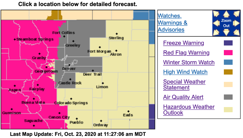
Red Flag Warning
URGENT - FIRE WEATHER MESSAGE
National Weather Service Denver/Boulder CO
337 AM MDT Fri Oct 23 2020
...RED FLAG WARNING IN EFFECT FROM NOON TODAY TO 7 PM MDT SATURDAY FOR WIND AND LOW RELATIVE HUMIDITY FOR THE MOUNTAINS AND MOUNTAINS VALLEYS, FIRE WEATHER ZONES, 211, 212, 213, 214, 217, AND 218...
...RED FLAG WARNING IN EFFECT FROM MIDNIGHT TONIGHT TO 7 PM MDT SATURDAY FOR WIND AND LOW RELATIVE HUMIDITY FOR THE NORTHERN FOOTHILLS, FIRE WEATHER ZONE 215...
Winds will begin to increase again this afternoon and especially tonight and Saturday. Wind gusts will likely increase to around 40 mph in the valleys by Saturday, with gusts up to 60 mph or more over the mountains and northern foothills. Relative humidities will plummet into the teens today across the mountains and valleys. Relative humidity slowly increases overnight, but recoveries will be poor. The existing fires burning in heavy fuels may lead to considerable additional growth today through Saturday.
COZ211>214-217-218-232200-
/O.UPG.KBOU.FW.A.0024.201023T1800Z-201025T0100Z/
/O.NEW.KBOU.FW.W.0039.201023T1800Z-201025T0100Z/
Jackson County Below 9000 Feet-
South and Southeast Grand/West Central and Southwest Boulder/Gilpin/
Clear Creek/Summit/North and West Park Counties Above 9000 Feet-
Grand and
Summit Counties Below 9000 Feet-
Central and Southeast Park County-
West Jackson and West Grand Counties Above 9000 Feet-
South and East Jackson/Larimer/North and Northeast Grand/Northwest Boulder Counties Above 9000 Feet-
337 AM MDT Fri Oct 23 2020
...
RED FLAG WARNING IN EFFECT FROM NOON TODAY TO 7 PM MDT SATURDAY FOR WIND AND LOW RELATIVE HUMIDITY FOR THE MOUNTAINS AND MOUNTAINS VALLEYS, FIRE WEATHER ZONES, 211, 212, 213, 214, 217, AND 218...
The National Weather Service in Denver has issued a Red Flag Warning for wind and low relative humidity, which is in effect from noon today to 7 PM MDT Saturday. The Fire Weather Watch is no longer in effect.
* Affected Area...Fire Weather Zones 211, 212, 213, 214, 217, and 218.
* Timing...Winds will increase Friday afternoon and become stronger Friday night and Saturday.
* Winds...West 20 to 30 mph with gusts up to 60 mph.
* Relative Humidity...As low as 12 percent.
* Impacts...Ongoing drought conditions combined with strong winds and low relative humidity mean conditions are prime for rapid fire growth.
PRECAUTIONARY/PREPAREDNESS ACTIONS...
A Red Flag Warning means that critical fire weather conditions are either occurring now....or will shortly. A combination of strong winds...low relative humidity...and warm temperatures can contribute to extreme fire behavior.