- Posts: 9766
- Thank you received: 221
- Forum
- Life Up the Hill
- Scanner & Emergency Info, Weather Forecasts
- Winter Storm Warning October 25-26, 2020
Winter Storm Warning October 25-26, 2020
- MountainTownAlerts
-
 Topic Author
- Mountain Legend
-

Less
More
23 Oct 2020 20:22 #1
by MountainTownAlerts
Winter Storm Warning October 25-26, 2020 was created by MountainTownAlerts
From Chief Meteorlogist Steve Hamilton:
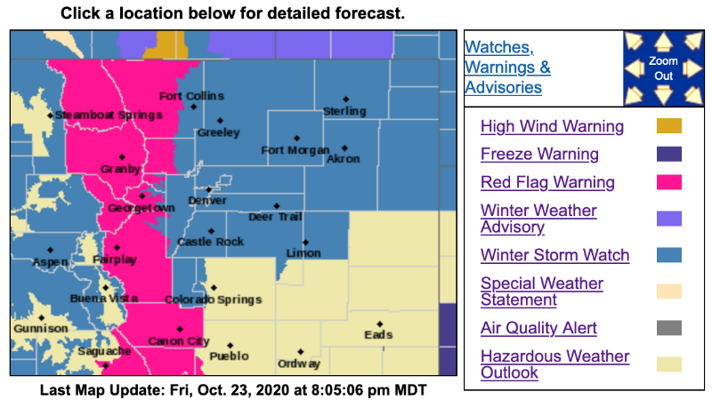
Winter Storm Watch: Late Saturday Through Early Monday...
The National Weather Service in Boulder has issued a Winter Storm Watch, including all of the foothills, and adjacent Denver metro and northeast plains. This goes from late Saturday night through Monday morning.
Possible accumulations:
6 to 12" in the foothills
8 to 14" in the higher mountains
4 to 6" in the Denver area and eastern plains.
We will also have frigid temperatures, with Sunday's highs only in the lower 20s. Gusty wind and poor visibility are likely.
NWS may upgrade the Watch to a Warning, and we will keep you advised.
URGENT - WINTER WEATHER MESSAGE
National Weather Service Denver/Boulder CO
246 PM MDT Fri Oct 23 2020
...WINTER SNOW AND COLD HEADED FOR COLORADO...
.A storm system will drop southward across colorado starting Saturday night, with much colder temperatures and accumulating snowfall. Snow will first develop over the northern border area late Saturday evening, and then spread slowly southward into the I-70 late Saturday night or Sunday morning. The heaviest snow is expected to fall on Sunday, before tapering off Sunday night into Monday morning.
Temperatures will be very cold, with highs only in the lower to mid 20s on Sunday, and then single digit lows Sunday night.
The colder temperatures and snow will result in snow covered roads, and slick travel conditions. If you are planning to travel, be prepared for slower than normal travel conditions, and use extra time to reach your destination safely. Also, be prepared for the sharp change in temperatures and dress warmly in several layers of clothing.
COZ034-036>039-240500-
/O.NEW.KBOU.WS.A.0009.201025T1200Z-201026T1200Z/
South and Southeast Grand/West Central and Southwest Boulder/Gilpin/Clear Creek/Summit/North and West Park Counties Above 9000 Feet-
Jefferson and West Douglas Counties Above 6000 Feet/Gilpin/Clear Creek/Northeast Park Counties Below 9000 Feet-
Central and Southeast Park County-
Larimer County Below 6000 Feet/Northwest Weld County-
Boulder And Jefferson Counties Below 6000 Feet/West Broomfield County-
Including Berthoud Pass, Breckenridge, East Slopes Mosquito Range, East Slopes Southern Gore Range, Eisenhower Tunnel, Indian Peaks, Kenosha Mountains, Mount Evans, Williams Fork Mountains, Winter Park, Bailey, Central City, Evergreen, Georgetown, Idaho Springs, Westcreek, Fairplay, Hartsel, Lake George, South Park, Fort Collins, Hereford, Loveland, Nunn, Arvada, Boulder, Golden, Lakewood, and Longmont
246 PM MDT Fri Oct 23 2020
...WINTER STORM WATCH IN EFFECT FROM SUNDAY MORNING THROUGH LATE SUNDAY NIGHT...
* WHAT...Heavy snow possible. Total snow accumulations of 6 to 12 inches possible in the mountains and foothills, with 5 to 10 inches possible in the Boulder to Fort Collins Corridor.
* WHERE...The Mountains of Summit County, the Mosquito Range, and the Indian Peaks, The Southern Front Range Foothills, South Park, Larimer County below 6000 feet and Northwest Weld County and Boulder and the western suburbs of Denver.
* WHEN...From Sunday morning through late Sunday night.
* IMPACTS...Travel could be difficult. Allow extra time to reach your destination safely.
PRECAUTIONARY/PREPAREDNESS ACTIONS...
Monitor the latest forecasts for updates on this situation.
Please Log in or Create an account to join the conversation.
- MountainTownAlerts
-
Topic Author
- Mountain Legend
-
Less
More
- Posts: 9766
- Thank you received: 221
24 Oct 2020 15:00 #2
by MountainTownAlerts
Replied by MountainTownAlerts on topic Winter Storm Warning October 25-26, 2020
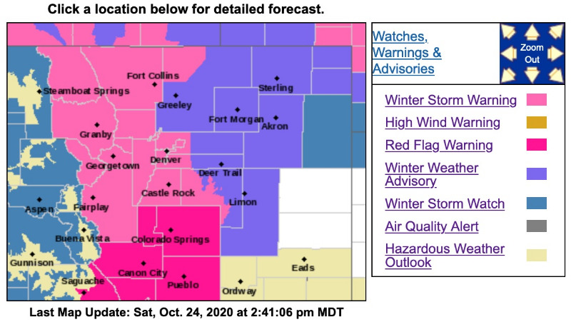
The Winter Storm Watch has been upgraded to a Winter Storm Warning for Jeffco, Park, and Clear Creek Counties.
URGENT - WINTER WEATHER MESSAGE
National Weather Service Denver/Boulder CO
241 PM MDT Sat Oct 24 2020
...WINTER SNOW AND COLD HEADED FOR COLORADO...
.A storm system will drop southward across Colorado starting later tonight, with much colder temperatures and accumulating snowfall. Snow will first develop over the northern border area this evening, and then spread slowly southward late tonight into Sunday morning. The heaviest snow is expected to fall on Sunday, before tapering off late Sunday night into Monday morning.
Temperatures will be very cold, with highs only in the teens to lower 20s on Sunday. Lows Sunday night will be below zero over the higher terrain with single digits over the plains.
The colder temperatures and snow will result in snow covered roads, and slick travel conditions. If you are planning to travel, be prepared for slower than normal travel conditions, and use extra time to reach your destination safely. Also, be prepared for the sharp change in temperatures and dress warmly in several layers of clothing.
COZ034-036-037-250445-
/O.UPG.KBOU.WS.A.0009.201025T1200Z-201026T1200Z/
/O.NEW.KBOU.WS.W.0007.201025T1200Z-201026T1200Z/
South and Southeast Grand/West Central and Southwest Boulder/Gilpin/Clear Creek/Summit/North and West Park Counties Above 9000 Feet-
Jefferson and West Douglas Counties Above 6000 Feet/Gilpin/Clear Creek/Northeast Park Counties Below 9000 Feet-
Central and Southeast Park County-
Including Berthoud Pass, Breckenridge, East Slopes Mosquito Range, East Slopes Southern Gore Range, Eisenhower Tunnel, Indian Peaks, Kenosha Mountains, Mount Evans, Williams Fork Mountains, Winter Park, Bailey, Central City, Evergreen, Georgetown, Idaho Springs, Westcreek, Fairplay, Hartsel, Lake George, and South Park
241 PM MDT Sat Oct 24 2020
...WINTER STORM WARNING IN EFFECT FROM 6 AM SUNDAY TO 6 AM MDT MONDAY...
* WHAT...Heavy snow expected. Total snow accumulations of 8 to 14 inches. Winds gusting as high as 30 mph.
* WHERE...The Mountains of Summit County, the Mosquito Range, and the Indian Peaks, The Southern Front Range Foothills and South Park.
* WHEN...From 6 AM Sunday to 6 AM MDT Monday.
* IMPACTS...Travel could be difficult with a slow morning commute Monday morning. The cold wind chills as low as 25 below zero could cause frostbite on exposed skin in as little as 30 minutes.
PRECAUTIONARY/PREPAREDNESS ACTIONS...
If you must travel, keep an extra flashlight, food, and water in your vehicle in case of an emergency.
The latest road conditions for the state you are calling from can be obtained by calling 5 1 1.
_ _ _ _ _ _ _ _ _ _ _ _ _ _ _ _ _ _ _ _ _ _ _ _ _ _ _ _ _ _ _ _ _ _ _ _ _ _ _ _ _ _ _ _ _
URGENT - WINTER WEATHER MESSAGE
National Weather Service Denver/Boulder CO
241 PM MDT Sat Oct 24 2020
...WINTER SNOW AND COLD HEADED FOR COLORADO...
COZ038>041-250445-
/O.UPG.KBOU.WS.A.0009.201025T1200Z-201026T1200Z/
/O.NEW.KBOU.WS.W.0007.201025T1200Z-201026T1200Z/
Larimer County Below 6000 Feet/Northwest Weld County-
Boulder And Jefferson Counties Below 6000 Feet/West Broomfield County-
North Douglas County Below 6000 Feet/Denver/West Adams and Arapahoe Counties/East Broomfield County-
Elbert/Central and East Douglas Counties Above 6000 Feet-
Including Fort Collins, Hereford, Loveland, Nunn, Arvada, Boulder, Golden, Lakewood, Longmont, Aurora, Brighton, City of Denver, Denver International Airport, Highlands Ranch, Littleton, Parker, Castle Rock, Elbert, Fondis, Kiowa, and Larkspur
241 PM MDT Sat Oct 24 2020
...WINTER STORM WARNING IN EFFECT FROM 6 AM SUNDAY TO 6 AM MDT MONDAY...
* WHAT...Heavy snow expected. Total snow accumulations of 5 to 10 inches. Highest amounts near the foothills.
* WHERE...Larimer County below 6000 feet and Northwest Weld County, Boulder and the western suburbs of Denver, Denver and Palmer Divide including Castle Rock, Elbert, and Larkspur.
* WHEN...From 6 AM Sunday to 6 AM MDT Monday.
* IMPACTS...Travel could be difficult with a slow morning commute Monday morning.
PRECAUTIONARY/PREPAREDNESS ACTIONS...
If you must travel, keep an extra flashlight, food, and water in your vehicle in case of an emergency.
The latest road conditions for the state you are calling from can be obtained by calling 5 1 1.
URGENT - WINTER WEATHER MESSAGE
National Weather Service Denver/Boulder CO
241 PM MDT Sat Oct 24 2020
...WINTER SNOW AND COLD HEADED FOR COLORADO...
.A storm system will drop southward across Colorado starting later tonight, with much colder temperatures and accumulating snowfall. Snow will first develop over the northern border area this evening, and then spread slowly southward late tonight into Sunday morning. The heaviest snow is expected to fall on Sunday, before tapering off late Sunday night into Monday morning.
Temperatures will be very cold, with highs only in the teens to lower 20s on Sunday. Lows Sunday night will be below zero over the higher terrain with single digits over the plains.
The colder temperatures and snow will result in snow covered roads, and slick travel conditions. If you are planning to travel, be prepared for slower than normal travel conditions, and use extra time to reach your destination safely. Also, be prepared for the sharp change in temperatures and dress warmly in several layers of clothing.
COZ034-036-037-250445-
/O.UPG.KBOU.WS.A.0009.201025T1200Z-201026T1200Z/
/O.NEW.KBOU.WS.W.0007.201025T1200Z-201026T1200Z/
South and Southeast Grand/West Central and Southwest Boulder/Gilpin/Clear Creek/Summit/North and West Park Counties Above 9000 Feet-
Jefferson and West Douglas Counties Above 6000 Feet/Gilpin/Clear Creek/Northeast Park Counties Below 9000 Feet-
Central and Southeast Park County-
Including Berthoud Pass, Breckenridge, East Slopes Mosquito Range, East Slopes Southern Gore Range, Eisenhower Tunnel, Indian Peaks, Kenosha Mountains, Mount Evans, Williams Fork Mountains, Winter Park, Bailey, Central City, Evergreen, Georgetown, Idaho Springs, Westcreek, Fairplay, Hartsel, Lake George, and South Park
241 PM MDT Sat Oct 24 2020
...WINTER STORM WARNING IN EFFECT FROM 6 AM SUNDAY TO 6 AM MDT MONDAY...
* WHAT...Heavy snow expected. Total snow accumulations of 8 to 14 inches. Winds gusting as high as 30 mph.
* WHERE...The Mountains of Summit County, the Mosquito Range, and the Indian Peaks, The Southern Front Range Foothills and South Park.
* WHEN...From 6 AM Sunday to 6 AM MDT Monday.
* IMPACTS...Travel could be difficult with a slow morning commute Monday morning. The cold wind chills as low as 25 below zero could cause frostbite on exposed skin in as little as 30 minutes.
PRECAUTIONARY/PREPAREDNESS ACTIONS...
If you must travel, keep an extra flashlight, food, and water in your vehicle in case of an emergency.
The latest road conditions for the state you are calling from can be obtained by calling 5 1 1.
_ _ _ _ _ _ _ _ _ _ _ _ _ _ _ _ _ _ _ _ _ _ _ _ _ _ _ _ _ _ _ _ _ _ _ _ _ _ _ _ _ _ _ _ _
URGENT - WINTER WEATHER MESSAGE
National Weather Service Denver/Boulder CO
241 PM MDT Sat Oct 24 2020
...WINTER SNOW AND COLD HEADED FOR COLORADO...
COZ038>041-250445-
/O.UPG.KBOU.WS.A.0009.201025T1200Z-201026T1200Z/
/O.NEW.KBOU.WS.W.0007.201025T1200Z-201026T1200Z/
Larimer County Below 6000 Feet/Northwest Weld County-
Boulder And Jefferson Counties Below 6000 Feet/West Broomfield County-
North Douglas County Below 6000 Feet/Denver/West Adams and Arapahoe Counties/East Broomfield County-
Elbert/Central and East Douglas Counties Above 6000 Feet-
Including Fort Collins, Hereford, Loveland, Nunn, Arvada, Boulder, Golden, Lakewood, Longmont, Aurora, Brighton, City of Denver, Denver International Airport, Highlands Ranch, Littleton, Parker, Castle Rock, Elbert, Fondis, Kiowa, and Larkspur
241 PM MDT Sat Oct 24 2020
...WINTER STORM WARNING IN EFFECT FROM 6 AM SUNDAY TO 6 AM MDT MONDAY...
* WHAT...Heavy snow expected. Total snow accumulations of 5 to 10 inches. Highest amounts near the foothills.
* WHERE...Larimer County below 6000 feet and Northwest Weld County, Boulder and the western suburbs of Denver, Denver and Palmer Divide including Castle Rock, Elbert, and Larkspur.
* WHEN...From 6 AM Sunday to 6 AM MDT Monday.
* IMPACTS...Travel could be difficult with a slow morning commute Monday morning.
PRECAUTIONARY/PREPAREDNESS ACTIONS...
If you must travel, keep an extra flashlight, food, and water in your vehicle in case of an emergency.
The latest road conditions for the state you are calling from can be obtained by calling 5 1 1.
Please Log in or Create an account to join the conversation.
- Forum
- Life Up the Hill
- Scanner & Emergency Info, Weather Forecasts
- Winter Storm Warning October 25-26, 2020
Time to create page: 0.182 seconds
sponsors


