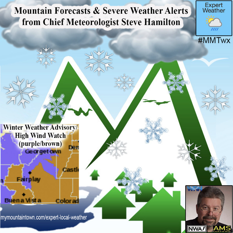
Winter Weather Advisory
URGENT - WINTER WEATHER MESSAGE
National Weather Service Denver/Boulder CO
322 AM MST Fri Nov 13 2020
COZ031-033-034-140000-
/O.NEW.KBOU.WW.Y.0027.201114T0400Z-201115T0300Z/
West Jackson and West Grand Counties Above 9000 Feet-
South and East Jackson/Larimer/North and Northeast Grand/Northwest Boulder Counties Above 9000 Feet-
South and Southeast Grand/West Central and Southwest Boulder/Gilpin/
Clear Creek/Summit/North and West Park Counties Above 9000 Feet-
Including Mt Zirkel, Cameron Pass, Laramie and Medicine Bow Mountains, Rabbit Ears Range, Rocky Mountain National Park, Willow Creek Pass,
Berthoud Pass, Breckenridge, East Slopes Mosquito Range, East Slopes Southern Gore Range, Eisenhower Tunnel, Indian Peaks, Kenosha Mountains, Mount Evans, Williams Fork Mountains, and Winter Park
322 AM MST Fri Nov 13 2020
...
WINTER WEATHER ADVISORY IN EFFECT FROM 9 PM THIS EVENING TO 8 PM MST SATURDAY...
* WHAT...Snow expected.
Total snow accumulations of 4 to 10 inches, with locally higher amounts up to 12 inches. Winds gusting as high as 65 mph, strongest above timberline and exposed eastern slopes.
* WHERE...East Slopes Park and Northern Gore Ranges, Gore Pass, Rabbit Ears Pass, Rocky Mountain National Park and the Medicine Bow Range and The Mountains of Summit County, the Mosquito Range, and the Indian Peaks.
* WHEN...From 9 PM this evening to 8 PM MST Saturday.
* IMPACTS...Travel could be very difficult. Widespread blowing snow could significantly reduce visibility. Strong winds could cause tree damage. The cold wind chills as low as 20 below zero could cause frostbite on exposed skin in as little as 30 minutes.
PRECAUTIONARY/PREPAREDNESS ACTIONS...
Slow down and use caution while traveling.
The latest road conditions for the state you are calling from can be obtained by calling 5 1 1.
_ _ _ _ _ _
_ _ _ _ _ _
_ _ _ _ _ _
_ _ _ _ _ _
_ _ _ _ _ _
_ _ _ _ _
High Wind Watch
URGENT - WEATHER MESSAGE
National Weather Service Denver/Boulder CO
328 AM MST Fri Nov 13 2020
COZ035-036-132300-
/O.CON.KBOU.HW.A.0004.201114T0400Z-201115T0400Z/
Larimer and Boulder Counties Between 6000 and 9000 Feet-
Jefferson and West Douglas Counties Above 6000 Feet/Gilpin/Clear Creek/Northeast Park Counties Below 9000 Feet-
Including Estes Park, Glendevey, Nederland, Red Feather Lakes,
Bailey, Central City, Evergreen, Georgetown, Idaho Springs, and Westcreek
328 AM MST Fri Nov 13 2020
...
HIGH WIND WATCH REMAINS IN EFFECT FROM THIS EVENING THROUGH SATURDAY EVENING...
* WHAT...
West winds 30 to 40 mph with gusts up to 75 mph possible.
* WHERE...The Southern Front Range Foothills and The Northern Front Range Foothills.
* WHEN...From this evening through Saturday evening.
* IMPACTS...Strong winds will blow around unsecured objects. Tree limbs could be blown down and a few power outages may result. Travel will be difficult for high profile vehicles.
* ADDITIONAL DETAILS...Snow will impact the higher elevations, which the wind will cause blowover onto the foothills. This may cause visibility reductions in blowing snow, especially after midnight.
PRECAUTIONARY/PREPAREDNESS ACTIONS...
Monitor the latest forecasts and warnings for updates on this situation. Fasten loose objects or shelter objects in a safe location prior to the onset of winds.