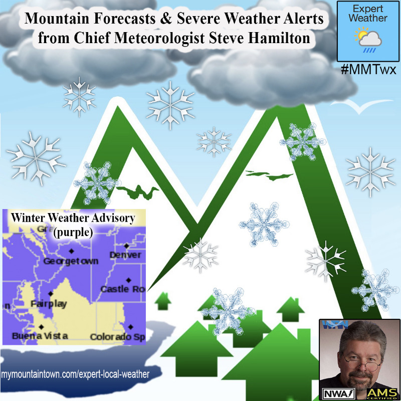
Winter Weather Advisory
URGENT - WINTER WEATHER MESSAGE
National Weather Service Denver CO
447 AM MST Sat Dec 12 2020
...ANOTHER ROUND OF SNOW HEADED TOWARDS COLORADO...
.The next storm system will begin to spread snow over the mountains this morning, then across the plains later this afternoon and tonight. Expect winter travel conditions by tonight with icy and snow packed roads. Snow will gradually diminish later tonight.
COZ034>036-122200-
/O.NEW.KBOU.WW.Y.0029.201212T1800Z-201213T0700Z/
South and Southeast Grand/West Central and Southwest Boulder/Gilpin/
Clear Creek/Summit/North and West Park Counties Above 9000 Feet-
Larimer and Boulder Counties Between 6000 and 9000 Feet-
Jefferson and West Douglas Counties Above 6000 Feet/Gilpin/Clear Creek/Northeast Park Counties Below 9000 Feet-
Including the cities of Evergreen, Georgetown, Glendevey, Estes Park, Indian Peaks, Nederland, Idaho Springs, Eisenhower Tunnel, East Slopes Southern Gore Range, Mount Evans, Central City, Red Feather Lakes, East Slopes Mosquito Range, Breckenridge, Winter Park, Williams Fork Mountains, Bailey, Kenosha Mountains, Westcreek, and Berthoud Pass
447 AM MST Sat Dec 12 2020
...
WINTER WEATHER ADVISORY IN EFFECT FROM 11 AM THIS MORNING TO MIDNIGHT MST TONIGHT...
* WHAT...Snow expected.
Total snow accumulations of 2 to 6 inches.
* WHERE...The Mountains of Summit County, the Mosquito Range, and the Indian Peaks, The Northern Front Range Foothills, and The Southern Front Range Foothills.
* WHEN...From 11 AM this morning to Midnight MST tonight.
* IMPACTS...Plan on slippery road conditions. Roads, and especially bridges and overpasses, will likely become slick and hazardous.
PRECAUTIONARY/PREPAREDNESS ACTIONS...
Slow down and use caution while traveling. The latest road conditions for the state you are calling from can be obtained by calling 5 1 1.
_ _ _ _ _ _ _ _ _ _ _ _ _ _ _ _ _ _ _ _ _ _ _ _ _ _ _ _ _ _ _ _ _ _ _ _ _ _ _ _ _ _ _ _ _ _ _ _ _
URGENT - WINTER WEATHER MESSAGE
National Weather Service Denver CO
447 AM MST Sat Dec 12 2020
COZ039>041-046-047-122200-
/O.NEW.KBOU.WW.Y.0029.201213T0000Z-201213T0900Z/
Boulder And
Jefferson Counties Below 6000 Feet/West Broomfield County-
North Douglas County Below 6000 Feet/Denver/West Adams and Arapahoe Counties/East Broomfield County-
Elbert/Central and East Douglas Counties Above 6000 Feet-
North and Northeast Elbert County Below 6000 Feet/North Lincoln County-
Southeast Elbert County Below 6000 Feet/South Lincoln County-
Including the cities of Elbert, Hugo, Arvada, Larkspur, Fondis, Forder, Boulder,
City of Denver, Aurora, Littleton, Brighton, Highlands Ranch, Matheson, Kiowa, Longmont, Agate, Kutch,
Denver International Airport, Golden, Parker, Castle Rock,
Lakewood, Karval, Punkin Center, and Limon
447 AM MST Sat Dec 12 2020
...
WINTER WEATHER ADVISORY IN EFFECT FROM 5 PM THIS AFTERNOON TO 2 AM MST SUNDAY...
* WHAT...Snow expected.
Total snow accumulations of 2 to 4 inches.
* WHERE...Boulder and the western suburbs of Denver, Denver, Castle Rock, Limon, and Southern Lincoln County.
* WHEN...From 5 PM this afternoon to 2 AM MST Sunday.
For more information from the National Weather Service, visit
weather.gov/bou
Entrekin