- Posts: 9766
- Thank you received: 221
- Forum
- Life Up the Hill
- Scanner & Emergency Info, Weather Forecasts
- USFS Pike & San Isabel National Forest South Platte District Slash Pile Burns
USFS Pike & San Isabel National Forest South Platte District Slash Pile Burns
- MountainTownAlerts
-
 Topic Author
- Mountain Legend
-

Less
More
16 Dec 2020 11:01 #1
by MountainTownAlerts
USFS Pike & San Isabel National Forest South Platte District Slash Pile Burns was created by MountainTownAlerts
From the USFS:
Good Morning,
The US Forest Service, Pike National Forest, South Platte Ranger District is planning on starting ignitions of hand created slash piles on the 12/16/2020, depending on conditions today.
The piles we are lighting today are training piles and will be out by Thursday.
Please see attached map for exact location of unit.
Test fire should start around 1000 hrs.
Smoke maybe visible throughout the day in the area.
Please Log in or Create an account to join the conversation.
- MountainTownAlerts
-
Topic Author
- Mountain Legend
-
Less
More
- Posts: 9766
- Thank you received: 221
16 Dec 2020 11:48 #2
by MountainTownAlerts
Replied by MountainTownAlerts on topic USFS Pike & San Isabel National Forest South Platte District Slash Pile Burns
An update for today's location:
Contact(s): Crystal Young
PSICC prepares for prescribed pile burningThe US Forest Service, Pike National Forest, South Platte Ranger District is planning on starting ignitions of hand created slash piles on the Payne Gulch piles, depending on conditions today.
Test fire should start around 1000 hrs.
These Piles are for training of new crew members before the new year, all piles will be called completely out by Thursday 12/17/2020
Smoke maybe visible throughout the day in the area.
Contact(s): Crystal Young
PUEBLO, Colo., Dec 4, 2020 —The Pike San Isabel National Forests Cimarron and Comanche National Grasslands is preparing for prescribed pile burning on National Forest System lands, as conditions allow.
Ignitions will take place when weather and fuel conditions are likely to produce expected fire behavior within project specific burn plan requirements that will limit substantial impacts of smoke in surrounding communities.
“Prescribed fire is an effective land management tool used to reduce the accumulation of hazardous fuels and to lessen the impacts of future wildfires,” said Bill King, fire management staff officer.
The piles consist of small trees, tops and limbs cut and piled during hazardous fuel management projects. These projects help improve forest health, minimize risk to firefighters, and improve public safety. Once ignited, burns may continue for several days to several weeks. Smoke may linger after the burn is complete and may be visible from many locations.
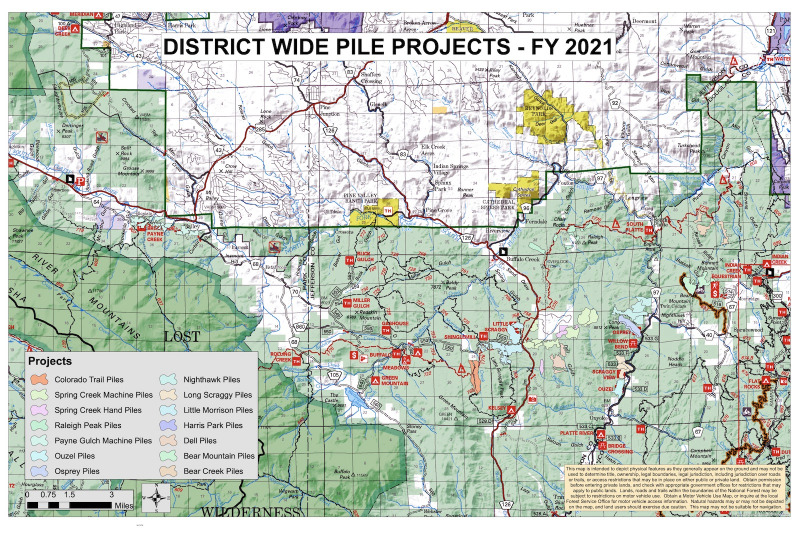
Targeted projects:
South Platte Ranger District
- Bear Creek and Bear Mountain, north of County Road 67 (Douglas County)
- Long Scraggy, Night Hawk, Osprey and Ouzel along the South Platte river corridor (Jefferson County)
- Spring Creek, Dell, Raleigh Peak and Little Morrison south of Buffalo Creek along highway 126 (Jefferson County)
- Payne Gulch, near community of Bailey (Park County)
South Park Ranger DistrictPrescribed fire smoke may affect your health. For more information about health and smoke see: www.colorado.gov/pacific/cdphe/wood-smoke-and-health . Receive notifications by following us on Twitter @PSICC_NF or by following our Alerts RSS feed here. For additional information contact Crystal Young, public affairs specialist, at 719-248-8970 or email This email address is being protected from spambots. You need JavaScript enabled to view it..
- Lake George East, surrounding the Lake George Work Center (Park County)
- County Road 98, both sides of Park County Road 98, SSW of Wagon Tongue Reservoir (Park County)
- Road Gulch, FR 240 and Park County Road 98, SSW of Wagon Tongue Reservoir (Park County)
Please Log in or Create an account to join the conversation.
- MountainTownAlerts
-
Topic Author
- Mountain Legend
-
Less
More
- Posts: 9766
- Thank you received: 221
14 Jan 2021 12:21 #3
by MountainTownAlerts
Replied by MountainTownAlerts on topic USFS Pike & San Isabel National Forest South Platte District Slash Pile Burns
From US Pike & San Isabel National Forest South Platte District:
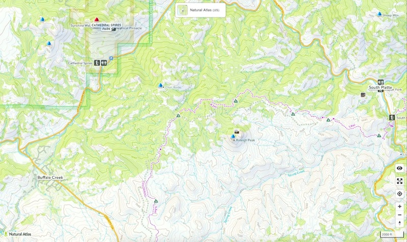
Map: peakery.com/raleigh-peak-colorado/map/
Good Morning,
The US Forest Service, Pike National Forest, South Platte Ranger District is planning on starting ignitions of hand created slash piles at Raleigh peak on 1/14/2021, depending on conditions today.
Test fire should start around 1000 hrs.
Smoke maybe visible throughout the day in the area.
Map: peakery.com/raleigh-peak-colorado/map/
Please Log in or Create an account to join the conversation.
- MountainTownAlerts
-
Topic Author
- Mountain Legend
-
Less
More
- Posts: 9766
- Thank you received: 221
15 Jan 2021 10:01 #4
by MountainTownAlerts
Replied by MountainTownAlerts on topic USFS Pike & San Isabel National Forest South Platte District Slash Pile Burns
Good Morning,
The US Forest Service, Pike National Forest, South Platte Ranger District is planning on starting ignitions of hand created slash piles at Raleigh peak on the 1/14/2021, depending on conditions today.
Please see map [above, in original post in this topic] for exact location of unit. (River Central)
Test fire should start around 1000 hrs with Mod 11-Bravo
Smoke maybe visible throughout the day in the area.
Please Log in or Create an account to join the conversation.
- MountainTownAlerts
-
Topic Author
- Mountain Legend
-
Less
More
- Posts: 9766
- Thank you received: 221
17 Jan 2021 09:24 #5
by MountainTownAlerts
Replied by MountainTownAlerts on topic USFS Pike & San Isabel National Forest South Platte District Slash Pile Burns
From PSICC:
Good Morning,
The US Forest Service, Pike National Forest, South Platte Ranger District is planning on starting ignitions of hand created slash piles on Raleigh Peak RX the 1/17/2021, depending on conditions today.
Test fire should start around 1000 hrs.
Smoke maybe visible throughout the day in the area.
Please Log in or Create an account to join the conversation.
- MountainTownAlerts
-
Topic Author
- Mountain Legend
-
Less
More
- Posts: 9766
- Thank you received: 221
26 Jan 2021 10:02 #6
by MountainTownAlerts
Replied by MountainTownAlerts on topic USFS Pike & San Isabel National Forest South Platte District Slash Pile Burns
From USFS:
Good Morning,
The US Forest Service, Pike National Forest, South Platte Ranger District is planning on starting ignitions of hand created slash piles at Raleigh Peak on 01/26/2021, depending on conditions today.
Test fire should start around 1000 hrs.
Smoke maybe visible throughout the day in the area.
Please Log in or Create an account to join the conversation.
- MountainTownAlerts
-
Topic Author
- Mountain Legend
-
Less
More
- Posts: 9766
- Thank you received: 221
17 Mar 2021 08:16 #7
by MountainTownAlerts
Replied by MountainTownAlerts on topic USFS Pike & San Isabel National Forest South Platte District Slash Pile Burns
From the USFS:
Good Morning,
The US Forest Service, Pike National Forest, South Platte Ranger District is planning on starting ignitions of hand created slash piles on Spring Creek Hand Pile RX on 03/17/2021, depending on conditions today.
Please see attached map for exact location of unit.
Test fire should start around 1000 hrs.
Smoke maybe visible throughout the day in the area.
Please Log in or Create an account to join the conversation.
- MountainTownAlerts
-
Topic Author
- Mountain Legend
-
Less
More
- Posts: 9766
- Thank you received: 221
21 Mar 2021 17:49 #8
by MountainTownAlerts
Replied by MountainTownAlerts on topic USFS Pike & San Isabel National Forest South Platte District Slash Pile Burns
Date: Sunday March 21, 2021
Location: Spring Creek Machine Piles and Spring Creek Hand Piles
Patrol conducted by: Mod 11A
Number of Piles Burned checked: 150 Machine Piles + 100 Hand piles
Acres Burned checked: 290 Acres Machine Piles and 5 Acres Hand Piles
Consumption % of piles: 90%
Number of piles still smoldering: 15
Creeping beyond radiant heat footprint: No
Potential Smoke impacts to smoke receptors (i.e. highways and/or communities): Buffalo Creek, Spring Creek subdivision
Fuels surrounding piles are not anticipated to support fire: No
Patrol Status: Mod 11 will conduct patrols until all piles are called out.
Patrol needs for next operational period: Patrol/Monitor
Additional Comments: Smoke may be visible in the area and Firefighters monitor the area after burning is complete. Public and firefighter safety is always the number-one priority in burning operations. Seeing flames and smoke, even after dark, is part of normal operations. This reduces fuels on the landscape under the safest conditions. If you see alarming smoke or flames, please contact Pueblo Interagency Dispatch Center at (719) 553-1600.
Please Log in or Create an account to join the conversation.
- MountainTownAlerts
-
Topic Author
- Mountain Legend
-
Less
More
- Posts: 9766
- Thank you received: 221
08 Apr 2021 09:47 #9
by MountainTownAlerts
Replied by MountainTownAlerts on topic USFS Pike & San Isabel National Forest South Platte District Slash Pile Burns
Forest Service News Release
Public Affairs Specialist: Crystal Young
(719) 248-8970
This email address is being protected from spambots. You need JavaScript enabled to view it.
www.fs.usda.gov/psicc
Prescribed burning continues near Sand Springs
PUEBLO, Colo., April 8, 2021— The South Platte Ranger District of the Pike and San Isabel National Forests Cimarron and Comanche National Grasslands plans to burn up to 389 acres within the Sand Springs project area of Jefferson County when forest vegetation and weather conditions allow in the between April – May 2021.
The Sand Springs project area is located at the junction of County Road 126 and Forest Service Road 550 and is a continuation of hazardous fuels management projects implemented to improve forest health, minimize the risk to firefighters, and improve public safety. Prescribed fire is an effective land management tool used to reduce the accumulation of hazardous fuels and to lessen the impacts of future wildfires.
Ignitions will take place when weather and fuel conditions are such that the fire behavior will be within the burn plan limitations and substantial smoke impacts are unlikely to affect the surrounding communities. If burning does take place, it may continue from several days to several weeks. Smoke may linger in the air after ignition is completed and be visible from many locations surrounding the area.
Prescribed fire smoke may affect your health. For more information see: www.colorado.gov/pacific/cdphe/wood-smoke-and-health .
For additional information, follow us on Twitter @PSICC_NF, #SouthPlatteRD #SandSpringsRX or call the District Fire Management Officer Joe Sean Kennedy at 303-275-5632 or email This email address is being protected from spambots. You need JavaScript enabled to view it..
If you would like to sign up to be notified prior to implementation of Prescribed Fires on the South Platte RD via email please click: bit.ly/3aGWC7o . Members of the public who have previously signed up will receive email notifications prior to implementation.
###
USDA is an equal opportunity provider, employer and lender.
Please Log in or Create an account to join the conversation.
- Forum
- Life Up the Hill
- Scanner & Emergency Info, Weather Forecasts
- USFS Pike & San Isabel National Forest South Platte District Slash Pile Burns
Time to create page: 0.201 seconds
sponsors


