My Mountain Town Weather: UPDATE from Chief Meteorologist Steve Hamilton:
WINTER WEATHER ADVISORY: 8 a.m. Monday until Noon Tuesday...
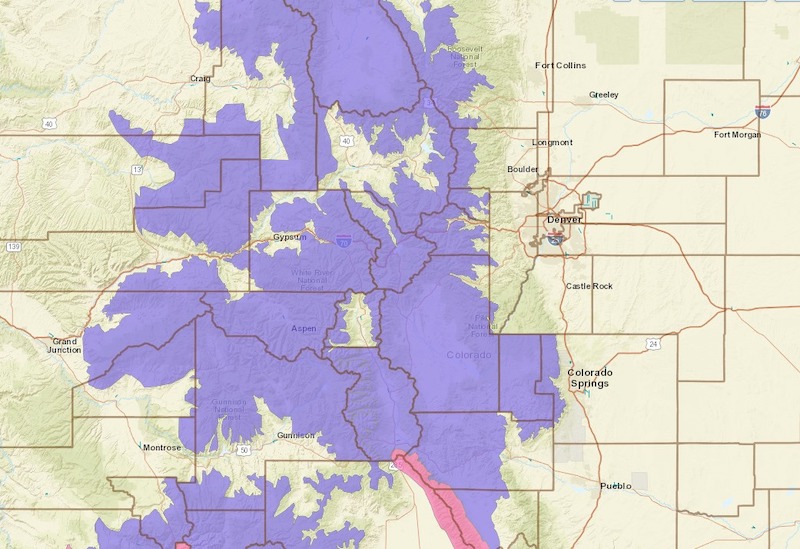
The advisory covers our following Mountain Towns: Fairplay, Alma, Jefferson, Como, Lake George, Hartsel and Guffey. Lesser snow amounts are expected for the rest of our coverage area, although roads are likely to be slick.
Accumulations of 3 to 6 inches are expected in parts of the foothills, especially Fairplay and Alma, where we may see over 10 inches. Mountain accumulations should be 6 to 12 inches.
Temperatures will remain cold for most of the week, so snow and icy spots may linger on roadways.
We have local estimates for accumulations here, along with our interactive radar, and analysis:
mymountaintown.com/expert-local-weather
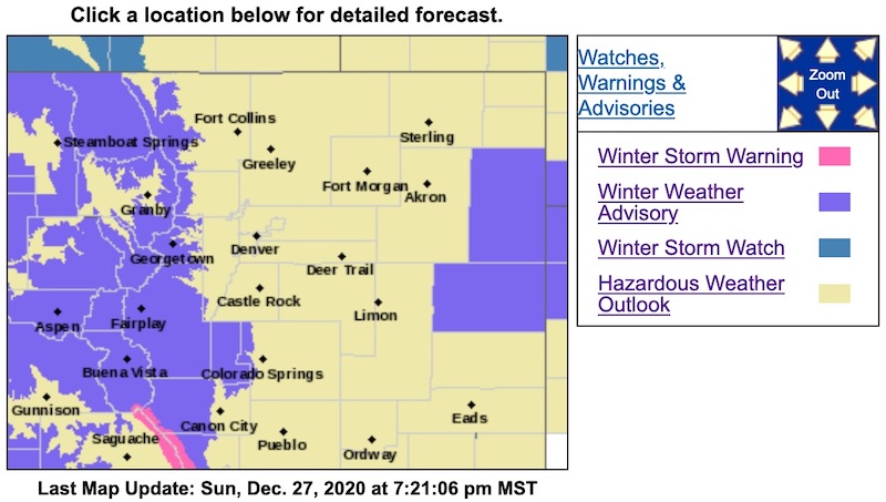
Winter Weather Advisory
URGENT - WINTER WEATHER MESSAGE
National Weather Service Denver CO
214 PM MST Sun Dec 27 2020
COZ030-031-033-034-037-280515-
/O.NEW.KBOU.WW.Y.0031.201228T1500Z-201229T1900Z/
Jackson County Below 9000 Feet-West Jackson and West Grand Counties Above 9000 Feet-
South and East Jackson/Larimer/North and Northeast Grand/Northwest Boulder Counties Above 9000 Feet-
South and Southeast Grand/West Central and Southwest Boulder/Gilpin/
Clear Creek/Summit/North and West Park Counties Above 9000 Feet-
Central and Southeast Park County-
Including the cities of North Park, Hartsel, Rocky Mountain National Park, Mt Zirkel, Laramie and Medicine Bow Mountains,
Breckenridge, Williams Fork Mountains, Indian Peaks, Eisenhower Tunnel, East Slopes Southern Gore Range, Mount Evans, Fairplay, Cameron Pass, East Slopes Mosquito Range, Berthoud Pass, Winter Park, South Park, Kenosha Mountains, Gould, Willow Creek Pass, Spicer, Rand, Walden,
Lake George, and Rabbit Ears Range
214 PM MST Sun Dec 27 2020
...
WINTER WEATHER ADVISORY IN EFFECT FROM 8 AM MONDAY TO NOON MST TUESDAY...
* WHAT...Snow.
Snow accumulations of 3 to 6 inches in the mountain valleys. Snowfall totals of 6 to 12 inches for the mountains, with locally higher totals possible.
* WHERE...North Park, Rabbit Ears Pass, Rocky Mountain National Park and the Medicine Bow Range, The Mountains of Summit County, the Mosquito Range, the Indian Peaks, and South Park.
* WHEN...From 8 AM Monday to Noon MST Tuesday.
* IMPACTS...Travel could be difficult. Snow covered roads will produce hazardous driving conditions across the area Monday into Tuesday.
PRECAUTIONARY/PREPAREDNESS ACTIONS...
Slow down and use caution while traveling. The latest road conditions for the state you are calling from can be obtained by calling 5 1 1.
For more information from the National Weather Service, visit
weather.gov/bou