High Wind Warning
URGENT - WEATHER MESSAGE
National Weather Service Denver/Boulder CO
146 AM MST Wed Jan 13 2021
...HIGH WINDS ACROSS THE FOOTHILLS STARTING LATE TODAY AND ON THE PLAINS STARTING EARLY THURSDAY...
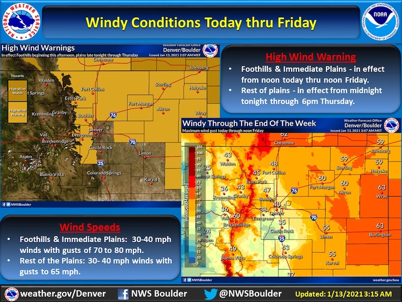
It will become windy in the mountains this afternoon, with the winds becoming stronger overnight as a cold front moves through the region. The strong winds will spread across the plains tonight as the cold front moves through. It will remain windy across these areas through Friday, but the greatest threat of high winds will be Thursday morning.
Residents should prepare for a long windy period. Secure loose objects and consider removing outdoor holiday decorations. Prepare for possible power outages. Drivers of high profile or light weight vehicles should monitor conditions and avoid travel during the windiest period which will likely be the early morning hours and during the day Thursday.
COZ035-036-038-039-131700-
/O.UPG.KBOU.HW.A.0001.210113T1900Z-210115T1900Z/
/O.NEW.KBOU.HW.W.0001.210113T1900Z-210115T1900Z/
Larimer and Boulder Counties Between 6000 and 9000 Feet-
Jefferson and West Douglas Counties Above 6000 Feet/Gilpin/Clear Creek/Northeast Park Counties Below 9000 Feet-
Larimer County Below 6000 Feet/Northwest Weld County-
Boulder And
Jefferson Counties Below 6000 Feet/West Broomfield County-
Including Estes Park, Glendevey, Nederland, Red Feather Lakes,
Bailey, Central City, Evergreen, Georgetown, Idaho Springs, Westcreek, Fort Collins, Hereford, Loveland, Nunn,
Arvada, Boulder, Golden, Lakewood, and Longmont
146 AM MST Wed Jan 13 2021
...
HIGH WIND WARNING IN EFFECT FROM NOON TODAY TO NOON MST FRIDAY...
* WHAT...Northwest winds 35 to 45 mph with gusts up to 75 mph expected.
* WHERE...The Northern Front Range Foothills, The Southern Front Range Foothills, Larimer County below 6000 feet and Northwest Weld County and Boulder and the western suburbs of Denver.
* WHEN...From noon today to noon MST Friday.
* IMPACTS...Strong winds will blow unsecured objects around. Tree limbs could be blown down and a few power outages may result. Travel will be difficult for high profile vehicles.
* ADDITIONAL DETAILS...There may be a temporary lull in the strong winds Thursday morning, before picking up again in the afternoon.
PRECAUTIONARY/PREPAREDNESS ACTIONS...
Strong winds may lead to property damage. Hazardous driving conditions due to powerful cross winds will pose a serious risk for drivers, especially for light weight and high profile vehicles. Loose outdoor items should be brought inside or secured properly.