URGENT: My Mountain Town Weather from Chief Meteorologist Steve Hamilton:
Batten Down The Hatches - High Wind Warning
The National Weather Service in Boulder has issued a High Wind Warning, in effect from 2:00 AM to 5:00 PM Wednesday.
West winds of 35 to 45 mph, with gusts as high as 75 mph are expected. This impacts the Northern and Southern Front Range Foothills. Strong winds will blow unsecured objects around. Tree limbs could be blown down and a few power outages will be possible. Travel will be difficult for high profile vehicles.
My Mountain Town Weather: High Wind Warning Until 5 PM Wednesday...
We'll have a strong high pressure system moving into the Central Rockies on Wednesday. The result will be a steep pressure gradient over the Front Range Foothills. So, the National Weather Service has a High Wind Warning in effect until 5 PM Wednesday for many of our mountain towns. Gusts will be in the 40-45 mph range, but stronger gusts will be possible, especially in wind-prone areas. As for the precipitation possibilities, things look dry through Friday. The next system arrives from the southwest late Friday, and may bring us rain or snow Saturday into Sunday.
mymountaintown.com/expert-local-weather
High Wind Warning
URGENT - WEATHER MESSAGE
National Weather Service Denver/Boulder CO
830 PM MST Tue Jan 19 2021
COZ035-036-201130-
/O.CON.KBOU.HW.W.0002.210120T0900Z-210121T0000Z/
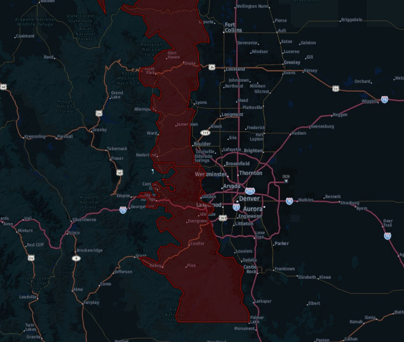
Larimer and Boulder Counties Between 6000 and 9000 Feet-
Jefferson and West Douglas Counties Above 6000 Feet/Gilpin/Clear Creek/Northeast Park Counties Below 9000 Feet-
Including Estes Park, Glendevey, Nederland, Red Feather Lakes,
Bailey, Central City, Evergreen, Georgetown, Idaho Springs, and Westcreek
830 PM MST Tue Jan 19 2021
...HIGH WIND WARNING REMAINS IN EFFECT FROM 2 AM TO 5 PM MST WEDNESDAY...
* WHAT...
West winds 35 to 45 mph with gusts up to 75 mph expected.
* WHERE...The Northern Front Range Foothills and The Southern Front Range Foothills.
* WHEN...
From 2 AM to 5 PM MST Wednesday.
* IMPACTS...Strong winds will blow unsecured objects around. Tree limbs could be blown down and a few power outages may result. Travel will be difficult for high profile vehicles.
PRECAUTIONARY/PREPAREDNESS ACTIONS...
Strong winds may lead to property damage. Hazardous driving conditions due to powerful cross winds will pose a serious risk for drivers, especially for light weight and high profile vehicles. Loose outdoor items should be brought inside or secured properly.