From Chief Meteorologist Steve Hamilton:
UPDATE: My Mountain Town Weather...
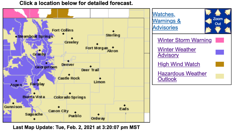
Winter Weather Advisory: 6 a.m. Wednesday to 9 a.m. Thursday
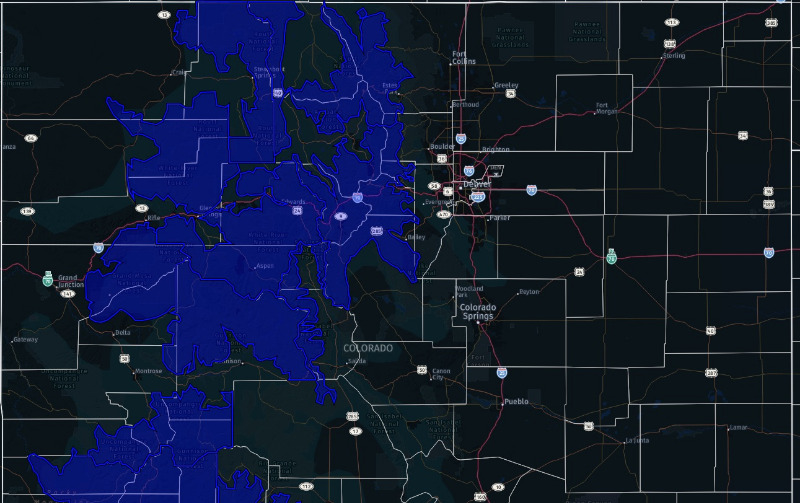
This includes Fairplay, Jefferson, Como and Alma as well as Rabbit Ears Pass, Rocky Mountain National Park, Medicine Bow Range, Summit County Mountains, Mosquito Range and Indian Peaks.
Snow and blowing snow are expected, with a strong cold front moving through Colorado overnight. 5 to 12 inches of snow will be possible, with 2 to 4 inches in the Fairplay and Alma areas.
Prepare for winter driving conditions.
Watch for updates, and developing weather using our interactive radar, on our
Weather Forecasts Page
Winter Weather Advisory
URGENT - WINTER WEATHER MESSAGE
National Weather Service Denver CO
1143 AM MST Tue Feb 2 2021
...SNOW AND BLOWING SNOW HEADED FOR THE MOUNTAINS WEDNESDAY AND WEDNESDAY NIGHT...
.A storm system will move into Colorado Wednesday morning with strong winds and increasing snow across the mountains during the day. The heaviest snow is expected to develop late Wednesday afternoon and evening as a cold front sweeps across the area. This will likely be accompanied by strong and gusty winds, creating a period of poor visibility and difficult travel conditions in the Colorado high country. Conditions are then expected to slowly improve late Wednesday night into Thursday morning as snow and winds decrease.
COZ031-033-034-030400-
/O.CON.KBOU.WW.Y.0005.210203T1300Z-210204T1600Z/
West Jackson and West Grand Counties Above 9000 Feet-
South and East Jackson/Larimer/North and Northeast Grand/Northwest Boulder Counties Above 9000 Feet-
South and Southeast Grand/West Central and Southwest Boulder/Gilpin/
Clear Creek/Summit/North and West Park Counties Above 9000 Feet-
Including the cities of East Slopes Mosquito Range, Indian Peaks, Eisenhower Tunnel, Rocky Mountain National Park, East Slopes Southern Gore Range, Mt Zirkel,
Mount Evans, Laramie and Medicine Bow Mountains, Cameron Pass,
Breckenridge, Kenosha Mountains, Winter Park, Williams Fork Mountains, Willow Creek Pass, Rabbit Ears Range, and Berthoud Pass
1143 AM MST Tue Feb 2 2021
...
WINTER WEATHER ADVISORY REMAINS IN EFFECT FROM 6 AM WEDNESDAY TO 9 AM MST THURSDAY...
* WHAT...Snow and blowing snow expected. The snow may be heavy at times late Wednesday afternoon and evening, with total snow accumulations of 5 to 12 inches.
Winds gusting up to 60 mph.
* WHERE...Rabbit Ears Pass, Rocky Mountain National Park and the Medicine Bow Range, and The Mountains of Summit County, the Mosquito Range, and the Indian Peaks.
* WHEN...From 6 AM Wednesday to 9 AM MST Thursday.
* IMPACTS...Travel could be very difficult throughout the day and evening. The hazardous conditions will likely impact the Wednesday evening commute the most.
PRECAUTIONARY/PREPAREDNESS ACTIONS...
Try to avoid travel in the mountains late Wednesday afternoon and evening. The latest road conditions for the state you are calling from can be obtained by calling 5 1 1.