URGENT - WINTER WEATHER MESSAGE
National Weather Service Denver/Boulder CO
1218 PM MST Sat Feb 13 2021
COZ038>041-043-045-140600-
/O.EXA.KBOU.WC.Y.0002.000000T0000Z-210215T1800Z/
/O.CON.KBOU.WW.Y.0011.210214T0000Z-210214T1800Z/
Larimer County Below 6000 Feet/Northwest Weld County-
Boulder And
Jefferson Counties Below 6000 Feet/West Broomfield County-
North Douglas County Below 6000 Feet/Denver/West Adams and Arapahoe Counties/East Broomfield County-
Elbert/Central and East Douglas Counties Above 6000 Feet-
Central and South Weld County-
Central and East Adams and Arapahoe Counties-
Including Fort Collins, Hereford, Loveland, Nunn, Arvada, Boulder, Golden, Lakewood, Longmont, Aurora, Brighton, City of Denver, Denver International Airport, Highlands Ranch, Littleton, Parker, Castle Rock, Elbert, Fondis, Kiowa, Larkspur, Eaton, Fort Lupton, Greeley, Roggen, Bennett, Byers, Deer Trail, and Leader
1218 PM MST Sat Feb 13 2021
...
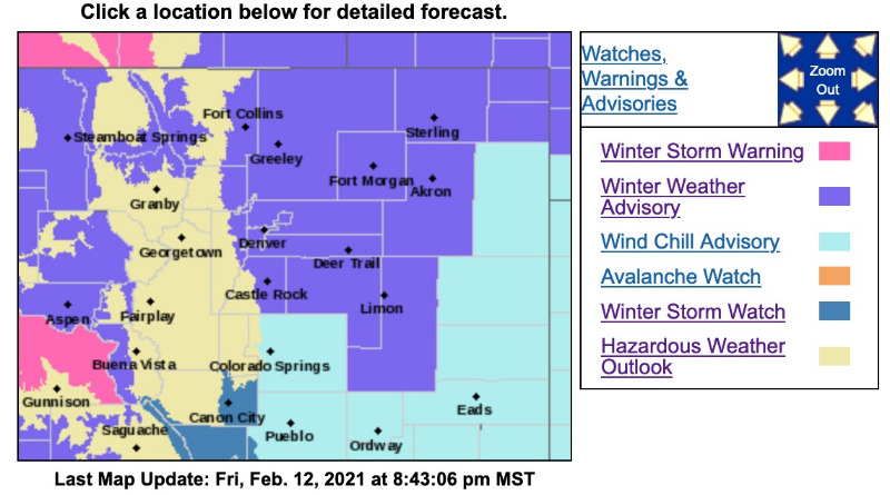
WIND CHILL ADVISORY IN EFFECT UNTIL 11 AM MST MONDAY...
...
WINTER WEATHER ADVISORY REMAINS IN EFFECT FROM 5 PM THIS AFTERNOON TO 11 AM MST SUNDAY...
* WHAT...For the Winter Weather Advisory, snow expected. Total snow accumulations of 3 to 6 inches. For the Wind Chill Advisory, very cold wind chills. Wind chills as low as 25 below zero.
* WHERE...Portions of north central and northeast Colorado.
* WHEN...For the Wind Chill Advisory, until 11 AM MST Monday. For the Winter Weather Advisory, from 5 PM this afternoon to 11 AM MST Sunday.
* IMPACTS...
Plan on slippery road conditions. The dangerously cold wind chills could cause frostbite on exposed skin in as little as 10 minutes. Frostbite and hypothermia are possible if precautions are not taken. Roads will likely become slick and hazardous.
PRECAUTIONARY/PREPAREDNESS ACTIONS...
Slow down and use caution while traveling.
Use caution while traveling outside. Wear appropriate clothing, a hat, and gloves.
The latest road conditions for the state you are calling from can be obtained by calling 5 1 1.
_ _ _ _ _ _
_ _ _ _ _ _
_ _ _ _ _ _
_ _ _ _ _ _
_ _ _ _ _ _
URGENT - WINTER WEATHER MESSAGE
National Weather Service Denver/Boulder CO
1218 PM MST Sat Feb 13 2021
COZ031-033-034-140600-
/O.CON.KBOU.WW.Y.0011.000000T0000Z-210214T1800Z/
West Jackson and West Grand Counties Above 9000 Feet-
South and East Jackson/Larimer/North and Northeast Grand/ Northwest Boulder Counties Above 9000 Feet-
South and Southeast Grand/West Central and Southwest Boulder/Gilpin/
Clear Creek/Summit/North and West Park Counties Above 9000 Feet-
Including Mt Zirkel, Cameron Pass, Laramie and Medicine Bow Mountains, Rabbit Ears Range, Rocky Mountain National Park, Willow Creek Pass,
Berthoud Pass, Breckenridge, East Slopes Mosquito Range, East Slopes Southern Gore Range, Eisenhower Tunnel, Indian Peaks, Kenosha Mountains, Mount Evans, Williams Fork Mountains, and Winter Park
1218 PM MST Sat Feb 13 2021
...
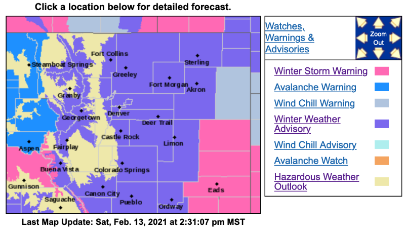
WINTER WEATHER ADVISORY REMAINS IN EFFECT UNTIL 11 AM MST SUNDAY...
* WHAT...Snow expected.
Total snow accumulations of 4 to 9 inches.
* WHERE...East Slopes Park and Northern Gore Ranges, Gore Pass, Rabbit Ears Pass, Rocky Mountain National Park and the Medicine Bow Range and The Mountains of Summit County, the Mosquito Range, and the Indian Peaks.
* WHEN...From noon today to 11 AM MST Sunday.
* IMPACTS...Plan on slippery road conditions. Roads will likely become slick and hazardous.
PRECAUTIONARY/PREPAREDNESS ACTIONS...
Slow down and use caution while traveling.
The latest road conditions for the state you are calling from can be obtained by calling 5 1 1.