- Posts: 9708
- Thank you received: 220
- Forum
- Life Up the Hill
- Scanner & Emergency Info, Weather Forecasts
- Winter Weather Advisory February 24-25th
Winter Weather Advisory February 24-25th
- MountainTownAlerts
-
 Topic Author
- Mountain Legend
-

Less
More
23 Feb 2021 20:04 #1
by MountainTownAlerts
Winter Weather Advisory February 24-25th was created by MountainTownAlerts
From Chief Meteorologist Steve Hamilton:
UPDATE: My Mountain Town Weather:
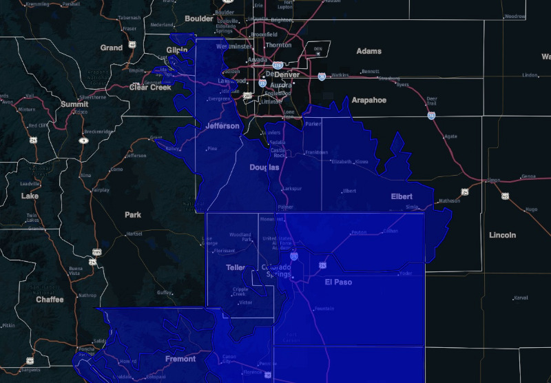
The National Weather Service in Boulder has issued a Winter Weather Advisory, in effect from 5:00 PM Wednesday until 6:00 AM Thursday, (blue highlighted area on map).
Upslope surface flow, and some mid-level moisture will combine to bring the potential for accumulating snowfall. Current total estimates (NWS) are 4 to 8 inches by early Thursday morning.
Prep for winter driving conditions and slick roads.
Details for each of our mountain towns plus interactive radar: mymountaintown.com/expert-local-weather
Winter Weather Advisory
URGENT - WINTER WEATHER MESSAGE
National Weather Service Denver CO
235 PM MST Tue Feb 23 2021
.A fast moving system will bring snow to the region starting Wednesday early evening and continuing into the early morning hours on Thursday. At this time the Southern Front Range Foothills could see 5 to 8 inches with the Palmer Divide to include the Castle Rock area getting up to 4 inches by Thursday morning. Slick roads will be possible for early morning commuters.
COZ036-041-241215-
/O.NEW.KBOU.WW.Y.0015.210225T0000Z-210225T1300Z/
Jefferson and West Douglas Counties Above 6000 Feet/Gilpin/Clear Creek/Northeast Park Counties Below 9000 Feet-
Elbert/Central and East Douglas Counties Above 6000 Feet-
Including the cities of Evergreen, Georgetown, Larkspur, Castle Rock, Elbert, Westcreek, Central City, Kiowa, Idaho Springs, Bailey, and Fondis
235 PM MST Tue Feb 23 2021
...WINTER WEATHER ADVISORY IN EFFECT FROM 5 PM WEDNESDAY TO 6 AM MST THURSDAY...
* WHAT...Snow expected. Total snow accumulations between 4 to 8 inches.
* WHERE...The Southern Front Range Foothills, and Castle Rock.
* WHEN...From 5 PM Wednesday to 6 AM MST Thursday.
* IMPACTS...Travel could be very difficult. The hazardous conditions could impact the Wednesday evening commute. Roads will likely become slick and hazardous.
PRECAUTIONARY/PREPAREDNESS ACTIONS...
Slow down and use caution while traveling. The latest road conditions for Colorado can be obtained by calling 5 1 1 or by going to www.cotrip.org
For more information from the National Weather Service, visit weather.gov/bou
Please Log in or Create an account to join the conversation.
- Forum
- Life Up the Hill
- Scanner & Emergency Info, Weather Forecasts
- Winter Weather Advisory February 24-25th
Time to create page: 0.147 seconds


