- Posts: 9766
- Thank you received: 221
- Forum
- Life Up the Hill
- Scanner & Emergency Info, Weather Forecasts
- Winter Storm Watch posted March 11, 2021
Winter Storm Watch posted March 11, 2021
- MountainTownAlerts
-
 Topic Author
- Mountain Legend
-

Less
More
11 Mar 2021 11:35 #1
by MountainTownAlerts
Winter Storm Watch posted March 11, 2021 was created by MountainTownAlerts
Preparing for Winter in the Mountains: Tips and Advice
from Ready.gov, CDOT, Weather Underground, NWS, CSP and more.
My Mountain Town Weather from Chief Meteorologist Steve Hamilton: Winter Storm Watch...
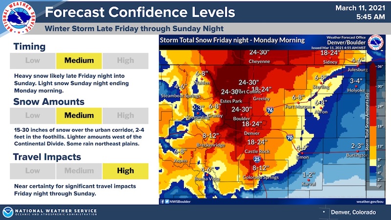
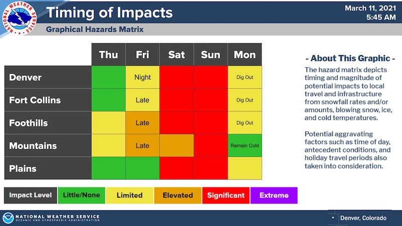
We may see some rain and snow showers Thursday and Thursday night. This will be preliminary action before the main storm arrives Friday afternoon. We may see some light accumulation from Thursday's precipitation, so watch for slick roads. The big storm will start spreading snow across our area by Friday afternoon, and should continue through Sunday. There will be areas of heavy snowfall mixed in, especially Saturday night. We have regional accumulation estimates of 1 to 3 feet in the foothills, and 1 to 2 feet in the adjacent Denver area and Palmer Divide. Local accumulation estimates will be available late Thursday, but the overall estimate gives you a good idea of what to prepare for.
These estimates will likely change Thursday and Friday with revised forecast model data. Travel will be very difficult from late Friday night through late Sunday. Gusty winds of 20 to 35 mph will accompany the snowfall.
Check our mountain town forecasts and interactive radar from Zoom Radar here: mymountaintown.com/expert-local-weather
**Please note: The Denver NEXRAD Radar will only be transmitting partial data until Monday due to technical issues.**
www.weather.gov/bou/weatherstory
Just for curiosity, we're posting the most recent drought monitor report. Let's see what happens after this!
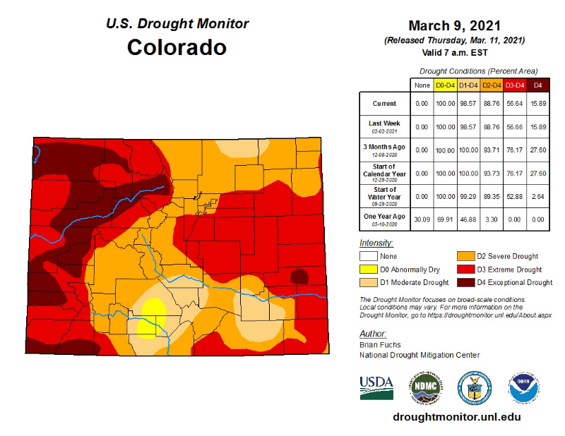
droughtmonitor.unl.edu/CurrentMap/StateDroughtMonitor.aspx?CO
My Mountain Town Weather from Chief Meteorologist Steve Hamilton: Winter Storm Watch...
We may see some rain and snow showers Thursday and Thursday night. This will be preliminary action before the main storm arrives Friday afternoon. We may see some light accumulation from Thursday's precipitation, so watch for slick roads. The big storm will start spreading snow across our area by Friday afternoon, and should continue through Sunday. There will be areas of heavy snowfall mixed in, especially Saturday night. We have regional accumulation estimates of 1 to 3 feet in the foothills, and 1 to 2 feet in the adjacent Denver area and Palmer Divide. Local accumulation estimates will be available late Thursday, but the overall estimate gives you a good idea of what to prepare for.
These estimates will likely change Thursday and Friday with revised forecast model data. Travel will be very difficult from late Friday night through late Sunday. Gusty winds of 20 to 35 mph will accompany the snowfall.
Check our mountain town forecasts and interactive radar from Zoom Radar here: mymountaintown.com/expert-local-weather
**Please note: The Denver NEXRAD Radar will only be transmitting partial data until Monday due to technical issues.**
www.weather.gov/bou/weatherstory
Just for curiosity, we're posting the most recent drought monitor report. Let's see what happens after this!
droughtmonitor.unl.edu/CurrentMap/StateDroughtMonitor.aspx?CO
Please Log in or Create an account to join the conversation.
- MountainTownAlerts
-
Topic Author
- Mountain Legend
-
Less
More
- Posts: 9766
- Thank you received: 221
11 Mar 2021 12:00 #2
by MountainTownAlerts
Replied by MountainTownAlerts on topic Winter Storm Watch posted March 11, 2021
CDOT @ColoradoDOT Mar 10
#Breaking #News: #CDOT strongly urges motorists to plan now & AVOID TRAVELING during a major snowstorm predicted to blanket roads along the foothills and Front Range. 1 to 3 foot of snow expected.
CDOT strongly urges motorists to plan now and AVOID TRAVELING during a major snowstorm predicted to blanket roads along the foothills and Front Range
March 10, 2021 - Statewide News
STATEWIDE — With the potential of a high-impact snow storm in the forecast this weekend, CDOT is urging motorists to keep a close watch on the weather and road conditions and plan to stay off the roads during the storm.
The forecast has a wide range of accumulations from one to three feet of snow in and around the Denver region, particularly the western and southern areas. Heavier snow may fall over the foothills and east of the Continental Divide. The most severe impacts are expected for the lower elevations. The storm is expected to hit late Friday and last through the weekend. The last time a storm like this swept the state was in 2003 with up to six feet in parts of the foothills.
Heavy accumulations are possible along I-70, I-25 and other highway corridors in the foothills and the Front Range. Heavy snow is expected along the I-70 mountain corridor to the Eisenhower Memorial Johnson Tunnel.
Here is what motorists need to know:
Stay Informed
Travelers are urged to “know before you go.” Gather information about weather forecasts and anticipated travel impacts and current road conditions prior to hitting the road. CDOT resources include:
CDOT’s Winter Wise campaign focuses on education, tools and resources to help keep drivers safe on Colorado’s winter roads. To learn more and view helpful tips for winter driving, visit winter.codot.gov. For specific information about I-70 and other highway travel conditions, motorists can call 511 or check COtrip.org. Additionally, drivers can check Twitter for up-to-date travel information via @ColoradoDOT. For more detailed information about the Traction and Passenger Vehicle Safety Laws, snowplow laws, safety stats and frequently asked questions, visit winter.codot.gov.
About CDOT
CDOT’s Whole System-Whole Safety program has one simple mission — to get everyone home safely. Our approximately 3,000 employees work tirelessly to reduce the rate and severity of crashes and improve the safety of all modes of transportation. The department manages more than 23,000 lane miles of highway, more than 3,000 bridges and 35 mountain passes. CDOT also manages grant partnerships with a range of agencies, including metropolitan planning organizations, local governments and airports. It also operates Bustang, the state-owned interregional express bus service. Gov. Jared Polis has charged CDOT to further build on the state’s intermodal mobility options.
www.codot.gov/news/2021/march-2021/state...winter-storm-warning
#Breaking #News: #CDOT strongly urges motorists to plan now & AVOID TRAVELING during a major snowstorm predicted to blanket roads along the foothills and Front Range. 1 to 3 foot of snow expected.
CDOT strongly urges motorists to plan now and AVOID TRAVELING during a major snowstorm predicted to blanket roads along the foothills and Front Range
March 10, 2021 - Statewide News
STATEWIDE — With the potential of a high-impact snow storm in the forecast this weekend, CDOT is urging motorists to keep a close watch on the weather and road conditions and plan to stay off the roads during the storm.
The forecast has a wide range of accumulations from one to three feet of snow in and around the Denver region, particularly the western and southern areas. Heavier snow may fall over the foothills and east of the Continental Divide. The most severe impacts are expected for the lower elevations. The storm is expected to hit late Friday and last through the weekend. The last time a storm like this swept the state was in 2003 with up to six feet in parts of the foothills.
Heavy accumulations are possible along I-70, I-25 and other highway corridors in the foothills and the Front Range. Heavy snow is expected along the I-70 mountain corridor to the Eisenhower Memorial Johnson Tunnel.
Here is what motorists need to know:
- If you are planning to travel the I-70 mountain corridor for a weekend in the mountains, head to your destination BEFORE the storm, before Friday evening.
- Regardless of your destination, get there before the storm hits.
- AVOID traveling on impacted roads during the storm, throughout the Denver metro area, on the I-70 Mountain Corridor and I-25 South Gap construction zone between Castle Rock and Monument. CDOT is likely to close these roadways for safety reasons depending on the severity of the storm.
- It is also possible I-70 east of Airpark Road and other roadways in the Eastern Plains may close depending on the severity of the storm.
- CDOT crews will be out in force and plowing roads, focusing on clearing I-25, I-70 and impacted interstates. They will make multiple passes on these roads during the storm and will not be able to plow the secondary routes until the worst of the storm has passed. This means many roadways could be heavily snow packed, making for hazardous driving conditions.
- During a significant and high impact snow storm, travel should be limited to emergency and essential reasons with the proper vehicle and tires for heavy snow. DO NOT ATTEMPT to drive in such weather conditions unless you have the appropriate tires with good tread. Motorists should leave ample distance behind the vehicle ahead and NOT PASS PLOWS. If you are out in the storm, have an emergency kit with blankets, food, batteries, water, a shovel and survival supplies should you get stuck or stranded.
- It’s best to STAY OFF THE ROADS DURING A HEAVY SNOW EVENT.
- For more information on preparing for the snow, chain and traction laws and other winter storm related guidance, go to winter.codot.gov
Stay Informed
Travelers are urged to “know before you go.” Gather information about weather forecasts and anticipated travel impacts and current road conditions prior to hitting the road. CDOT resources include:
- Road conditions and travel information: www.COtrip.org
- Sign up for project or travel alerts: bit.ly/COalerts
- See scheduled lane closures: codot.gov/travel/scheduled-lane-closures.html
- Connect with us on social media: Twitter @coloradodot and Facebook facebook.com/coloradodot
CDOT’s Winter Wise campaign focuses on education, tools and resources to help keep drivers safe on Colorado’s winter roads. To learn more and view helpful tips for winter driving, visit winter.codot.gov. For specific information about I-70 and other highway travel conditions, motorists can call 511 or check COtrip.org. Additionally, drivers can check Twitter for up-to-date travel information via @ColoradoDOT. For more detailed information about the Traction and Passenger Vehicle Safety Laws, snowplow laws, safety stats and frequently asked questions, visit winter.codot.gov.
About CDOT
CDOT’s Whole System-Whole Safety program has one simple mission — to get everyone home safely. Our approximately 3,000 employees work tirelessly to reduce the rate and severity of crashes and improve the safety of all modes of transportation. The department manages more than 23,000 lane miles of highway, more than 3,000 bridges and 35 mountain passes. CDOT also manages grant partnerships with a range of agencies, including metropolitan planning organizations, local governments and airports. It also operates Bustang, the state-owned interregional express bus service. Gov. Jared Polis has charged CDOT to further build on the state’s intermodal mobility options.
www.codot.gov/news/2021/march-2021/state...winter-storm-warning
Please Log in or Create an account to join the conversation.
- MountainTownAlerts
-
Topic Author
- Mountain Legend
-
Less
More
- Posts: 9766
- Thank you received: 221
11 Mar 2021 15:04 #3
by MountainTownAlerts
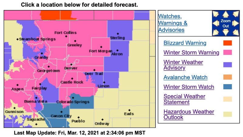
Winter Storm Warning
URGENT - WINTER WEATHER MESSAGE
National Weather Service Denver CO
229 PM MST Thu Mar 11 2021
...POWERFUL WINTER STORM ON TRACK FOR THIS WEEKEND...
.A significant late season winter storm will move across the Desert Southwest Friday to near the Four Corners region by Saturday, and then track east/northeast across southeast Colorado Sunday. This track will bring significant snowfall to much of northeast and north central Colorado, and likely result in difficult if not impossible travel from Saturday afternoon through Sunday and Sunday night. The most severe conditions from deep accumulating snow will likely occur in and near the Front Range Mountains and Foothills where 2 to 4 feet of snow may fall, and along the I-25 Urban Corridor where up to 2 feet of snow can be expected. Temperatures will be warm enough to bring a mix of rain and snow to areas east of a Greeley to Limon line Saturday into Saturday evening, but temperatures should turn cold enough there Saturday night into Sunday for mostly snow. Winds are also expected to increase by Sunday, with blowing and drifting snow developing across the plains.
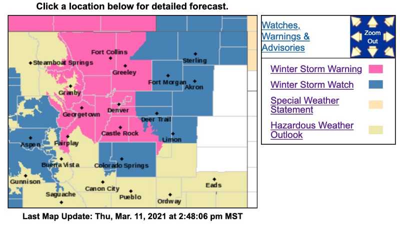
COZ033>036-121200-
/O.UPG.KBOU.WS.A.0001.210313T0000Z-210315T1200Z/
/O.NEW.KBOU.WS.W.0004.210313T0700Z-210315T1200Z/
South and East Jackson/Larimer/North and Northeast Grand/Northwest Boulder Counties Above 9000 Feet-
South and Southeast Grand/West Central and Southwest Boulder/Gilpin/Clear Creek/Summit/North and West Park Counties Above 9000 Feet-
Larimer and Boulder Counties Between 6000 and 9000 Feet-
Jefferson and West Douglas Counties Above 6000 Feet/Gilpin/Clear Creek/Northeast Park Counties Below 9000 Feet-
Including the cities of Winter Park, Westcreek, Rocky Mountain National Park, Central City, Red Feather Lakes, Breckenridge, Bailey, Williams Fork Mountains, Evergreen, Georgetown, Glendevey, Indian Peaks, Nederland, Eisenhower Tunnel, East Slopes Southern Gore Range, Mount Evans, Cameron Pass, East Slopes Mosquito Range, Berthoud Pass, Kenosha Mountains, Estes Park, Willow Creek Pass, Laramie and Medicine Bow Mountains, Idaho Springs, and Rabbit Ears Range
229 PM MST Thu Mar 11 2021
...WINTER STORM WARNING IN EFFECT FROM MIDNIGHT MST FRIDAY NIGHT TO 6 AM MDT MONDAY...
* WHAT...Heavy snow. Total snow accumulations of 2 to 4 feet possible, except 10 to 20 inches possible west of the Eisenhower Tunnel. Winds could gust as high as 35 mph.
* WHERE...Rocky Mountain National Park and the Medicine Bow Range, The Mountains of Summit County, the Mosquito Range, and the Indian Peaks, The Northern Front Range Foothills, and The Southern Front Range Foothills.
* WHEN...From Midnight MST Friday Night to 6 AM MDT Monday.
* IMPACTS...Travel could be impossible due to the depth of the accumulating snow.
* ADDITIONAL DETAILS...Finish preparations for this storm by Friday.
PRECAUTIONARY/PREPAREDNESS ACTIONS...
If you must travel, keep an extra flashlight, food, and water in your vehicle in case of an emergency. The latest road conditions for Colorado can be obtained by calling 5 1 1 or by going to www.cotrip.org
_ _ _ _ _ _ _ _ _ _ _ _ _ _ _ _ _ _ _ _ _ _ _ _ _ _ _ _ _ _ _ _ _ _ _ _ _ _ _ _ _ _ _ _
URGENT - WINTER WEATHER MESSAGE
National Weather Service Denver CO
229 PM MST Thu Mar 11 2021
...POWERFUL WINTER STORM ON TRACK FOR THIS WEEKEND...
COZ038>041-043-121200-
/O.UPG.KBOU.WS.A.0001.210313T0700Z-210315T1200Z/
/O.NEW.KBOU.WS.W.0004.210313T1200Z-210315T1200Z/
Larimer County Below 6000 Feet/Northwest Weld County-
Boulder And Jefferson Counties Below 6000 Feet/West Broomfield County-
North Douglas County Below 6000 Feet/Denver/West Adams and Arapahoe Counties/East Broomfield County-
Elbert/Central and East Douglas Counties Above 6000 Feet-
Central and South Weld County-
Including the cities of Elbert, Roggen, Arvada, Larkspur, Boulder, City of Denver, Aurora, Littleton, Brighton, Highlands Ranch, Fort Lupton, Loveland, Kiowa, Eaton, Longmont, Fondis, Denver International Airport, Golden, Parker, Castle Rock, Lakewood, Fort Collins, Greeley, Nunn, and Hereford
229 PM MST Thu Mar 11 2021
...WINTER STORM WARNING IN EFFECT FROM 5 AM MST SATURDAY TO 6 AM MDT MONDAY...
* WHAT...Heavy snow possible. Total snow accumulations of 14 to 24 inches possible. Accumulations up to 30 inches possible near Boulder and Fort Collins. Winds could gust as high as 35 mph.
* WHERE...Fort Collins, Boulder and the western suburbs of Denver, Denver, Castle Rock, and Greeley.
* WHEN...From 5 AM MST Saturday to 6 AM MDT Monday.
* IMPACTS...Travel could be very difficult to impossible.
* ADDITIONAL DETAILS...Finish preparation for this storm by Friday. Conditions will likely deteriorate quickly Saturday as the storm arrives.
Replied by MountainTownAlerts on topic Winter Storm Watch posted March 11, 2021
Winter Storm Warning
URGENT - WINTER WEATHER MESSAGE
National Weather Service Denver CO
229 PM MST Thu Mar 11 2021
...POWERFUL WINTER STORM ON TRACK FOR THIS WEEKEND...
.A significant late season winter storm will move across the Desert Southwest Friday to near the Four Corners region by Saturday, and then track east/northeast across southeast Colorado Sunday. This track will bring significant snowfall to much of northeast and north central Colorado, and likely result in difficult if not impossible travel from Saturday afternoon through Sunday and Sunday night. The most severe conditions from deep accumulating snow will likely occur in and near the Front Range Mountains and Foothills where 2 to 4 feet of snow may fall, and along the I-25 Urban Corridor where up to 2 feet of snow can be expected. Temperatures will be warm enough to bring a mix of rain and snow to areas east of a Greeley to Limon line Saturday into Saturday evening, but temperatures should turn cold enough there Saturday night into Sunday for mostly snow. Winds are also expected to increase by Sunday, with blowing and drifting snow developing across the plains.
COZ033>036-121200-
/O.UPG.KBOU.WS.A.0001.210313T0000Z-210315T1200Z/
/O.NEW.KBOU.WS.W.0004.210313T0700Z-210315T1200Z/
South and East Jackson/Larimer/North and Northeast Grand/Northwest Boulder Counties Above 9000 Feet-
South and Southeast Grand/West Central and Southwest Boulder/Gilpin/Clear Creek/Summit/North and West Park Counties Above 9000 Feet-
Larimer and Boulder Counties Between 6000 and 9000 Feet-
Jefferson and West Douglas Counties Above 6000 Feet/Gilpin/Clear Creek/Northeast Park Counties Below 9000 Feet-
Including the cities of Winter Park, Westcreek, Rocky Mountain National Park, Central City, Red Feather Lakes, Breckenridge, Bailey, Williams Fork Mountains, Evergreen, Georgetown, Glendevey, Indian Peaks, Nederland, Eisenhower Tunnel, East Slopes Southern Gore Range, Mount Evans, Cameron Pass, East Slopes Mosquito Range, Berthoud Pass, Kenosha Mountains, Estes Park, Willow Creek Pass, Laramie and Medicine Bow Mountains, Idaho Springs, and Rabbit Ears Range
229 PM MST Thu Mar 11 2021
...WINTER STORM WARNING IN EFFECT FROM MIDNIGHT MST FRIDAY NIGHT TO 6 AM MDT MONDAY...
* WHAT...Heavy snow. Total snow accumulations of 2 to 4 feet possible, except 10 to 20 inches possible west of the Eisenhower Tunnel. Winds could gust as high as 35 mph.
* WHERE...Rocky Mountain National Park and the Medicine Bow Range, The Mountains of Summit County, the Mosquito Range, and the Indian Peaks, The Northern Front Range Foothills, and The Southern Front Range Foothills.
* WHEN...From Midnight MST Friday Night to 6 AM MDT Monday.
* IMPACTS...Travel could be impossible due to the depth of the accumulating snow.
* ADDITIONAL DETAILS...Finish preparations for this storm by Friday.
PRECAUTIONARY/PREPAREDNESS ACTIONS...
If you must travel, keep an extra flashlight, food, and water in your vehicle in case of an emergency. The latest road conditions for Colorado can be obtained by calling 5 1 1 or by going to www.cotrip.org
_ _ _ _ _ _ _ _ _ _ _ _ _ _ _ _ _ _ _ _ _ _ _ _ _ _ _ _ _ _ _ _ _ _ _ _ _ _ _ _ _ _ _ _
URGENT - WINTER WEATHER MESSAGE
National Weather Service Denver CO
229 PM MST Thu Mar 11 2021
...POWERFUL WINTER STORM ON TRACK FOR THIS WEEKEND...
COZ038>041-043-121200-
/O.UPG.KBOU.WS.A.0001.210313T0700Z-210315T1200Z/
/O.NEW.KBOU.WS.W.0004.210313T1200Z-210315T1200Z/
Larimer County Below 6000 Feet/Northwest Weld County-
Boulder And Jefferson Counties Below 6000 Feet/West Broomfield County-
North Douglas County Below 6000 Feet/Denver/West Adams and Arapahoe Counties/East Broomfield County-
Elbert/Central and East Douglas Counties Above 6000 Feet-
Central and South Weld County-
Including the cities of Elbert, Roggen, Arvada, Larkspur, Boulder, City of Denver, Aurora, Littleton, Brighton, Highlands Ranch, Fort Lupton, Loveland, Kiowa, Eaton, Longmont, Fondis, Denver International Airport, Golden, Parker, Castle Rock, Lakewood, Fort Collins, Greeley, Nunn, and Hereford
229 PM MST Thu Mar 11 2021
...WINTER STORM WARNING IN EFFECT FROM 5 AM MST SATURDAY TO 6 AM MDT MONDAY...
* WHAT...Heavy snow possible. Total snow accumulations of 14 to 24 inches possible. Accumulations up to 30 inches possible near Boulder and Fort Collins. Winds could gust as high as 35 mph.
* WHERE...Fort Collins, Boulder and the western suburbs of Denver, Denver, Castle Rock, and Greeley.
* WHEN...From 5 AM MST Saturday to 6 AM MDT Monday.
* IMPACTS...Travel could be very difficult to impossible.
* ADDITIONAL DETAILS...Finish preparation for this storm by Friday. Conditions will likely deteriorate quickly Saturday as the storm arrives.
Please Log in or Create an account to join the conversation.
- MountainTownAlerts
-
Topic Author
- Mountain Legend
-
Less
More
- Posts: 9766
- Thank you received: 221
12 Mar 2021 15:24 - 14 Mar 2021 12:48 #4
by MountainTownAlerts
Replied by MountainTownAlerts on topic Winter Storm Watch posted March 11, 2021
Chief Meteorologist Steve Hamilton: Winter Storm Warning Until 6AM Monday...
Strong low pressure will move through the Rockies Friday through late Sunday, impacting the foothills with 1 to 3 feet of snow. The major impacts from this storm will be:
- Heavy, wet snowfall. This could cause extended power outages.
- Gusty wind. This will cause blowing and drifting snow, and poor visibility on the roads.
- Snow-packed roads. This will make travel difficult, to impossible.
- The main part of the storm will impact the foothills from late Friday night through Sunday afternoon.
Winter Storm Warning
URGENT - WINTER WEATHER MESSAGE
National Weather Service Denver CO
217 PM MST Fri Mar 12 2021
...POWERFUL WINTER STORM ON TRACK FOR THIS WEEKEND...
.A significant late season winter storm will move from the Desert Southwest to near the Four Corners region by Saturday, and then track east/northeast across southeast Colorado Sunday. This track will bring significant snowfall to much of northeast and north central Colorado, and likely result in difficult if not impossible travel from late Saturday afternoon or evening through Sunday and Sunday night. The most severe conditions from deep accumulating snow will likely occur in and near the Front Range Mountains and Foothills where 2 to 4 feet of snow may fall, and along the I-25 Urban Corridor where up to 2 feet of snow can be expected. The favored locations for the heaviest snow totals along the I-25 Corridor will be from Boulder north through the Fort Collins area. Temperatures will be warm enough to bring a mix of rain and snow to areas east of a Fort Morgan to Limon line Saturday into Saturday evening, but temperatures should turn cold enough there Saturday night into Sunday for mostly snow. Winds are also expected to increase by Sunday, with blowing and drifting snow developing across the plains.
...WINTER STORM WARNING REMAINS IN EFFECT FROM MIDNIGHT MST TONIGHT TO 6 AM MDT MONDAY...
* WHAT...Heavy snow. Total snow accumulations of 2 to 4 feet possible with the heaviest totals in the northern Front Range Foothills. Locations west of the Eisenhower Tunnel will receive 8 to 16 inches. Winds could gust as high as 35 mph.
* WHERE...Rocky Mountain National Park and the Medicine Bow Range, The Mountains of Summit County, the Mosquito Range, and the Indian Peaks, The Northern Front Range Foothills, and The Southern Front Range Foothills.
* WHEN...From Midnight MST tonight to 6 AM MDT Monday.
* IMPACTS...Travel could be impossible due to the depth of the accumulating snow.
_ _ _ _ _ _ _ _ _ _ _ _ _ _ _ _ _ _ _ _ _ _ _ _ _ _ _ _ _ _ _ _ _ _ _ _ _ _ _ _ _ _ _ _
URGENT - WINTER WEATHER MESSAGE
National Weather Service Denver CO
217 PM MST Fri Mar 12 2021
...POWERFUL WINTER STORM ON TRACK FOR THIS WEEKEND...
COZ038>041-043-130530-/O.CON.KBOU.WS.W.0004.210313T1200Z-210315T1200Z/
Larimer County Below 6000 Feet/Northwest Weld County-
Boulder And Jefferson Counties Below 6000 Feet/West Broomfield County-
North Douglas County Below 6000 Feet/Denver/West Adams and Arapahoe Counties/East Broomfield County-
Elbert/Central and East Douglas Counties Above 6000 Feet-
Central and South Weld County-
Including the cities of Elbert, Roggen, Arvada, Larkspur, Boulder, City of Denver, Aurora, Littleton, Brighton, Highlands Ranch, Fort Lupton, Loveland, Kiowa, Eaton, Longmont, Fondis, Denver International Airport, Golden, Parker, Castle Rock, Lakewood, Fort Collins, Greeley, Nunn, and Hereford
217 PM MST Fri Mar 12 2021
...WINTER STORM WARNING REMAINS IN EFFECT FROM 5 AM MST SATURDAY TO 6 AM MDT MONDAY...
* WHAT...Heavy snow expected. Total snow accumulations of 12 to 24 inches expected, with locally heavier amounts possible near Boulder and Fort Collins. Winds could gust as high as 35 mph.
* WHERE...Fort Collins, Boulder and the western suburbs of Denver, Denver, Castle Rock, and Greeley.
* WHEN...From 5 AM MST Saturday to 6 AM MDT Monday.
* IMPACTS...Travel could be very difficult to impossible.
* ADDITIONAL DETAILS...Finish preparation for this storm today. Conditions will deteriorate Saturday as the storm arrives, but the most severe conditions will likely hold off until Saturday evening.
PRECAUTIONARY/PREPAREDNESS ACTIONS...
If you must travel, keep an extra flashlight, food, and water in your vehicle in case of an emergency. The latest road conditions for Colorado can be obtained by calling 5 1 1 or by going to www.cotrip.org
Last edit: 14 Mar 2021 12:48 by MountainTownAlerts. Reason: fixed title
Please Log in or Create an account to join the conversation.
- MountainTownAlerts
-
Topic Author
- Mountain Legend
-
Less
More
- Posts: 9766
- Thank you received: 221
18 Mar 2021 13:42 #5
by MountainTownAlerts
Replied by MountainTownAlerts on topic Winter Storm Watch posted March 11, 2021
U.S. Drought Monitor report last week before the snow:
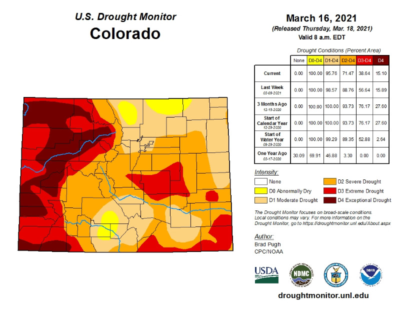
droughtmonitor.unl.edu/data/jpg/20210316/20210316_CO_trd.jpg
This week's drought levels. Nice improvement, we need more of these wet storms!MountainTownAlerts wrote: Just for curiosity, we're posting the most recent drought monitor report. Let's see what happens after this!
droughtmonitor.unl.edu/CurrentMap/StateDroughtMonitor.aspx?CO
droughtmonitor.unl.edu/data/jpg/20210316/20210316_CO_trd.jpg
Please Log in or Create an account to join the conversation.
- Forum
- Life Up the Hill
- Scanner & Emergency Info, Weather Forecasts
- Winter Storm Watch posted March 11, 2021
Time to create page: 0.324 seconds
sponsors


