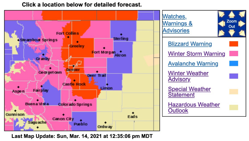
The Winter Storm Warning has been upgraded to a Blizzard Warning for Denver and suburbs west of Denver in Jeffco below 6,000ft. The Winter Storm Warning and Winter Weather Advisory remain in effect
as posted earlier
for everywhere else. There are currently
17 homes without power
according to IREA, estimated restoration is between 12-2pm.
Blizzard Warning
URGENT - WINTER WEATHER MESSAGE
National Weather Service Denver CO
1219 PM MDT Sun Mar 14 2021
...BLIZZARD CONDITIONS WITH DIFFICULT OR IMPOSSIBLE TRAVEL ALONG THE FRONT RANGE THROUGH THIS EVENING...
.Difficult if not impossible travel can be expected across the Front Range and I-25 Corridor through this evening due to blizzard conditions. A significant late season winter storm centered over southeast Colorado will nearly stall today, and then lift slowly northeast and weaken tonight. Significant snow accumulations have already occurred across the Front Range Mountains and Foothills, with a few spots already seeing greater than 2 feet, and well over a foot in the Fort Collins area. Snow will be heavy at times through the day in and near the Front Range and I-25 Corridor. The most severe conditions from deep accumulating snow will likely occur in and near the Front Range Mountains and Foothills where totals of 2 to 4 feet can be expected, and along the I-25 Urban Corridor where 1 to 2 feet will likely fall. The favored locations for the heaviest snow totals along the I-25 Corridor will be from Boulder north through the Fort Collins area. Temperatures will be warm enough to bring a mix of rain and snow across the plains mainly east of a Sterling to Limon line. Winds will gust to between 35 and 45 mph, producing significant blowing and drifting snow and blizzard conditions across the I-25 Corridor.
COZ038>041-043-150230-
/O.UPG.KBOU.WS.W.0004.000000T0000Z-210315T1200Z/
/O.NEW.KBOU.BZ.W.0005.210314T1819Z-210315T0600Z/
Larimer County Below 6000 Feet/Northwest Weld County-
Boulder And Jefferson Counties Below 6000 Feet/West Broomfield County-
North Douglas County Below 6000 Feet/Denver/West Adams and Arapahoe Counties/East Broomfield County-
Elbert/Central and East Douglas Counties Above 6000 Feet-
Central and South Weld County-
Including the cities of Elbert, Roggen,
Arvada, Larkspur, Boulder,
City of Denver, Aurora,
Littleton, Brighton, Highlands Ranch, Fort Lupton, Loveland, Kiowa, Eaton, Longmont, Fondis,
Denver International Airport,
Golden, Parker, Castle Rock,
Lakewood, Fort Collins, Greeley, Nunn, and Hereford
1219 PM MDT Sun Mar 14 2021
...BLIZZARD WARNING IN EFFECT UNTIL MIDNIGHT MDT TONIGHT...
* WHAT...
Blizzard conditions ongoing. Additional snow accumulations of 2 to 6 inches, with storm totals of 14 to 24 inches, heaviest Boulder to Fort Collins corridor. Winds gusting as high as 45 mph.
* WHERE...Fort Collins, Boulder and the
western suburbs of Denver, Denver, Castle Rock, and Greeley.
* WHEN...Until Midnight MDT tonight.
* IMPACTS...
Do not travel. Blowing and drifting snow will significantly reduce visibility with whiteout conditions at times. Scattered power outages can be expected.
PRECAUTIONARY/PREPAREDNESS ACTIONS...
Travel should be restricted to emergencies only. If you must travel, have a winter survival kit with you. If you get stranded, stay with your vehicle. The latest road conditions for Colorado can be obtained by calling 5 1 1 or by going to
www.cotrip.org