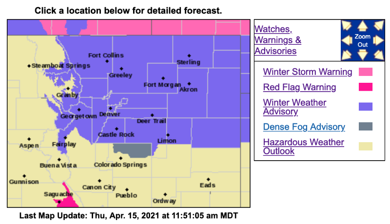
Winter Weather Advisory
URGENT - WINTER WEATHER MESSAGE
National Weather Service Denver CO
1054 AM MDT Thu Apr 15 2021
...SNOW RETURNS TO EASTERN COLORADO...
.A storm system will slowly move across northern Colorado this afternoon and into Friday. Rain may occur initially east of I-25 by mid afternoon, but should change over to snow between 5-7 PM. West of I-25 and across the mountains snow should begin this afternoon and spread east. Travel conditions will deteriorate this evening with the heavier bands of snow, and the Friday morning commute may be also be impacted.
COZ033>035-160100-
/O.CON.KBOU.WW.Y.0024.210415T2100Z-210416T1200Z/
South and East Jackson/Larimer/North and Northeast Grand/Northwest Boulder Counties Above 9000 Feet-
South and Southeast Grand/West Central and Southwest Boulder/Gilpin/
Clear Creek/Summit/North and West Park Counties Above 9000 Feet-
Larimer and Boulder Counties Between 6000 and 9000 Feet-
Including the cities of Glendevey, East Slopes Mosquito Range, Estes Park, Indian Peaks, Nederland, Eisenhower Tunnel, Rocky Mountain National Park,
East Slopes Southern Gore Range, Mount Evans, Laramie and Medicine Bow Mountains, Red Feather Lakes, Cameron Pass,
Breckenridge, Kenosha Mountains, Winter Park, Williams Fork Mountains, Willow Creek Pass, Rabbit Ears Range, and Berthoud Pass
1054 AM MDT Thu Apr 15 2021
...
WINTER WEATHER ADVISORY REMAINS IN EFFECT FROM 3 PM THIS AFTERNOON TO 6 AM MDT FRIDAY...
* WHAT...Snow expected.
Total snow accumulations of 4 to 8 inches.
* WHERE...Rocky Mountain National Park and the Medicine Bow Range, The Mountains of Summit County, the Mosquito Range, and the Indian Peaks, and The Northern Front Range Foothills.
* WHEN...From 3 PM this afternoon to 6 AM MDT Friday.
* IMPACTS...Travel could be very difficult. The hazardous conditions could impact the Thursday evening commute.
PRECAUTIONARY/PREPAREDNESS ACTIONS...
Slow down and use caution while traveling. The latest road conditions for Colorado can be obtained by calling 5 1 1 or by going
to
www.cotrip.org
_ _ _ _ _ _ _ _ _ _ _ _ _ _ _ _ _ _ _ _ _ _ _ _ _ _ _ _ _ _ _ _ _ _ _ _ _ _ _ _ _ _
URGENT - WINTER WEATHER MESSAGE
National Weather Service Denver CO
1054 AM MDT Thu Apr 15 2021
COZ036-038>041-160100-
/O.EXB.KBOU.WW.Y.0024.210415T2100Z-210416T1500Z/
Jefferson and West Douglas Counties Above 6000 Feet/Gilpin/
Clear Creek/Northeast Park Counties Below 9000 Feet-
Larimer County Below 6000 Feet/Northwest Weld County-
Boulder And
Jefferson Counties Below 6000 Feet/West Broomfield County-
North Douglas County Below 6000 Feet/Denver/West Adams and Arapahoe Counties/East Broomfield County-
Elbert/Central and East Douglas Counties Above 6000 Feet-
Including the cities of Elbert, Westcreek, Arvada, Central City, Larkspur,
Bailey, Evergreen, Georgetown, City of Denver, Aurora, Littleton, Brighton, Boulder, Highlands Ranch, Loveland, Kiowa, Longmont, Fondis, Denver International Airport,
Golden, Parker, Castle Rock, Lakewood, Fort Collins, Nunn, Idaho Springs, and Hereford
1054 AM MDT Thu Apr 15 2021
...
WINTER WEATHER ADVISORY IN EFFECT FROM 3 PM THIS AFTERNOON TO 9 AM MDT FRIDAY...
* WHAT...Snow expected.
Total snow accumulations of 3 to 6 inches. Winds gusting as high as 35 mph.
* WHERE...The Southern Front Range Foothills, Fort Collins, Boulder and the western suburbs of Denver, Denver, and Castle Rock.
* WHEN...From 3 PM this afternoon to 9 AM MDT Friday.
* IMPACTS...Plan on slippery road conditions. The hazardous conditions could impact the Thursday evening and Friday morning commutes.