- Posts: 9766
- Thank you received: 221
- Forum
- Life Up the Hill
- Scanner & Emergency Info, Weather Forecasts
- Winter Storm Warning & Winter Weather Advisory April 19-20, 2021
Winter Storm Warning & Winter Weather Advisory April 19-20, 2021
- MountainTownAlerts
-
 Topic Author
- Mountain Legend
-

Less
More
18 Apr 2021 15:30 #1
by MountainTownAlerts
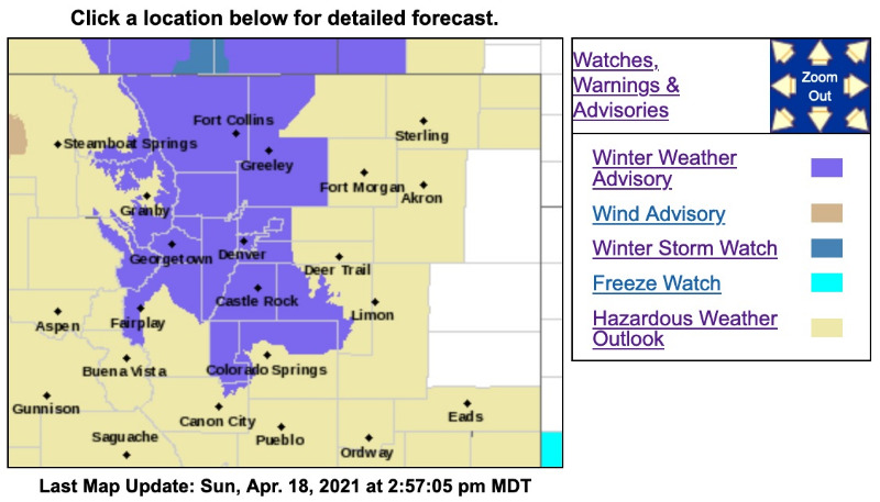
Winter Weather Advisory
URGENT - WINTER WEATHER MESSAGE
National Weather Service Denver CO
156 PM MDT Sun Apr 18 2021
...HEAVY SNOW AND MUCH COLDER TEMPERATURES MOVING IN MONDAY...
.A strong cold front will move across the area Monday morning. Snowfall rates will be up to one inch per hour over the Front Range mountains and foothills, especially Monday afternoon and evening. Temperatures will drop quickly, causing possible flash freeze on roads.
COZ034-036-190800-
/O.NEW.KBOU.WW.Y.0025.210419T1800Z-210420T0900Z/
South and Southeast Grand/West Central and Southwest Boulder/Gilpin/Clear Creek/Summit/North and West Park Counties Above 9000 Feet-
Jefferson and West Douglas Counties Above 6000 Feet/Gilpin/Clear Creek/Northeast Park Counties Below 9000 Feet-
Including the cities of Evergreen, Georgetown, Indian Peaks, Idaho Springs, Eisenhower Tunnel, East Slopes Southern Gore Range, Mount Evans, Central City, East Slopes Mosquito Range, Breckenridge, Winter Park, Williams Fork Mountains, Bailey, Kenosha Mountains, Westcreek, and Berthoud Pass
156 PM MDT Sun Apr 18 2021
...WINTER WEATHER ADVISORY IN EFFECT FROM NOON MONDAY TO 3 AM MDT TUESDAY...
* WHAT...Snow expected. Total snow accumulations of 5 to 10 inches. Winds gusting as high as 35 mph.
* WHERE...The Mountains of Summit County, the Mosquito Range, and the Indian Peaks, and The Southern Front Range Foothills.
* WHEN...From Noon Monday to 3 AM MDT Tuesday.
* IMPACTS...Roads will be icy and snowpacked. The hazardous conditions could impact the Monday evening commute.
PRECAUTIONARY/PREPAREDNESS ACTIONS...
Slow down and use caution while traveling. The latest road conditions for Colorado can be obtained by calling 5 1 1 or by going to www.cotrip.org
_ _ _ _ _ _ _ _ _ _ _ _ _ _ _ _ _ _ _ _ _ _ _ _ _ _ _ _ _ _ _ _ _ _ _ _ _ _ _ _ _ _ _ _ _ _ _ _ _ _ _ _
URGENT - WINTER WEATHER MESSAGE
National Weather Service Denver CO
156 PM MDT Sun Apr 18 2021
...HEAVY SNOW AND MUCH COLDER TEMPERATURES MOVING IN MONDAY...
.A strong cold front will move across the area Monday morning. Snowfall rates will be up to one inch per hour over the Front Range mountains and foothills, especially Monday afternoon and evening. Temperatures will drop quickly, causing possible flash freeze on roads.
COZ038>041-043-190800-
/O.NEW.KBOU.WW.Y.0025.210419T2100Z-210420T0900Z/
Larimer County Below 6000 Feet/Northwest Weld County-
Boulder And Jefferson Counties Below 6000 Feet/West Broomfield County-
North Douglas County Below 6000 Feet/Denver/West Adams and Arapahoe Counties/East Broomfield County-
Elbert/Central and East Douglas Counties Above 6000 Feet-
Central and South Weld County-
Including the cities of Elbert, Roggen, Arvada, Larkspur, Boulder, City of Denver, Aurora, Littleton, Brighton, Highlands Ranch, Fort Lupton, Loveland, Kiowa, Eaton, Longmont, Fondis, Denver International Airport, Golden, Parker, Castle Rock, Lakewood, Fort Collins, Greeley, Nunn, and Hereford
156 PM MDT Sun Apr 18 2021
...WINTER WEATHER ADVISORY IN EFFECT FROM 3 PM MONDAY TO 3 AM MDT TUESDAY...
* WHAT...Snow expected. Total snow accumulations of 3 to 6 inches.
* WHERE...Fort Collins, Boulder and the western suburbs of Denver, Denver, Castle Rock, and Greeley.
* WHEN...From 3 PM Monday to 3 AM MDT Tuesday.
* IMPACTS...Plan on slippery road conditions. The hazardous conditions could impact the Monday evening commute.
For more information from the National Weather Service, visit weather.gov/bou
Please Log in or Create an account to join the conversation.
- MountainTownAlerts
-
Topic Author
- Mountain Legend
-
Less
More
- Posts: 9766
- Thank you received: 221
19 Apr 2021 07:57 #2
by MountainTownAlerts
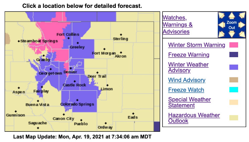
Winter Storm Warning
URGENT - WINTER WEATHER MESSAGE
National Weather Service Denver CO
426 AM MDT Mon Apr 19 2021
...HEAVY SNOW AND MUCH COLDER TEMPERATURES LATER TODAY...
.Snow will develop and become heavy at times from north to south across the Front Range this afternoon, and then continue through the evening. Snowfall rates around one inch per hour can be expected along the I-25 Corridor, and up to 2 inches per hour in the Front Range Foothills. Temperatures will drop quickly, causing a possible flash freeze on roads and very slick/hazardous travel conditions. The evening commute will likely be impacted, especially by 5 pm along the I-25 Corridor, and by 3 pm in the northern foothills.
COZ039-191830-
/O.UPG.KBOU.WW.Y.0025.210419T2100Z-210420T0900Z/
/O.NEW.KBOU.WS.W.0006.210419T2100Z-210420T0900Z/
Boulder And Jefferson Counties Below 6000 Feet/West Broomfield County-
Including the cities of Boulder, Golden, Longmont, Arvada, and Lakewood
426 AM MDT Mon Apr 19 2021
...WINTER STORM WARNING IN EFFECT FROM 3 PM THIS AFTERNOON TO 3 AM MDT TUESDAY...
* WHAT...Snow expected. Total snow accumulations of 5 to 8 inches, most of it within 6 to 9 hours, with locally heavier amounts near the base of the foothills.
* WHERE...Boulder and the western suburbs of Denver.
* WHEN...From 3 PM this afternoon to 3 AM MDT Tuesday.
* IMPACTS...Travel could be very difficult. The hazardous conditions could impact the Monday evening commute.
PRECAUTIONARY/PREPAREDNESS ACTIONS...
If you must travel, keep an extra flashlight, food, and water in your vehicle in case of an emergency. The latest road conditions for Colorado can be obtained by calling 5 1 1 or by going to www.cotrip .
_ _ _ _ _ _ _ _ _ _ _ _ _ _ _ _ _ _ _ _ _ _ _ _ _ _ _ _ _ _ _ _ _ _ _ _ _ _ _ _ _ _ _ _ _ _ _ _
Winter Weather Advisory
URGENT - WINTER WEATHER MESSAGE
National Weather Service Denver CO
426 AM MDT Mon Apr 19 2021
COZ034-036-191830-
/O.CON.KBOU.WW.Y.0025.210419T1800Z-210420T0900Z/
South and Southeast Grand/West Central and Southwest Boulder/Gilpin/Clear Creek/Summit/North and West Park Counties Above 9000 Feet-
Jefferson and West Douglas Counties Above 6000 Feet/Gilpin/Clear Creek/Northeast Park Counties Below 9000 Feet-
Including the cities of Evergreen, Georgetown, Indian Peaks, Idaho Springs, Eisenhower Tunnel, East Slopes Southern Gore Range, Mount Evans, Central City, East Slopes Mosquito Range, Breckenridge, Winter Park, Williams Fork Mountains, Bailey, Kenosha Mountains, Westcreek, and Berthoud Pass
426 AM MDT Mon Apr 19 2021
...WINTER WEATHER ADVISORY REMAINS IN EFFECT FROM NOON TODAY TO 3 AM MDT TUESDAY...
* WHAT...Snow expected. Total snow accumulations of 6 to 12 inches along and north of I-70, 4 to 7 inches to the south. Lighter snow accumulations of 1 to 4 inches west of the Eisenhower Tunnel. Winds gusting as high as 35 mph.
* WHERE...The Mountains of Summit County, the Mosquito Range, and the Indian Peaks, and The Southern Front Range Foothills.
* WHEN...From Noon today to 3 AM MDT Tuesday.
* IMPACTS...Travel could be very difficult. The hazardous conditions could impact the Monday evening commute.
Replied by MountainTownAlerts on topic Winter Storm Warning & Winter Weather Advisory April 19-20, 2021
Winter Storm Warning
URGENT - WINTER WEATHER MESSAGE
National Weather Service Denver CO
426 AM MDT Mon Apr 19 2021
...HEAVY SNOW AND MUCH COLDER TEMPERATURES LATER TODAY...
.Snow will develop and become heavy at times from north to south across the Front Range this afternoon, and then continue through the evening. Snowfall rates around one inch per hour can be expected along the I-25 Corridor, and up to 2 inches per hour in the Front Range Foothills. Temperatures will drop quickly, causing a possible flash freeze on roads and very slick/hazardous travel conditions. The evening commute will likely be impacted, especially by 5 pm along the I-25 Corridor, and by 3 pm in the northern foothills.
COZ039-191830-
/O.UPG.KBOU.WW.Y.0025.210419T2100Z-210420T0900Z/
/O.NEW.KBOU.WS.W.0006.210419T2100Z-210420T0900Z/
Boulder And Jefferson Counties Below 6000 Feet/West Broomfield County-
Including the cities of Boulder, Golden, Longmont, Arvada, and Lakewood
426 AM MDT Mon Apr 19 2021
...WINTER STORM WARNING IN EFFECT FROM 3 PM THIS AFTERNOON TO 3 AM MDT TUESDAY...
* WHAT...Snow expected. Total snow accumulations of 5 to 8 inches, most of it within 6 to 9 hours, with locally heavier amounts near the base of the foothills.
* WHERE...Boulder and the western suburbs of Denver.
* WHEN...From 3 PM this afternoon to 3 AM MDT Tuesday.
* IMPACTS...Travel could be very difficult. The hazardous conditions could impact the Monday evening commute.
PRECAUTIONARY/PREPAREDNESS ACTIONS...
If you must travel, keep an extra flashlight, food, and water in your vehicle in case of an emergency. The latest road conditions for Colorado can be obtained by calling 5 1 1 or by going to www.cotrip .
_ _ _ _ _ _ _ _ _ _ _ _ _ _ _ _ _ _ _ _ _ _ _ _ _ _ _ _ _ _ _ _ _ _ _ _ _ _ _ _ _ _ _ _ _ _ _ _
Winter Weather Advisory
URGENT - WINTER WEATHER MESSAGE
National Weather Service Denver CO
426 AM MDT Mon Apr 19 2021
COZ034-036-191830-
/O.CON.KBOU.WW.Y.0025.210419T1800Z-210420T0900Z/
South and Southeast Grand/West Central and Southwest Boulder/Gilpin/Clear Creek/Summit/North and West Park Counties Above 9000 Feet-
Jefferson and West Douglas Counties Above 6000 Feet/Gilpin/Clear Creek/Northeast Park Counties Below 9000 Feet-
Including the cities of Evergreen, Georgetown, Indian Peaks, Idaho Springs, Eisenhower Tunnel, East Slopes Southern Gore Range, Mount Evans, Central City, East Slopes Mosquito Range, Breckenridge, Winter Park, Williams Fork Mountains, Bailey, Kenosha Mountains, Westcreek, and Berthoud Pass
426 AM MDT Mon Apr 19 2021
...WINTER WEATHER ADVISORY REMAINS IN EFFECT FROM NOON TODAY TO 3 AM MDT TUESDAY...
* WHAT...Snow expected. Total snow accumulations of 6 to 12 inches along and north of I-70, 4 to 7 inches to the south. Lighter snow accumulations of 1 to 4 inches west of the Eisenhower Tunnel. Winds gusting as high as 35 mph.
* WHERE...The Mountains of Summit County, the Mosquito Range, and the Indian Peaks, and The Southern Front Range Foothills.
* WHEN...From Noon today to 3 AM MDT Tuesday.
* IMPACTS...Travel could be very difficult. The hazardous conditions could impact the Monday evening commute.
Please Log in or Create an account to join the conversation.
- Forum
- Life Up the Hill
- Scanner & Emergency Info, Weather Forecasts
- Winter Storm Warning & Winter Weather Advisory April 19-20, 2021
Time to create page: 0.178 seconds
sponsors


