- Posts: 9766
- Thank you received: 221
- Forum
- Life Up the Hill
- Scanner & Emergency Info, Weather Forecasts
- Winter Storm Watch April 27-28, 2021
Winter Storm Watch April 27-28, 2021
- MountainTownAlerts
-
 Topic Author
- Mountain Legend
-

Less
More
26 Apr 2021 15:47 #1
by MountainTownAlerts
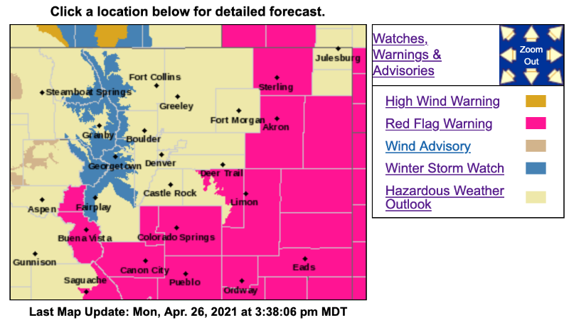
Winter Storm Watch
URGENT - WINTER WEATHER MESSAGE
National Weather Service Denver CO
310 PM MDT Mon Apr 26 2021
COZ033-034-271100-
/O.NEW.KBOU.WS.A.0004.210427T1800Z-210428T1800Z/
South and East Jackson/Larimer/North and Northeast Grand/Northwest Boulder Counties Above 9000 Feet-
South and Southeast Grand/West Central and Southwest Boulder/Gilpin/Clear Creek/Summit/North and West Park Counties Above 9000 Feet-
Including the cities of East Slopes Mosquito Range, Indian Peaks, Eisenhower Tunnel, Rocky Mountain National Park, East Slopes Southern Gore Range, Mount Evans, Laramie and Medicine Bow Mountains, Cameron Pass, Breckenridge, Kenosha Mountains, Winter Park, Williams Fork Mountains, Willow Creek Pass, Rabbit Ears Range, and Berthoud Pass
310 PM MDT Mon Apr 26 2021
...WINTER STORM WATCH IN EFFECT FROM TUESDAY AFTERNOON THROUGH WEDNESDAY MORNING FOR THE FRONT RANGE MOUNTAINS ABOVE 9000 FEET...
* WHAT...Heavy snow possible. Total snow accumulations of 6 to 14 inches possible.
* WHERE...Rocky Mountain National Park and the Medicine Bow Range, and The Mountains of Summit County, the Mosquito Range, and the Indian Peaks.
* WHEN...From Tuesday afternoon through Wednesday morning.
* IMPACTS...Travel could be difficult with slushy roads and low visibilities due to heavy snowfall. The main impacts will be on the east slopes from Interstate 70 northward.
PRECAUTIONARY/PREPAREDNESS ACTIONS...
Monitor the latest forecasts for updates on this situation.
&&
$$
For more information from the National Weather Service, visit weather.gov/bou
Winter Storm Watch April 27-28, 2021 was created by MountainTownAlerts
Winter Storm Watch
URGENT - WINTER WEATHER MESSAGE
National Weather Service Denver CO
310 PM MDT Mon Apr 26 2021
COZ033-034-271100-
/O.NEW.KBOU.WS.A.0004.210427T1800Z-210428T1800Z/
South and East Jackson/Larimer/North and Northeast Grand/Northwest Boulder Counties Above 9000 Feet-
South and Southeast Grand/West Central and Southwest Boulder/Gilpin/Clear Creek/Summit/North and West Park Counties Above 9000 Feet-
Including the cities of East Slopes Mosquito Range, Indian Peaks, Eisenhower Tunnel, Rocky Mountain National Park, East Slopes Southern Gore Range, Mount Evans, Laramie and Medicine Bow Mountains, Cameron Pass, Breckenridge, Kenosha Mountains, Winter Park, Williams Fork Mountains, Willow Creek Pass, Rabbit Ears Range, and Berthoud Pass
310 PM MDT Mon Apr 26 2021
...WINTER STORM WATCH IN EFFECT FROM TUESDAY AFTERNOON THROUGH WEDNESDAY MORNING FOR THE FRONT RANGE MOUNTAINS ABOVE 9000 FEET...
* WHAT...Heavy snow possible. Total snow accumulations of 6 to 14 inches possible.
* WHERE...Rocky Mountain National Park and the Medicine Bow Range, and The Mountains of Summit County, the Mosquito Range, and the Indian Peaks.
* WHEN...From Tuesday afternoon through Wednesday morning.
* IMPACTS...Travel could be difficult with slushy roads and low visibilities due to heavy snowfall. The main impacts will be on the east slopes from Interstate 70 northward.
PRECAUTIONARY/PREPAREDNESS ACTIONS...
Monitor the latest forecasts for updates on this situation.
&&
$$
For more information from the National Weather Service, visit weather.gov/bou
Please Log in or Create an account to join the conversation.
- MountainTownAlerts
-
Topic Author
- Mountain Legend
-
Less
More
- Posts: 9766
- Thank you received: 221
27 Apr 2021 08:18 #2
by MountainTownAlerts
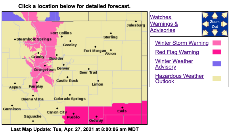
Winter Storm Warning
URGENT - WINTER WEATHER MESSAGE
National Weather Service Denver CO
316 AM MDT Tue Apr 27 2021
COZ033-034-272130-
/O.UPG.KBOU.WS.A.0004.210427T1800Z-210428T1800Z/
/O.NEW.KBOU.WS.W.0007.210427T1800Z-210428T1800Z/
South and East Jackson/Larimer/North and Northeast Grand/Northwest Boulder Counties Above 9000 Feet-
South and Southeast Grand/West Central and Southwest Boulder/Gilpin/Clear Creek/Summit/North and West Park Counties Above 9000 Feet-
Including the cities of East Slopes Mosquito Range, Indian Peaks, Eisenhower Tunnel, Rocky Mountain National Park, East Slopes Southern Gore Range, Mount Evans, Laramie and Medicine Bow Mountains, Cameron Pass, Breckenridge, Kenosha Mountains, Winter Park, Williams Fork Mountains, Willow Creek Pass, Rabbit Ears Range, and Berthoud Pass
316 AM MDT Tue Apr 27 2021
...WINTER STORM WARNING IN EFFECT FROM NOON TODAY TO NOON MDT WEDNESDAY FRONT RANGE MOUNTAINS ABOVE 9000 FEET...
* WHAT...Heavy snow possible. Total snow accumulations of 7 to 14 inches possible.
* WHERE...Rocky Mountain National Park and the Medicine Bow Range, and The Mountains of Summit County, the Mosquito Range, and the Indian Peaks.
* WHEN...From Noon today to Noon MDT Wednesday.
* IMPACTS...Roads will likely become slick and hazardous. Travel could be very difficult. The hazardous conditions could impact the Tuesday evening and Wednesday morning commutes.
PRECAUTIONARY/PREPAREDNESS ACTIONS...
Roads will be slick resulting in slow and hazardous travel. Allow extra time to reach your destination. The latest road conditions for Colorado can be obtained by calling 5 1 1 or by going to www.cotrip.org
_ _ _ _ _ _ _ _ _ _ _ _ _ _ _ _ _ _ _ _ _ _ _ _ _ _ _ _ _ _ _ _ _ _ _
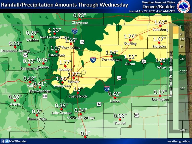
Rain showers and scattered thunderstorms will develop late this morning and early afternoon with rain continuing tonight and possibly into Wednesday. Widespread 1 to 2 inches of rain is expected. Locally up to 3 inches of rain will be possible, and may result in ponding in ditches and low lying areas.
Replied by MountainTownAlerts on topic Winter Storm Watch April 27-28, 2021
Winter Storm Warning
URGENT - WINTER WEATHER MESSAGE
National Weather Service Denver CO
316 AM MDT Tue Apr 27 2021
COZ033-034-272130-
/O.UPG.KBOU.WS.A.0004.210427T1800Z-210428T1800Z/
/O.NEW.KBOU.WS.W.0007.210427T1800Z-210428T1800Z/
South and East Jackson/Larimer/North and Northeast Grand/Northwest Boulder Counties Above 9000 Feet-
South and Southeast Grand/West Central and Southwest Boulder/Gilpin/Clear Creek/Summit/North and West Park Counties Above 9000 Feet-
Including the cities of East Slopes Mosquito Range, Indian Peaks, Eisenhower Tunnel, Rocky Mountain National Park, East Slopes Southern Gore Range, Mount Evans, Laramie and Medicine Bow Mountains, Cameron Pass, Breckenridge, Kenosha Mountains, Winter Park, Williams Fork Mountains, Willow Creek Pass, Rabbit Ears Range, and Berthoud Pass
316 AM MDT Tue Apr 27 2021
...WINTER STORM WARNING IN EFFECT FROM NOON TODAY TO NOON MDT WEDNESDAY FRONT RANGE MOUNTAINS ABOVE 9000 FEET...
* WHAT...Heavy snow possible. Total snow accumulations of 7 to 14 inches possible.
* WHERE...Rocky Mountain National Park and the Medicine Bow Range, and The Mountains of Summit County, the Mosquito Range, and the Indian Peaks.
* WHEN...From Noon today to Noon MDT Wednesday.
* IMPACTS...Roads will likely become slick and hazardous. Travel could be very difficult. The hazardous conditions could impact the Tuesday evening and Wednesday morning commutes.
PRECAUTIONARY/PREPAREDNESS ACTIONS...
Roads will be slick resulting in slow and hazardous travel. Allow extra time to reach your destination. The latest road conditions for Colorado can be obtained by calling 5 1 1 or by going to www.cotrip.org
_ _ _ _ _ _ _ _ _ _ _ _ _ _ _ _ _ _ _ _ _ _ _ _ _ _ _ _ _ _ _ _ _ _ _
Rain showers and scattered thunderstorms will develop late this morning and early afternoon with rain continuing tonight and possibly into Wednesday. Widespread 1 to 2 inches of rain is expected. Locally up to 3 inches of rain will be possible, and may result in ponding in ditches and low lying areas.
Please Log in or Create an account to join the conversation.
- MountainTownAlerts
-
Topic Author
- Mountain Legend
-
Less
More
- Posts: 9766
- Thank you received: 221
27 Apr 2021 19:52 #3
by MountainTownAlerts
Replied by MountainTownAlerts on topic Winter Storm Watch April 27-28, 2021
From Chief Meteorologist Steve Hamilton:
Update: My Mountain Town Weather...
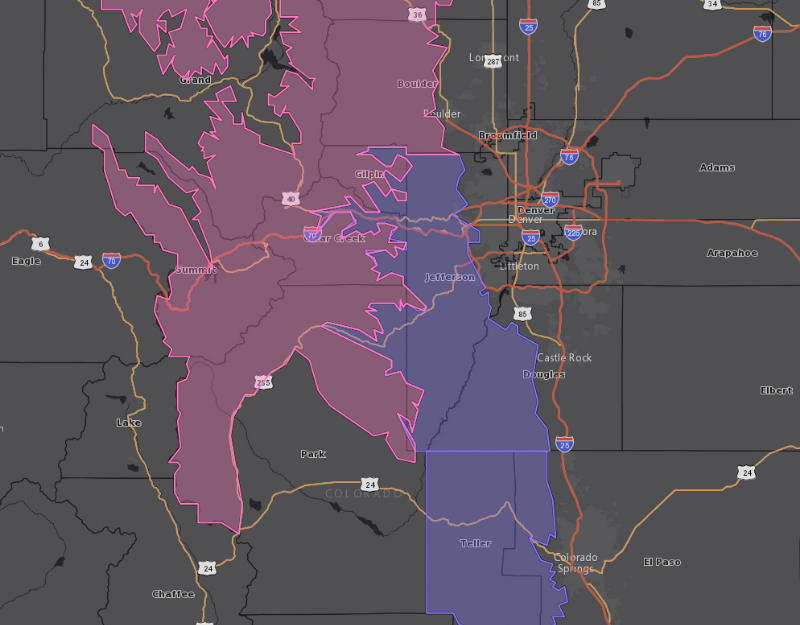
Winter Weather Advisory - Purple on map
Winter Storm Warning - Pink on map
Here's the deal on this interesting spring storm we have going on. The National Weather Service has issued a Winter Weather Advisory until Noon Wednesday.
Keep in mind, with most of the Foothills expected to get a rain/snow mix, with occasional rounds of all-snow, and also banding snow, and heavy snow showers, predictions on totals are going to be very difficult. As much as 14 inches will fall in some areas like Conifer, Fairplay, Alma and Como. Lesser amounts are likely elsewhere, although some spots could get significant snow in the 3 to 10 inch range.
The best snowfall potential will be tonight into early tomorrow, above 7,500 feet, with mostly a rain/snow mix elsewhere. Nature talks, and we listen. Just take it easy on the roads and be prepared for potentially heavy snowfall.
Forecast Summary:
The Winter Storm Warnings and Winter Weather Advisories will expire around Noon on Wednesday. The low pressure system over the Southern Plains will be moving east, and high pressure will enter our area from the west. That will clear things up in the Foothills during the afternoon and evening. With the temperature variations, precipitation will range from snow, to a rain/snow mix, or all rain. However, all precipitation will be ending by Wednesday afternoon. High pressure moves in Wednesday night, with chilly temperatures. Then, Thursday and Friday look fair, with a warming trend into the weekend.
Details: mymountaintown.com/expert-local-weather
Update: My Mountain Town Weather...
Winter Weather Advisory - Purple on map
Winter Storm Warning - Pink on map
Here's the deal on this interesting spring storm we have going on. The National Weather Service has issued a Winter Weather Advisory until Noon Wednesday.
Keep in mind, with most of the Foothills expected to get a rain/snow mix, with occasional rounds of all-snow, and also banding snow, and heavy snow showers, predictions on totals are going to be very difficult. As much as 14 inches will fall in some areas like Conifer, Fairplay, Alma and Como. Lesser amounts are likely elsewhere, although some spots could get significant snow in the 3 to 10 inch range.
The best snowfall potential will be tonight into early tomorrow, above 7,500 feet, with mostly a rain/snow mix elsewhere. Nature talks, and we listen. Just take it easy on the roads and be prepared for potentially heavy snowfall.
Forecast Summary:
The Winter Storm Warnings and Winter Weather Advisories will expire around Noon on Wednesday. The low pressure system over the Southern Plains will be moving east, and high pressure will enter our area from the west. That will clear things up in the Foothills during the afternoon and evening. With the temperature variations, precipitation will range from snow, to a rain/snow mix, or all rain. However, all precipitation will be ending by Wednesday afternoon. High pressure moves in Wednesday night, with chilly temperatures. Then, Thursday and Friday look fair, with a warming trend into the weekend.
Details: mymountaintown.com/expert-local-weather
Please Log in or Create an account to join the conversation.
- Forum
- Life Up the Hill
- Scanner & Emergency Info, Weather Forecasts
- Winter Storm Watch April 27-28, 2021
Time to create page: 0.192 seconds
sponsors


