Flash Flood Watch
Flood Watch
National Weather Service Denver CO
945 AM MDT Fri Jul 30 2021
COZ036>041-043-302345-
/O.EXB.KBOU.FF.A.0007.210731T0000Z-210801T0300Z/
/00000.0.ER.000000T0000Z.000000T0000Z.000000T0000Z.OO/
Jefferson and West Douglas Counties Above 6000 Feet/Gilpin/Clear Creek/Northeast Park Counties Below 9000 Feet-
Central and Southeast Park County-Larimer County Below 6000 Feet/Northwest Weld County-
Boulder And Jefferson Counties Below 6000 Feet/West Broomfield County-
North Douglas County Below 6000 Feet/Denver/West Adams and Arapahoe Counties/East Broomfield County-
Elbert/Central and East Douglas Counties Above 6000 Feet-
Central and South Weld County-
Including the cities of Hartsel, Elbert, Westcreek, Roggen,
Arvada, Central City, Larkspur,
Bailey, Evergreen, Georgetown, Lakewood, Aurora,
Fairplay, Littleton, Brighton, Boulder, Highlands Ranch, Fort Lupton, Loveland, Kiowa, Eaton, Longmont, Fondis,
Denver International Airport, Golden, Parker, Castle Rock, City of Denver, Fort Collins, Greeley, Nunn,
Idaho Springs, Lake George, Hereford, and
South Park
945 AM MDT Fri Jul 30 2021
...
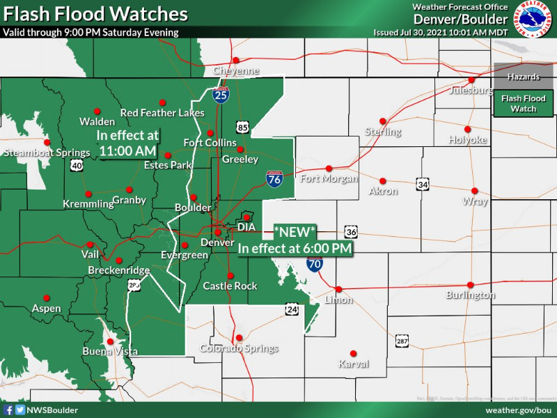
FLASH FLOOD WATCH IN EFFECT FROM 6 PM MDT THIS EVENING UNTIL 9 PM SATURDAY EVENING...
The National Weather Service in Denver has expanded the
* Flash Flood Watch to include Portions of central, north central, and northeast Colorado, including the following areas, in central Colorado, Central and Southeast Park County and Jefferson and West Douglas Counties Above 6000 Feet/Gilpin/Clear Creek/Northeast Park Counties Below 9000 Feet. In north central Colorado, Larimer County Below 6000 Feet/Northwest Weld County. In northeast Colorado, Boulder And Jefferson Counties Below 6000 Feet/West Broomfield County, Central and South Weld County, Elbert/Central and East Douglas Counties Above 6000 Feet and North Douglas County Below 6000 Feet/Denver/West Adams and Arapahoe Counties/East Broomfield County.
* From 6 PM MDT this evening through Saturday evening.
* Scattered thunderstorms will develop late this afternoon or evening, and may then continue overnight with locally heavy rainfall and potential for flash flooding. Rainfall amounts of 1 to 2 inches in less than an hour will be possible from the stronger storms. There is a threat that a few storms with heavy rain will continue overnight into early Saturday morning. Additional rounds of showers and storms can be expected Saturday afternoon and evening.
* Flash flooding will be possible in urban and low lying areas.
PRECAUTIONARY/PREPAREDNESS ACTIONS...
You should monitor later forecasts and be prepared to take action should Flash Flood Warnings be issued. Never drive through a flooded area.
_ _ _ _ _ _ _
Flood Watch
National Weather Service Denver CO
945 AM MDT Fri Jul 30 2021
COZ030>035-302345-
/O.EXT.KBOU.FF.A.0007.210730T1700Z-210801T0300Z/
/00000.0.ER.000000T0000Z.000000T0000Z.000000T0000Z.OO/
Jackson County Below 9000 Feet-
West Jackson and West Grand Counties Above 9000 Feet-
Grand and Summit Counties Below 9000 Feet-
South and East Jackson/Larimer/North and Northeast Grand/Northwest Boulder Counties Above 9000 Feet-
South and Southeast Grand/West Central and Southwest Boulder/Gilpin/
Clear Creek/Summit/North and West Park Counties Above 9000 Feet-
Larimer and Boulder Counties Between 6000 and 9000 Feet-
Including the cities of North Park, Rocky Mountain National Park, Mt Zirkel, Laramie and Medicine Bow Mountains, Red Feather Lakes,
Breckenridge, Williams Fork Mountains, Glendevey, Indian Peaks, Nederland, Eisenhower Tunnel, Kremmling,
East Slopes Southern Gore Range, Mount Evans, Grand Lake, Cameron Pass,
East Slopes Mosquito Range, Berthoud Pass, Winter Park, Granby, Hot Sulphur Springs, Kenosha Mountains, Gould, Willow Creek Pass, Spicer, Rand, Estes Park, Dillon, Fraser, Walden, and Rabbit Ears Range
945 AM MDT Fri Jul 30 2021
...
FLASH FLOOD WATCH NOW IN EFFECT UNTIL 9 PM SATURDAY EVENING...
The Flash Flood Watch is now in effect for
* Portions of central and north central Colorado, including the following areas, in central Colorado, Grand and Summit Counties Below 9000 Feet and South and Southeast Grand/West Central and Southwest Boulder/Gilpin/Clear Creek/Summit/North and West Park Counties Above 9000 Feet. In north central Colorado, Jackson County Below 9000 Feet, Larimer and Boulder Counties Between 6000 and 9000 Feet, South and East Jackson/Larimer/North and Northeast Grand/Northwest Boulder Counties Above 9000 Feet and West Jackson and West Grand Counties Above 9000 Feet.
* Through Saturday evening.
* Thunderstorms will become more numerous across the mountains and foothills by this afternoon, and will have potential to produce flash flooding. The highest threat areas would be the Cameron Peak, East Troublesome, Williams Fork, and Calwood burn areas, but flash flooding will even be possible in non-burn scar areas due to the intensity of the rainfall. Rainfall amounts around 1.5 inches will be possible in less than an hour. While storms should gradually diminish overnight, there is still a threat of heavy rain continuing in the foothill areas overnight into early Saturday morning. Additional rounds of showers and storms can be expected Saturday afternoon and evening.
* Burn scars will be particularly susceptible to heavy rainfall, leading to quick runoff and debris and mud flows. The flood threat may last through the night.
PRECAUTIONARY/PREPAREDNESS ACTIONS...
Have multiple ways to receive warnings, including television, weather radio, phone, family, and friends. Avoid burn areas in particular, and be ready to move to higher ground.