Some Snow Through Thursday Night... Nice Weekend Coming Up...
An area of low pressure will move across Colorado on Thursday and Thursday night. This system isn't particularly strong, but with colder air coming in from the west, we'll have the potential for some accumulating snowfall for most of the foothills. The best chance for snow will be Thursday afternoon into the mid-evening hours. Along with the snow will come breezy to gusty conditions.
As for accumulation, about the most we'll see is 3" anywhere across our area. Conifer, Alma and Fairplay could get about 3", with maybe 2" in Evergreen, and 1-2" elsewhere. The wind will make for hazardous travel Thursday afternoon and evening, and roads will likely be slick. High pressure moves in on Friday, with a fair and mild weekend ahead.
Details for each of our mountain towns:
mymountaintown.com/expert-local-weather
-Chief Meteorologist Steve Hamilton
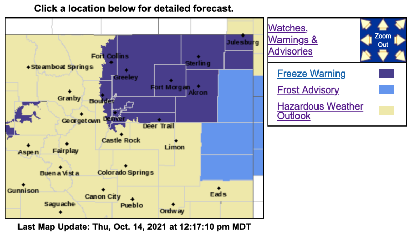
Freeze Warning
URGENT - WEATHER MESSAGE
National Weather Service Denver CO
755 AM MDT Thu Oct 14 2021
COZ038>040-042>045-048>051-150400-
/O.CAN.KBOU.FR.Y.0003.000000T0000Z-211014T1500Z/
/O.CON.KBOU.FZ.W.0003.211015T0600Z-211015T1500Z/
Larimer County Below 6000 Feet/Northwest Weld County-
Boulder And Jefferson Counties Below 6000 Feet/West Broomfield County-North Douglas County Below 6000 Feet/Denver/West Adams and Arapahoe Counties/East Broomfield County-Northeast Weld County-Central and South Weld County-Morgan County-Central and East Adams and Arapahoe Counties-Logan County-Washington County-Sedgwick County-Phillips County-
Including the cities of Wiggins, Pawnee Buttes, Roggen,
Arvada, Byers, Julesburg, Briggsdale, Leader, Boulder, Fort Morgan,
City of Denver, Cope, Aurora, Littleton, Amherst, Akron, Last Chance, Raymer, Brighton, Sterling, Highlands Ranch, Fort Lupton, Ovid, Loveland, Peetz, Grover, Eaton, Deer Trail, Longmont, Sedgwick, Denver International Airport, Haxtun, Goodrich,
Golden, Parker,
Lakewood, Stoneham, Fort Collins, Greeley, Bennett, Otis, Crook, Holyoke, Nunn, Brush, Hereford, and Merino
755 AM MDT Thu Oct 14 2021
...
FREEZE WARNING REMAINS IN EFFECT FROM MIDNIGHT TONIGHT TO 9 AM MDT FRIDAY...
...FROST ADVISORY FOR THIS MORNING IS CANCELLED...
* WHAT...A Freeze is expected tonight with lows in the upper 20s.
* WHERE...Portions of north central and northeast Colorado.
* WHEN...From Midnight tonight to 9 AM MDT Friday.
* IMPACTS...Frost and freeze conditions could kill crops, other sensitive vegetation and possibly damage unprotected outdoor plumbing.
PRECAUTIONARY/PREPAREDNESS ACTIONS...
Take steps now to protect tender plants from the cold.
For more information from the National Weather Service, visit
weather.gov/bou