URGENT from Chief Meteorologist Steve Hamilton: High Wind Warning For Parts Of The Foothills...
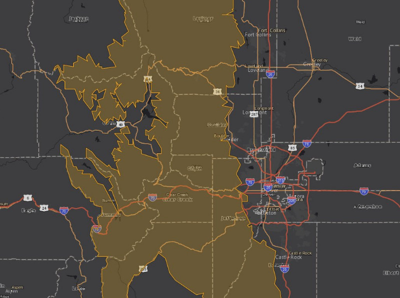
The National Weather Service in Boulder has issued a High Wind Warning (amber highlighted area on map below) from 11:00 p.m. Saturday until 11:00 a.m. Sunday. Wind gusts of 25 to 40 mph are likely, with a few gusts up to 80 mph possible in wind-prone areas. Damage to trees and power lines is possible. Travel may be difficult for high-profile vehicles.
High Wind Warning
URGENT - WEATHER MESSAGE
National Weather Service Denver CO
241 PM MST Sat Dec 4 2021
COZ033>036-050945-
/O.UPG.KBOU.HW.A.0006.211205T0900Z-211205T1800Z/
/O.NEW.KBOU.HW.W.0008.211205T0600Z-211205T1800Z/
South and East Jackson/Larimer/North and Northeast Grand/Northwest Boulder Counties Above 9000 Feet-South and Southeast Grand/West Central and Southwest Boulder/Gilpin/Clear Creek/Summit/North and West Park Counties Above 9000 Feet-Larimer and Boulder Counties Between 6000 and 9000 Feet-Jefferson and West Douglas Counties Above 6000 Feet/Gilpin/Clear Creek/Northeast Park Counties Below 9000 Feet-
Including the cities of Winter Park, Westcreek, Rocky Mountain National Park, Central City, Red Feather Lakes,
Breckenridge, Bailey, Williams Fork Mountains, Evergreen, Georgetown, Glendevey, Indian Peaks, Nederland,
Eisenhower Tunnel, East Slopes Southern Gore Range, Mount Evans, Cameron Pass,
East Slopes Mosquito Range, Berthoud Pass, Kenosha Mountains, Estes Park, Willow Creek Pass, Laramie and Medicine Bow Mountains,
Idaho Springs, and Rabbit Ears Range
241 PM MST Sat Dec 4 2021
...
HIGH WIND WARNING IN EFFECT FROM 11 PM THIS EVENING TO 11 AM MST SUNDAY...
* WHAT...West winds 25 to 40 mph with gusts up to 80 mph possible.
* WHERE...
Jefferson and West Douglas Counties Above 6000 Feet/Gilpin/Clear Creek/Northeast Park Counties Below 9000 Feet, South and Southeast Grand/West Central and Southwest Boulder/Gilpin/
Clear Creek/Summit/North and West Park Counties Above 9000 Feet, Larimer and Boulder Counties Between 6000 and 9000 Feet and South and East Jackson/Larimer/North and Northeast Grand/Northwest Boulder Counties Above 9000 Feet Counties.
* WHEN...From 11 PM this evening to 11 AM MST Sunday.
* IMPACTS...Damaging winds may blow down trees and power lines. Power outages are possible. Gusty winds will blow around unsecured objects and a few power outages may result.
PRECAUTIONARY/PREPAREDNESS ACTIONS...
Winds this strong can make driving difficult, especially for high profile vehicles. Use extra caution.
For more information from the National Weather Service, visit
weather.gov/bou