From Chief Meteorologist Steve Hamilton:
Snow Thursday Night Into Friday? It's possible...
We'll have some moderation on our daytime highs for most of the Foothills on Tuesday. The exceptions will be around the Fairplay area, where we'll stay in the 30s. High pressure will gradually strengthen over the Central Rockies on Wednesday, resulting in very gusty wind for most areas. Some of the more wind-prone areas could have gusts in the 40-45 mph range. Then things start to get interesting on Thursday. We're tracking a low pressure trough coming into the Pacific Northwest. That should drop southward and cut across Colorado late Thursday and into Friday. It's looking like we may have enough moist air available for isolated to scattered rain/snow showers beginning Thursday afternoon. Our best precipitation chances will be late Thursday night into Friday. This is a fairly fast-moving system, so snow accumulation should be light, but a little is better than none. This could also mean the first measurable snowfall for the Denver Metro this season.
Check back to his weather page for updates:
mymountaintown.com/expert-local-weather
From US National Weather Service Denver/Boulder:
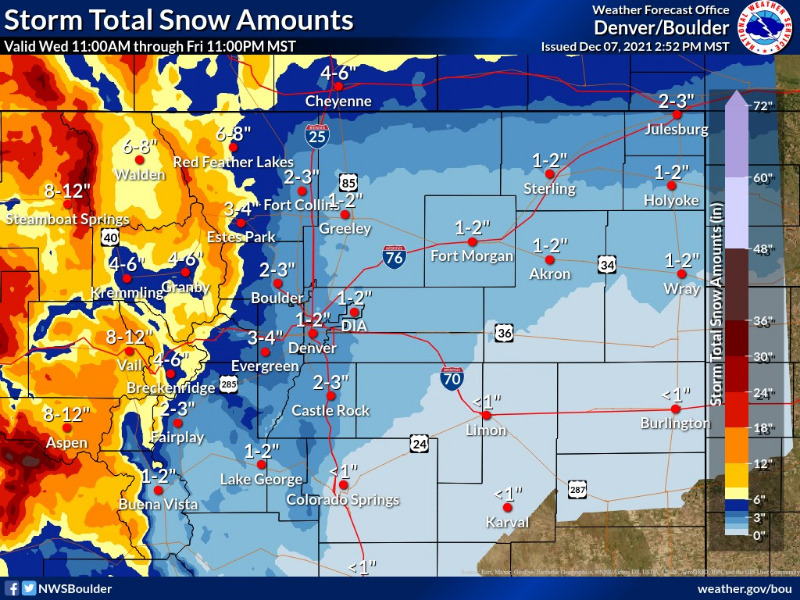
It's been a long time since we can say this but we finally have accumulating snow for the majority of Colorado in the forecast! It won't be much across the I-25 corridor and plains but it appears likely that our snowless streak will come to an end in Denver.
Hazardous Weather Outlook
Hazardous Weather Outlook
National Weather Service Denver/Boulder CO
1055 AM MST Tue Dec 7 2021
COZ030>051-081800-
Jackson County Below 9000 Feet-
West Jackson and West Grand Counties Above 9000 Feet-
Grand and Summit Counties Below 9000 Feet-
South and East Jackson/Larimer/North and Northeast Grand/Northwest Boulder Counties Above 9000 Feet-
South and Southeast Grand/West Central and Southwest Boulder/Gilpin/
Clear Creek/Summit/North and West Park Counties Above9000 Feet-
Larimer and Boulder Counties Between 6000 and 9000 Feet-
Jefferson and West Douglas Counties Above 6000 Feet/Gilpin/Clear Creek/Northeast Park Counties Below 9000 Feet-
Central and Southeast Park County-
Larimer County Below 6000 Feet/Northwest Weld County-
Boulder And Jefferson Counties Below 6000 Feet/West Broomfield County-
North Douglas County Below 6000 Feet/Denver/West Adams and Arapahoe Counties/East Broomfield County-
Elbert/Central and East Douglas Counties Above 6000 Feet-
Northeast Weld County-
Central and South Weld County-Morgan County-
Central and East Adams and Arapahoe Counties-
North and Northeast Elbert County Below 6000 Feet/North Lincoln County-
Southeast Elbert County Below 6000 Feet/South Lincoln County-
Logan County-Washington County-Sedgwick County-Phillips County-
1055 AM MST Tue Dec 7 2021
This hazardous weather outlook is for northeast and north central Colorado.
.DAY ONE...Today and Tonight
Light snow and flurries should linger into the afternoon over isolated parts of the mountains. No additional accumulation or impacts are expected. Gusty winds from 50 to 60 mph will continue over the higher mountains through tonight.
.DAYS TWO THROUGH SEVEN...Wednesday through Monday
A more potent storm system is expected to arrive Thursday and Friday. Several inches of additional snow is likely across the mountains, with light snow possible over the urban corridor and eastern plains. The trend of drier and warmer weather will return over the weekend.
.SPOTTER INFORMATION STATEMENT...
Spotter activation will not be needed today or tonight.