- Posts: 9766
- Thank you received: 221
- Forum
- Life Up the Hill
- Scanner & Emergency Info, Weather Forecasts
- High Wind Warning for December 15, 2021
High Wind Warning for December 15, 2021
- MountainTownAlerts
-
 Topic Author
- Mountain Legend
-

Less
More
13 Dec 2021 15:19 #1
by MountainTownAlerts
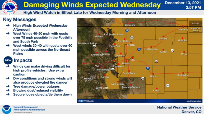
URGENT - WEATHER MESSAGE
National Weather Service Denver CO
231 PM MST Mon Dec 13 2021
COZ035>042-044>051-141215-
/O.CON.KBOU.HW.A.0008.211215T1700Z-211216T0000Z/
Larimer and Boulder Counties Between 6000 and 9000 Feet-
Jefferson and West Douglas Counties Above 6000 Feet/Gilpin/Clear Creek/Northeast Park Counties Below 9000 Feet-
Central and Southeast Park County-
Larimer County Below 6000 Feet/Northwest Weld County-
Boulder And Jefferson Counties Below 6000 Feet/West Broomfield County-North Douglas County Below 6000 Feet/Denver/West Adams and Arapahoe Counties/East Broomfield County-
Elbert/Central and East Douglas Counties Above 6000 Feet-
Northeast Weld County-Morgan County-Central and East Adams and Arapahoe Counties-North and Northeast Elbert County Below 6000 Feet/North Lincoln County-Southeast Elbert County Below 6000 Feet/South Lincoln County-Logan County-Washington County-Sedgwick County-Phillips County-
Including the cities of Wiggins, Fort Morgan, Deer Trail, Hartsel, Karval, Elbert, Westcreek, Hugo, Arvada, Central City, Red Feather Lakes, Julesburg, Larkspur, Agate, Bailey, Leader, Evergreen, Georgetown, Glendevey, Pawnee Buttes, Nederland, Crook, Aurora, Fairplay, Littleton, Amherst, Sterling, Akron, Last Chance, Sedgwick, Raymer, South Park, Byers, Boulder, Highlands Ranch, Cope, City of Denver, Ovid, Matheson, Loveland, Peetz, Kiowa, Grover, Estes Park, Longmont, Fondis, Forder, Kutch, Denver International Airport, Haxtun, Goodrich, Golden, Parker, Castle Rock, Lakewood, Briggsdale, Stoneham, Fort Collins, Bennett, Otis, Punkin Center, Holyoke, Nunn, Idaho Springs, Brush, Lake George, Limon, Hereford, Merino, and Brighton
231 PM MST Mon Dec 13 2021
...HIGH WIND WATCH REMAINS IN EFFECT FROM WEDNESDAY MORNING THROUGH WEDNESDAY AFTERNOON...
* WHAT...West winds 30 to 40 mph with gusts over 60 mph on the plains, and in the foothills 40 to 50 mph with gusts over 75 mph.
* WHERE...Portions of central, east central, north central, and northeast Colorado.
* WHEN...From Wednesday morning through Wednesday afternoon.
* IMPACTS...Damaging winds could blow down trees and power lines. Widespread power outages are possible. Travel could be difficult, especially for high profile vehicles. Blowing dust will reduce visibility to less than a quarter mile in places on the plains.
* ADDITIONAL DETAILS...Strong winds and low humidity will create critical fire weather conditions on the plains.
PRECAUTIONARY/PREPAREDNESS ACTIONS...
Monitor the latest forecasts and warnings for updates.
Fasten loose objects or shelter objects in a safe location prior to the onset of winds.
Winds this strong can make driving difficult, especially for high profile vehicles. Use extra caution.
For more information from the National Weather Service, visit weather.gov/bou
High Wind Warning for December 15, 2021 was created by MountainTownAlerts
URGENT - WEATHER MESSAGE
National Weather Service Denver CO
231 PM MST Mon Dec 13 2021
COZ035>042-044>051-141215-
/O.CON.KBOU.HW.A.0008.211215T1700Z-211216T0000Z/
Larimer and Boulder Counties Between 6000 and 9000 Feet-
Jefferson and West Douglas Counties Above 6000 Feet/Gilpin/Clear Creek/Northeast Park Counties Below 9000 Feet-
Central and Southeast Park County-
Larimer County Below 6000 Feet/Northwest Weld County-
Boulder And Jefferson Counties Below 6000 Feet/West Broomfield County-North Douglas County Below 6000 Feet/Denver/West Adams and Arapahoe Counties/East Broomfield County-
Elbert/Central and East Douglas Counties Above 6000 Feet-
Northeast Weld County-Morgan County-Central and East Adams and Arapahoe Counties-North and Northeast Elbert County Below 6000 Feet/North Lincoln County-Southeast Elbert County Below 6000 Feet/South Lincoln County-Logan County-Washington County-Sedgwick County-Phillips County-
Including the cities of Wiggins, Fort Morgan, Deer Trail, Hartsel, Karval, Elbert, Westcreek, Hugo, Arvada, Central City, Red Feather Lakes, Julesburg, Larkspur, Agate, Bailey, Leader, Evergreen, Georgetown, Glendevey, Pawnee Buttes, Nederland, Crook, Aurora, Fairplay, Littleton, Amherst, Sterling, Akron, Last Chance, Sedgwick, Raymer, South Park, Byers, Boulder, Highlands Ranch, Cope, City of Denver, Ovid, Matheson, Loveland, Peetz, Kiowa, Grover, Estes Park, Longmont, Fondis, Forder, Kutch, Denver International Airport, Haxtun, Goodrich, Golden, Parker, Castle Rock, Lakewood, Briggsdale, Stoneham, Fort Collins, Bennett, Otis, Punkin Center, Holyoke, Nunn, Idaho Springs, Brush, Lake George, Limon, Hereford, Merino, and Brighton
231 PM MST Mon Dec 13 2021
...HIGH WIND WATCH REMAINS IN EFFECT FROM WEDNESDAY MORNING THROUGH WEDNESDAY AFTERNOON...
* WHAT...West winds 30 to 40 mph with gusts over 60 mph on the plains, and in the foothills 40 to 50 mph with gusts over 75 mph.
* WHERE...Portions of central, east central, north central, and northeast Colorado.
* WHEN...From Wednesday morning through Wednesday afternoon.
* IMPACTS...Damaging winds could blow down trees and power lines. Widespread power outages are possible. Travel could be difficult, especially for high profile vehicles. Blowing dust will reduce visibility to less than a quarter mile in places on the plains.
* ADDITIONAL DETAILS...Strong winds and low humidity will create critical fire weather conditions on the plains.
PRECAUTIONARY/PREPAREDNESS ACTIONS...
Monitor the latest forecasts and warnings for updates.
Fasten loose objects or shelter objects in a safe location prior to the onset of winds.
Winds this strong can make driving difficult, especially for high profile vehicles. Use extra caution.
For more information from the National Weather Service, visit weather.gov/bou
Please Log in or Create an account to join the conversation.
- MountainTownAlerts
-
Topic Author
- Mountain Legend
-
Less
More
- Posts: 9766
- Thank you received: 221
14 Dec 2021 08:38 #2
by MountainTownAlerts
Replied by MountainTownAlerts on topic High Wind Warning for December 15, 2021
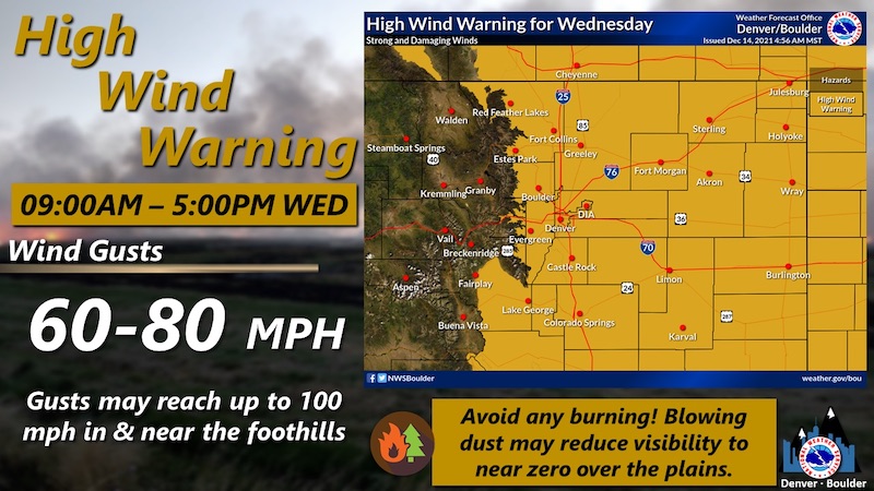
The High Wind Watch is no longer in effect; it has been upgraded to a High Wind Warning.
Mountain town forecasts from our Chief Meteorologist Steve Hamilton: mymountaintown.com/expert-local-weather
High Wind Warning
URGENT - WEATHER MESSAGE
National Weather Service Denver CO
434 AM MST Tue Dec 14 2021
COZ035>039-142215-
/O.UPG.KBOU.HW.A.0008.211215T1700Z-211216T0000Z/
/O.NEW.KBOU.HW.W.0010.211215T1500Z-211216T0000Z/
Larimer and Boulder Counties Between 6000 and 9000 Feet-
Jefferson and West Douglas Counties Above 6000 Feet/Gilpin/Clear Creek/Northeast Park Counties Below 9000 Feet-
Central and Southeast Park County-
Larimer County Below 6000 Feet/Northwest Weld County-
Boulder And Jefferson Counties Below 6000 Feet/West Broomfield County-
Including the cities of Hartsel, Westcreek, Arvada, Central City, Red Feather Lakes, Bailey, Evergreen, Georgetown, Glendevey, Nederland, Fairplay, South Park, Boulder, Loveland, Estes Park, Longmont, Golden, Lakewood, Fort Collins, Nunn, Idaho Springs, Lake George, and Hereford
434 AM MST Tue Dec 14 2021
...HIGH WIND WARNING IN EFFECT FROM 8 AM TO 5 PM MST WEDNESDAY...
* WHAT...West winds 30 to 50 mph with gusts reaching 60 to 80 mph. Wind prone areas in and near the foothills may see gusts near 100 mph.
* WHERE...South Park, Northern and Southern Foothills, Jefferson County, Northwest Weld County, Larimer and Boulder Counties Below 9000 Feet and Broomfield County.
* WHEN...From 8 AM to 5 PM MST Wednesday.
* IMPACTS...Damaging winds may blow down trees and power lines. Widespread power outages will be possible. Travel will be difficult, especially for high profile vehicles. Gusty winds will blow around unsecured objects. Blowing dust will reduce visibility to less than a quarter mile in places.
* ADDITIONAL DETAILS...Strong winds and low humidity will create critical fire weather conditions on the plains.
PRECAUTIONARY/PREPAREDNESS ACTIONS...
Remain in the lower levels of your home during the windstorm, and avoid windows. Watch for falling debris and tree limbs. Use caution if you must drive.
If you encounter blowing dust on the roadway or see it approaching, pull off the road as far as possible and put your vehicle in park. Turn the lights all the way off and keep foot off the brake pedal. Remember, `Pull Aside, Stay Alive`.
Please Log in or Create an account to join the conversation.
- Forum
- Life Up the Hill
- Scanner & Emergency Info, Weather Forecasts
- High Wind Warning for December 15, 2021
Time to create page: 0.169 seconds
sponsors


