Red Flag Warning
URGENT - FIRE WEATHER MESSAGE
National Weather Service Denver/Boulder CO
108 PM MST Mon Dec 20 2021
...CRITICAL FIRE WEATHER CONDITIONS TUESDAY AFTERNOON...
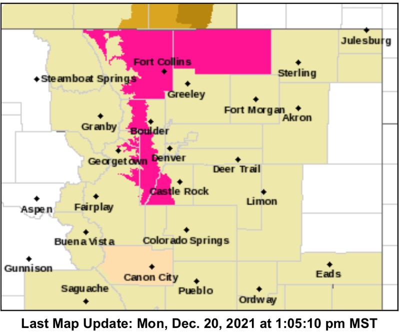
.Very dry and locally breezy conditions will result several hours of critical fire weather conditions Tuesday afternoon for the Cheyenne Ridge, lower elevation foothills, and portions of the Palmer Divide.
COZ215-216-238-242-210415-
/O.NEW.KBOU.FW.W.0026.211221T1600Z-211222T0000Z/
Larimer and Boulder Counties Between 6000 and 9000 Feet-
Jefferson and West Douglas Counties Above 6000 Feet/Gilpin/Clear Creek/Northeast Park Counties Below 9000 Feet-
Larimer County Below 6000 Feet/Northwest Weld County-
Northeast Weld County-
108 PM MST Mon Dec 20 2021
...
RED FLAG WARNING IN EFFECT FROM 9 AM TO 5 PM MST TUESDAY FOR WIND AND LOW RELATIVE HUMIDITY FOR CHEYENNE RIDGE, FOOTHILLS AND PORTIONS OF PALMER DIVIDE...
The National Weather Service in Denver has issued a Red Flag Warning for wind and low relative humidity, which is in effect from 9 AM to 5 PM MST Tuesday.
* Affected Area...Fire Weather Zones 216, 238, and 242, as well as Zone 215 below 7500 ft.
* Timing...10 AM to 5 PM for Zone 215. After 12 PM for all other zones.
* Winds...West 15 to 25 mph with gusts between 30 and 45 mph.
* Relative Humidity...10 to 15%.
* Impacts...Any fires that develop are likely to spread rapidly. Outdoor burning should be avoided, as well as any activities that may cause sparks.
PRECAUTIONARY/PREPAREDNESS ACTIONS...
A Red Flag Warning means that critical fire weather conditions are either occurring now....or will shortly. A combination of strong winds...low relative humidity...and warm temperatures can contribute to extreme fire behavior.