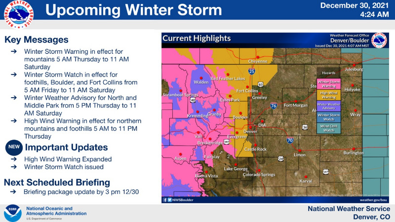
UPDATE: My Mountain Town Weather:
Winter Storm Warning (Red on map)
Winter Weather Advisory (Blue on map)
In effect until 11:00 a.m. Saturday
Snow is likely in the Warning and Advisory areas.
Heavy snow is occasionally possible.
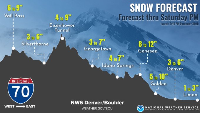
Warning area: 5 to 10" possible with up to 1 foot possible in the higher terrain.
Advisory area: 2 to 6" possible. Locally higher amounts.
Prepare for difficult travel, icy and snow packed roads, poor visibility and blowing snow.
mymountaintown.com/expert-local-weather
URGENT - WINTER WEATHER MESSAGE
National Weather Service Denver CO
157 PM MST Thu Dec 30 2021
COZ035-036-038-039-310500-
/O.UPG.KBOU.WS.A.0011.211231T1200Z-220101T1800Z/
/O.EXB.KBOU.WS.W.0013.211231T1200Z-220101T1800Z/
Larimer and Boulder Counties Between 6000 and 9000 Feet-Jefferson and West Douglas Counties Above 6000 Feet/Gilpin/Clear Creek/Northeast Park Counties Below 9000 Feet-
Larimer County Below 6000 Feet/Northwest Weld County-
Boulder And Jefferson Counties Below 6000 Feet/West Broomfield County-
Including the cities of Evergreen, Georgetown, Glendevey,
Lakewood, Nederland,
Golden, Fort Collins, Westcreek, Longmont,
Arvada, Loveland, Central City, Red Feather Lakes, Nunn,
Idaho Springs, Estes Park,
Bailey, Hereford, and Boulder
157 PM MST Thu Dec 30 2021
...
WINTER STORM WARNING IN EFFECT FROM 5 AM FRIDAY TO 11 AM MST SATURDAY...
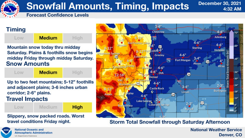
* WHAT...Heavy snow likely.
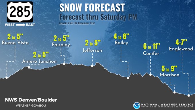
Total snow accumulations between 5 and 10 inches expected. Higher amounts to 1 foot possible for higher terrain in the foothills and near Estes Park.
* WHERE...The Northern Front Range Foothills, The Southern Front Range Foothills, Fort Collins, and Boulder and the western suburbs of Denver.
* WHEN...From 5 AM Friday to 11 AM MST Saturday.
* IMPACTS...Travel could be very difficult. The hazardous conditions could impact the Friday morning and evening commutes.
PRECAUTIONARY/PREPAREDNESS ACTIONS...
If you must travel, keep an extra flashlight, food, and water in your vehicle in case of an emergency. The latest road conditions for Colorado can be obtained by calling 5 1 1 or by going to
www.cotrip.org