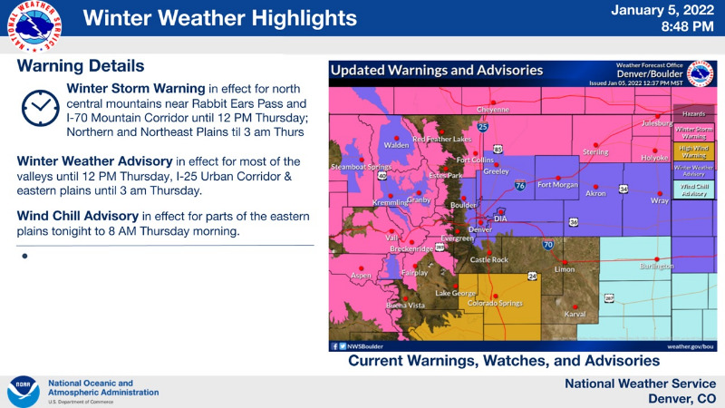
Winter Storm Warning
URGENT - WINTER WEATHER MESSAGE
National Weather Service Denver CO
902 PM MST Wed Jan 5 2022
COZ034-061215-
/O.CON.KBOU.WS.W.0001.000000T0000Z-220106T1900Z/
South and Southeast Grand/West Central and Southwest Boulder/Gilpin/
Clear Creek/Summit/North and West Park Counties Above 9000 Feet-
Including the cities of Indian Peaks, Eisenhower Tunnel, East Slopes Southern Gore Range, Mount Evans, East Slopes Mosquito Range, Breckenridge, Winter Park, Williams Fork Mountains, Kenosha Mountains, and Berthoud Pass
902 PM MST Wed Jan 5 2022
...
WINTER STORM WARNING REMAINS IN EFFECT UNTIL NOON MST THURSDAY...
* WHAT...
Heavy snow expected. Total snow accumulations between 8 and 18 inches. Winds could gust as high as 60 mph with blowing snow and poor visibilities over the mountain passes and exposed ridges.
* WHERE...The Mountains of Summit County, the Mosquito Range, and the Indian Peaks.
* WHEN...Until Noon MST Thursday.
* IMPACTS...Travel could be very difficult. Widespread blowing snow could significantly reduce visibility. The hazardous conditions could impact the Thursday morning commute. Gusty winds could bring down tree branches.
PRECAUTIONARY/PREPAREDNESS ACTIONS...
If you must travel, keep an extra flashlight, food, and water in your vehicle in case of an emergency. The latest road conditions for Colorado can be obtained by calling 5 1 1 or by going to
www.cotrip.org
_ _ _ _ _ _ _ _ _ _ _ _ _
Winter Weather Advisory
URGENT - WINTER WEATHER MESSAGE
National Weather Service Denver/Boulder CO
912 PM MST Wed Jan 5 2022
COZ039-040-043-045-061215-
/O.EXA.KBOU.WC.Y.0002.000000T0000Z-220106T1500Z/
/O.CON.KBOU.WW.Y.0001.000000T0000Z-220106T1000Z/
Boulder And Jefferson Counties Below 6000 Feet/West Broomfield County-
North Douglas County Below 6000 Feet/Denver/West Adams and Arapahoe Counties/East Broomfield County-
Central and South Weld County-
Central and East Adams and Arapahoe Counties-
Including Arvada, Boulder, Golden, Lakewood, Longmont, Aurora, Brighton,
City of Denver, Denver International Airport, Highlands Ranch,
Littleton, Parker, Eaton, Fort Lupton, Greeley, Roggen, Bennett, Byers, Deer Trail, and Leader
912 PM MST Wed Jan 5 2022
...
WIND CHILL ADVISORY IN EFFECT UNTIL 8 AM MST THURSDAY...
...WINTER WEATHER ADVISORY REMAINS IN EFFECT UNTIL 3 AM MST THURSDAY...
* WHAT...
For the Winter Weather Advisory, snow. Additional snow accumulations of up to two inches. For the Wind Chill Advisory, very cold wind chills. Wind chills as low as 20 below zero.
* WHERE...Boulder and the western suburbs of Denver, Denver, Central and Southern Weld County and Eastern Adams and Arapahoe Counties.
* WHEN...For the Wind Chill Advisory, until 8 AM MST Thursday. For the Winter Weather Advisory, until 3 AM MST Thursday.
* IMPACTS...Exposed skin may become quickly frostbitten or frozen. Plan on slippery road conditions. The dangerously cold wind chills could cause frostbite on exposed skin in as little as 30 minutes. Roads will likely become slick and hazardous.
PRECAUTIONARY/PREPAREDNESS ACTIONS...
Slow down and use caution while traveling.
Use caution while traveling outside. Wear appropriate clothing, a hat, and gloves.
The latest road conditions for the state you are calling from can be obtained by calling 5 1 1.