From Chief Meteorologist Steve Hamilton:
mymountaintown.com/expert-local-weather
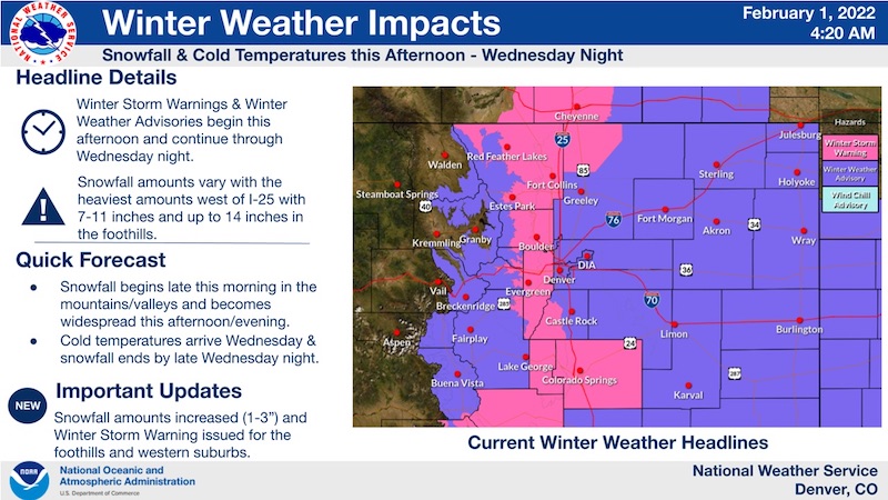
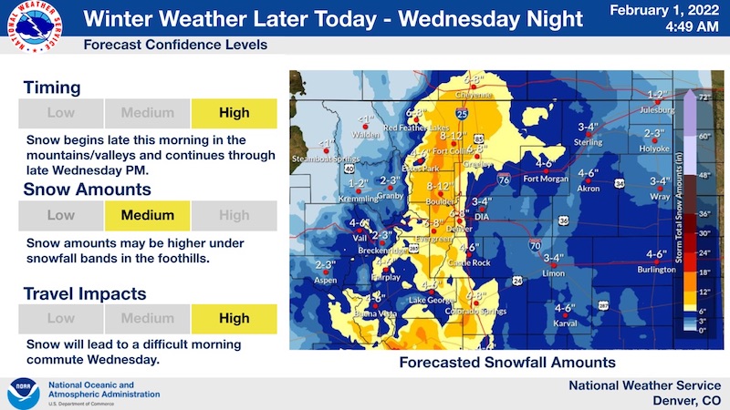
It's looking like we have a good chance of accumulating snow between Tuesday afternoon and Wednesday night. Two key weather systems will affect the Foothills. Strong low pressure will develop in the Southern Plains and also Southern Colorado. And, an Arctic cold front will drop into Eastern Colorado, bringing very cold temperatures. Models are showing good agreement on accumulating snowfall, thanks to a strong upper level jet stream pattern, and increasing moisture in the mid-levels of the atmosphere. We should get enough lift and upslope flow for accumulations between 4 and 10 inches across the Foothills by late Wednesday. Prepare for slow travel, snow-packed and slick roads and poor visibility. Make sure your gas tank and washer fluid are full, and your wipers are in good shape if you are venturing out. Additionally, temperatures will be cold Tuesday night through Wednesday night, with many locations dropping below zero.
Winter Storm Warning
URGENT - WINTER WEATHER MESSAGE
National Weather Service Denver CO
323 AM MST Tue Feb 1 2022
...COLD AND SNOW MOVING IN THIS AFTERNOON AND CONTINUING THROUGH
WEDNESDAY...
.An extended period of snow, colder temperatures, and slick and
hazardous travel conditions can be expected, starting late this
afternoon and evening.
A slow moving storm system will move into the area later today and
remain over the area through Wednesday. In addition, a series of
cold fronts will push across the plains ushering in much colder
temperatures. Snow will first develop over the mountains and
foothills this afternoon and then spread east across the I-25
Corridor in the late afternoon and early evening. Snow continues to
spread eastward over the eastern plains later this evening. The snow
will continue through Wednesday before coming to an end Wednesday
night.
For the latest road conditions, go to cotrip.org or dial 511.
COZ035-036-012300-
/O.CON.KBOU.WS.W.0002.220201T2100Z-220203T0700Z/
Larimer and Boulder Counties Between 6000 and 9000 Feet-
Jefferson and West Douglas Counties Above 6000 Feet/Gilpin/Clear Creek/Northeast Park Counties Below 9000 Feet-
Including the cities of Evergreen, Georgetown, Glendevey, Nederland, Westcreek, Central City, Red Feather Lakes,
Idaho Springs, Estes Park, and
Bailey
323 AM MST Tue Feb 1 2022
...
WINTER STORM WARNING REMAINS IN EFFECT FROM 2 PM THIS AFTERNOON TO MIDNIGHT MST WEDNESDAY NIGHT...
* WHAT...Snow expected.
Total snow accumulations 7 to 14 inches. Winds gusting up to 30 mph.
* WHERE...The Front Range Foothills.
* WHEN...From 2 PM this afternoon to Midnight MST Wednesday Night.
* IMPACTS...Snow covered roads will make travel hazardous. Travel may become very difficult due to heavy snowfall on roadways.
PRECAUTIONARY/PREPAREDNESS ACTIONS...
Roads will be slick resulting in slow and hazardous travel. Allow extra time to reach your destination.
Consider altering your travel plans. Heavy snowfall is expected to make travel very difficult to impossible.
Expected snowfall: