- Posts: 9766
- Thank you received: 221
- Forum
- Life Up the Hill
- Scanner & Emergency Info, Weather Forecasts
- Winter Storm Warning February 16, 2022
Winter Storm Warning February 16, 2022
- MountainTownAlerts
-
 Topic Author
- Mountain Legend
-

Less
More
15 Feb 2022 15:06 #1
by MountainTownAlerts
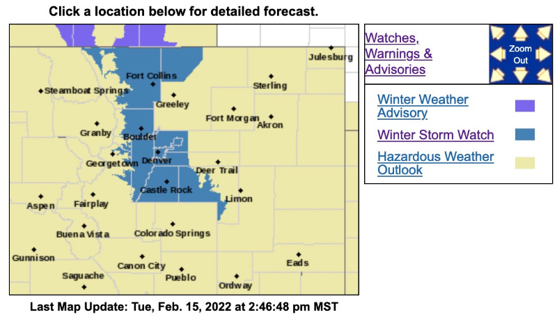
Winter Storm Watch
URGENT - WINTER WEATHER MESSAGE
National Weather Service Denver CO
210 PM MST Tue Feb 15 2022
...SNOW IS EXPECTED TO IMPACT THE AFTERNOON AND EVENING COMMUTE...
.Snow will return to the mountains midday Wednesday, and spread from north to south throughout the afternoon, reaching the plains by early to mid afternoon. Roads will initially remain wet but closer to sunset they should become slick and snow covered. The heaviest snow is expected to fall between 4-8 PM.
COZ035-036-038>041-161215-
/O.EXT.KBOU.WS.A.0002.220216T2100Z-220217T1200Z/
Larimer and Boulder Counties Between 6000 and 9000 Feet-
Jefferson and West Douglas Counties Above 6000 Feet/Gilpin/Clear Creek/Northeast Park Counties Below 9000 Feet-
Larimer County Below 6000 Feet/Northwest Weld County-
Boulder And Jefferson Counties Below 6000 Feet/West Broomfield County-
North Douglas County Below 6000 Feet/Denver/West Adams and Arapahoe Counties/East Broomfield County-
Elbert/Central and East Douglas Counties Above 6000 Feet-
Including the cities of Elbert, Westcreek, Arvada, Central City, Red Feather Lakes, Larkspur, Bailey, Evergreen, Georgetown, Glendevey, City of Denver, Aurora, Littleton, Brighton, Boulder, Highlands Ranch, Loveland, Kiowa, Estes Park, Longmont, Fondis, Denver International Airport, Golden, Parker, Castle Rock, Lakewood, Fort Collins, Nunn, Idaho Springs, Hereford, and Nederland
210 PM MST Tue Feb 15 2022
...WINTER STORM WATCH NOW IN EFFECT FROM WEDNESDAY AFTERNOON THROUGH LATE WEDNESDAY NIGHT...
* WHAT...Heavy snow possible. Total snow accumulations between 4 and 8 inches possible. Winds could gust as high as 35 mph.
* WHERE...Portions of central, north central, and northeast Colorado.
* WHEN...From Wednesday afternoon through late Wednesday night.
* IMPACTS...Plan on slippery road conditions. The hazardous conditions will impact the Wednesday evening and Thursday morning commutes.
PRECAUTIONARY/PREPAREDNESS ACTIONS...
Monitor the latest forecasts for updates on this situation.
For more information from the National Weather Service, visit weather.gov/bou
Winter Storm Warning February 16, 2022 was created by MountainTownAlerts
Winter Storm Watch
URGENT - WINTER WEATHER MESSAGE
National Weather Service Denver CO
210 PM MST Tue Feb 15 2022
...SNOW IS EXPECTED TO IMPACT THE AFTERNOON AND EVENING COMMUTE...
.Snow will return to the mountains midday Wednesday, and spread from north to south throughout the afternoon, reaching the plains by early to mid afternoon. Roads will initially remain wet but closer to sunset they should become slick and snow covered. The heaviest snow is expected to fall between 4-8 PM.
COZ035-036-038>041-161215-
/O.EXT.KBOU.WS.A.0002.220216T2100Z-220217T1200Z/
Larimer and Boulder Counties Between 6000 and 9000 Feet-
Jefferson and West Douglas Counties Above 6000 Feet/Gilpin/Clear Creek/Northeast Park Counties Below 9000 Feet-
Larimer County Below 6000 Feet/Northwest Weld County-
Boulder And Jefferson Counties Below 6000 Feet/West Broomfield County-
North Douglas County Below 6000 Feet/Denver/West Adams and Arapahoe Counties/East Broomfield County-
Elbert/Central and East Douglas Counties Above 6000 Feet-
Including the cities of Elbert, Westcreek, Arvada, Central City, Red Feather Lakes, Larkspur, Bailey, Evergreen, Georgetown, Glendevey, City of Denver, Aurora, Littleton, Brighton, Boulder, Highlands Ranch, Loveland, Kiowa, Estes Park, Longmont, Fondis, Denver International Airport, Golden, Parker, Castle Rock, Lakewood, Fort Collins, Nunn, Idaho Springs, Hereford, and Nederland
210 PM MST Tue Feb 15 2022
...WINTER STORM WATCH NOW IN EFFECT FROM WEDNESDAY AFTERNOON THROUGH LATE WEDNESDAY NIGHT...
* WHAT...Heavy snow possible. Total snow accumulations between 4 and 8 inches possible. Winds could gust as high as 35 mph.
* WHERE...Portions of central, north central, and northeast Colorado.
* WHEN...From Wednesday afternoon through late Wednesday night.
* IMPACTS...Plan on slippery road conditions. The hazardous conditions will impact the Wednesday evening and Thursday morning commutes.
PRECAUTIONARY/PREPAREDNESS ACTIONS...
Monitor the latest forecasts for updates on this situation.
For more information from the National Weather Service, visit weather.gov/bou
Please Log in or Create an account to join the conversation.
- MountainTownAlerts
-
Topic Author
- Mountain Legend
-
Less
More
- Posts: 9766
- Thank you received: 221
15 Feb 2022 18:08 #2
by MountainTownAlerts
Replied by MountainTownAlerts on topic Winter Storm Warning February 16, 2022
From US National Weather Service Denver/Boulder Colorado
11m
11m
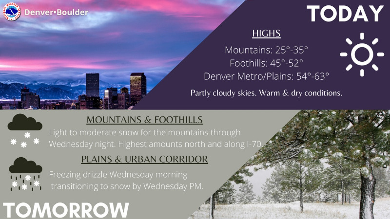
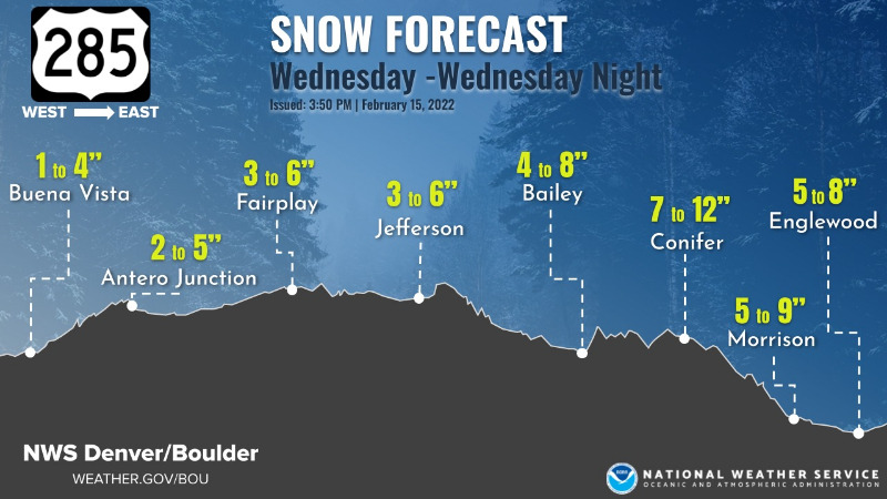
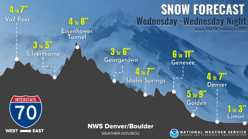
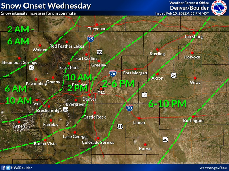
The ever popular intestate and higway snowfall forecasts. Also, we've included a tming graphic (please see additional images) of when the snow is expected to start. The heaviest will likely occur in the evening, with travel impacts expected for the pm rush in/near the foothills & I-25 Corridor. Plan ahead.
Please Log in or Create an account to join the conversation.
- MountainTownAlerts
-
Topic Author
- Mountain Legend
-
Less
More
- Posts: 9766
- Thank you received: 221
16 Feb 2022 08:32 #3
by MountainTownAlerts
Replied by MountainTownAlerts on topic Winter Storm Warning February 16, 2022
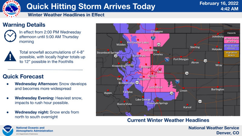
The Winter Storm Watch has been upgraded to a Winter Storm Warning.
Winter Storm Warning
URGENT - WINTER WEATHER MESSAGE
National Weather Service Denver CO
332 AM MST Wed Feb 16 2022
...SNOW IS EXPECTED TO IMPACT THE AFTERNOON AND EVENING COMMUTE TODAY. ...
.Snow will return to the mountains this morning, and then spread from northwest to southeast across the foothills and I-25 Corridor through the afternoon. The eastern plains will see snow develop late in the afternoon and evening. Roads will initially remain wet, but closer to sunset they should become slick and snow covered. The heaviest snow is expected to fall between 5 and 9 PM.
COZ035-036-038>041-161845-
/O.UPG.KBOU.WS.A.0002.220216T2100Z-220217T1200Z/
/O.NEW.KBOU.WS.W.0003.220216T2100Z-220217T1200Z/
Larimer and Boulder Counties Between 6000 and 9000 Feet-
Jefferson and West Douglas Counties Above 6000 Feet/Gilpin/Clear Creek/Northeast Park Counties Below 9000 Feet-
Larimer County Below 6000 Feet/Northwest Weld County-
Boulder And Jefferson Counties Below 6000 Feet/West Broomfield County-
North Douglas County Below 6000 Feet/Denver/West Adams and Arapahoe Counties/East Broomfield County-
Elbert/Central and East Douglas Counties Above 6000 Feet-
Including the cities of Elbert, Westcreek, Arvada, Central City, Red Feather Lakes, Larkspur, Bailey, Evergreen, Georgetown, Glendevey, City of Denver, Aurora, Littleton, Brighton, Boulder, Highlands Ranch, Loveland, Kiowa, Estes Park, Longmont, Fondis, Denver International Airport, Golden, Parker, Castle Rock, Lakewood, Fort Collins, Nunn, Idaho Springs, Hereford, and Nederland
332 AM MST Wed Feb 16 2022
...WINTER STORM WARNING IN EFFECT FROM 2 PM THIS AFTERNOON TO 5 AM MST THURSDAY...
* WHAT...Heavy snow possible. Total snow accumulations between 4 and 8 inches possible, with 6 to 12 inches in the foothills.
* WHERE...Portions of central, north central, and northeast Colorado.
* WHEN...From 2 PM this afternoon to 5 AM MST Thursday.
* IMPACTS...Travel could be difficult. The hazardous conditions could impact the Wednesday evening commute.
PRECAUTIONARY/PREPAREDNESS ACTIONS...
If you must travel, keep an extra flashlight, food, and water in your vehicle in case of an emergency. The latest road conditions for Colorado can be obtained by calling 5 1 1 or by going to www.cotrip.org
_ _ _ _ _ _ _ _ _ _ _ _ _ _ _ _ _ _ _ _ _ _ _ _ _ _ _ _ _ _ _ _ _ _ _ _ _ _ _ _ _ _ _ _ _
Winter Weather Advisory
URGENT - WINTER WEATHER MESSAGE
National Weather Service Denver CO
332 AM MST Wed Feb 16 2022
COZ033-034-161845-
/O.NEW.KBOU.WW.Y.0010.220216T2100Z-220217T1200Z/
South and East Jackson/Larimer/North and Northeast Grand/Northwest Boulder Counties Above 9000 Feet-
South and Southeast Grand/West Central and Southwest Boulder/Gilpin/Clear Creek/Summit/North and West Park Counties Above 9000 Feet-
Including the cities of East Slopes Mosquito Range, Indian Peaks, Eisenhower Tunnel, Rocky Mountain National Park, East Slopes Southern Gore Range, Mount Evans, Laramie and Medicine Bow Mountains, Cameron Pass, Breckenridge, Kenosha Mountains, Winter Park, Williams Fork Mountains, Willow Creek Pass, Rabbit Ears Range, and Berthoud Pass
332 AM MST Wed Feb 16 2022
...WINTER WEATHER ADVISORY IN EFFECT FROM 2 PM THIS AFTERNOON TO 5 AM MST THURSDAY...
* WHAT...Snow expected. Total snow accumulations between 5 and 10 inches with the highest amounts on east facing slopes.
* WHERE...Rocky Mountain National Park and the Medicine Bow Range, and The Mountains of Summit County, the Mosquito Range, and the Indian Peaks.
* WHEN...From 2 PM this afternoon to 5 AM MST Thursday.
* IMPACTS...Travel could be difficult. The hazardous conditions could impact the Wednesday evening commute.
PRECAUTIONARY/PREPAREDNESS ACTIONS...
Slow down and use caution while traveling. The latest road conditions for Colorado can be obtained by calling 5 1 1 or by going to www.cotrip.org
For more information from the National Weather Service, visit weather.gov/bou
Please Log in or Create an account to join the conversation.
- Forum
- Life Up the Hill
- Scanner & Emergency Info, Weather Forecasts
- Winter Storm Warning February 16, 2022
Time to create page: 0.225 seconds
sponsors


