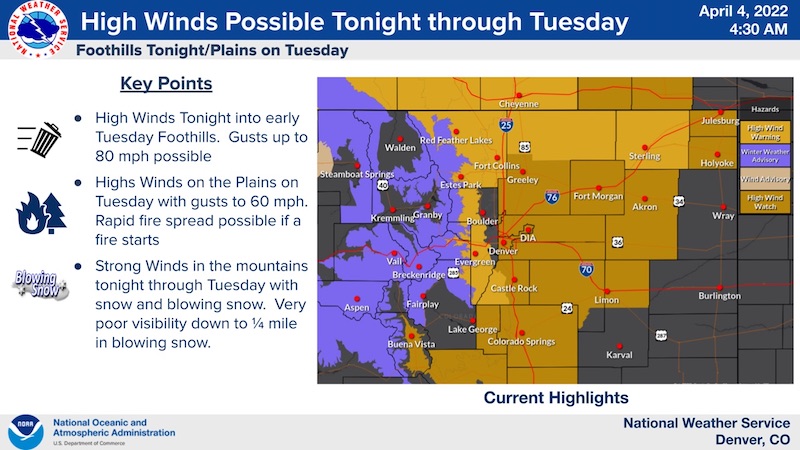
High Wind Warning
URGENT - WEATHER MESSAGE
National Weather Service Denver CO
408 AM MDT Mon Apr 4 2022
COZ035-036-041815-
/O.NEW.KBOU.HW.W.0005.220405T0000Z-220405T1500Z/
Larimer and Boulder Counties Between 6000 and 9000 Feet-
Jefferson and West Douglas Counties Above 6000 Feet/Gilpin/Clear Creek/Northeast Park Counties Below 9000 Feet-
Including the cities of Evergreen, Georgetown, Glendevey, Nederland, Westcreek, Central City, Red Feather Lakes, Idaho Springs, Estes Park, and Bailey
408 AM MDT Mon Apr 4 2022
...
HIGH WIND WARNING IN EFFECT FROM 6 PM THIS EVENING TO 9 AM MDT TUESDAY...
* WHAT...West winds 30 to 40 mph with gusts up to 80 mph expected.
* WHERE...The Northern Front Range Foothills, and The Southern Front Range Foothills.
* WHEN...From 6 PM this evening to 9 AM MDT Tuesday.
* IMPACTS...Damaging winds will blow down trees and power lines. Widespread power outages are expected. Travel will be difficult, especially for high profile vehicles.
PRECAUTIONARY/PREPAREDNESS ACTIONS...
Remain in the lower levels of your home during the windstorm, and avoid windows. Watch for falling debris and tree limbs. Use caution if you must drive.
_ _ _ _ _ _ _ _ _
Winter Weather Advisory
URGENT - WINTER WEATHER MESSAGE
National Weather Service Denver CO
405 AM MDT Mon Apr 4 2022
COZ031-033-034-041815-
/O.NEW.KBOU.WW.Y.0019.220405T0300Z-220406T0600Z/
West Jackson and West Grand Counties Above 9000 Feet-South and East Jackson/Larimer/North and Northeast Grand/Northwest Boulder Counties Above 9000 Feet-
South and Southeast Grand/West Central and Southwest Boulder/Gilpin/
Clear Creek/Summit/North and West Park Counties Above 9000 Feet-
Including the cities of East Slopes Mosquito Range, Indian Peaks, Eisenhower Tunnel, Rocky Mountain National Park, East Slopes Southern Gore Range, Mt Zirkel,
Mount Evans, Laramie and Medicine Bow Mountains, Cameron Pass,
Breckenridge, Kenosha Mountains, Winter Park, Williams Fork Mountains, Willow Creek Pass, Rabbit Ears Range, and Berthoud Pass
405 AM MDT Mon Apr 4 2022
...
WINTER WEATHER ADVISORY IN EFFECT FROM 9 PM THIS EVENING TO MIDNIGHT MDT TUESDAY NIGHT...
* WHAT...Snow expected.
Total snow accumulations from 5 to 10 inches. Winds gusting as high as 70 mph with very poor visibility in blowing snow.
* WHERE...Rabbit Ears Pass, Rocky Mountain National Park and the Medicine Bow Range, and The Mountains of Summit County, the Mosquito Range, and the Indian Peaks.
* WHEN...From 9 PM this evening to Midnight MDT Tuesday Night.
* IMPACTS...Snow and blowing snow will reduce visibility to a quarter mile or less. Travel could be very difficult. Widespread blowing snow could significantly reduce visibility. The hazardous conditions could impact the Tuesday morning and evening commutes. Gusty winds could bring down tree branches.
PRECAUTIONARY/PREPAREDNESS ACTIONS...
Slow down and use caution while traveling. The latest road conditions for Colorado can be obtained by calling 5 1 1 or by going to
www.cotrip.org
.
For more information from the National Weather Service, visit
weather.gov/bou