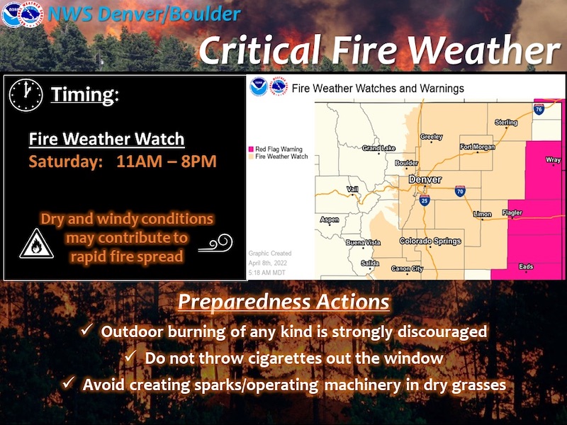
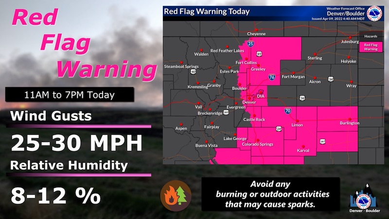
The Fire Weather Watch has been upgraded to a Red Flag Warning for today. A Fire Weather Watch is now in effect for tomorrow, Sunday April 10.
Red Flag Warning
URGENT - FIRE WEATHER MESSAGE
National Weather Service Denver/Boulder CO
444 AM MDT Sat Apr 9 2022
...Locally critical fire weather conditions Saturday and Sunday afternoon...
Very dry conditions combined with breezy winds are expected to lead to critical fire weather conditions across much of the urban corridor, Palmer Divide, Cheyenne Ridge and southern plains Saturday afternoon. Pockets of critical conditions may also occur into the eastern plains.
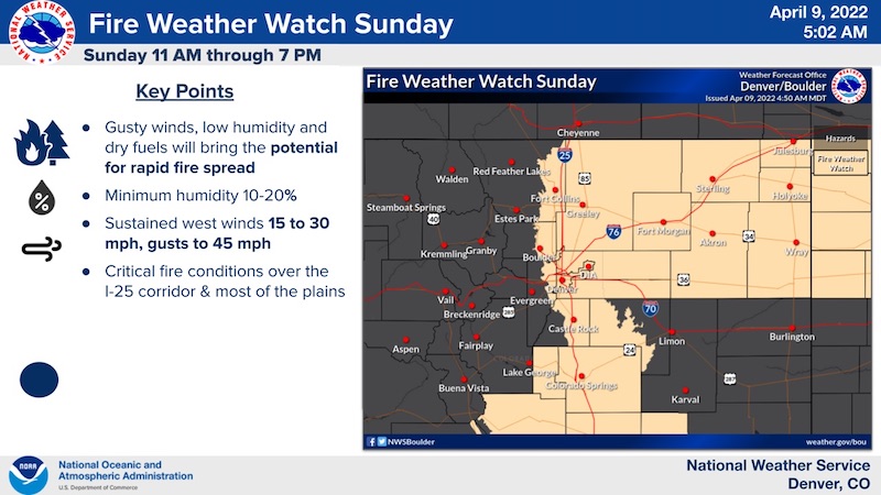
Wind gusts will be stronger on Sunday as the dry conditions continue. This may create to critical fire weather conditions across portions of the plains.
COZ238>243-091845-
/O.NEW.KBOU.FW.A.0006.220410T1700Z-220411T0100Z/
/O.CON.KBOU.FW.W.0007.220409T1700Z-220410T0100Z/
Larimer County Below 6000 Feet/Northwest Weld County-
Boulder And Jefferson Counties Below 6000 Feet/West Broomfield County-
North Douglas County Below 6000 Feet/Denver/West Adams and
Arapahoe Counties/East Broomfield County-
Elbert/Central and East Douglas Counties Above 6000 Feet-
Northeast Weld County-Central and South Weld County-
444 AM MDT Sat Apr 9 2022
...
RED FLAG WARNING REMAINS IN EFFECT FROM 11 AM THIS MORNING TO 7 PM MDT THIS EVENING FOR WIND AND LOW RELATIVE HUMIDITY FOR THE I-25 CORRIDOR AND PORTIONS OF THE PLAINS...
...FIRE WEATHER WATCH IN EFFECT FROM SUNDAY MORNING THROUGH SUNDAY EVENING FOR WIND AND LOW RELATIVE HUMIDITY FOR THE I-25 CORRIDOR AND PORTIONS OF THE PLAINS...
The National Weather Service in Denver has issued a Fire Weather Watch for wind and low relative humidity, which is in effect from Sunday morning through Sunday evening.
* Affected Area...Fire Weather Zones 238, 239, 240, 241, 242 and 243.
* Timing...11 AM MDT until 7 PM MDT today and Sunday.
* Winds...West 10 to 20 mph with gusts to 30 mph today. Northwest 20 to 30 mph with gusts up to 45 mph on Sunday.
* Relative Humidity...As low as 11 percent.
* Impacts...Any fire that develops will likely spread rapidly. Outdoor burning should be avoided, as well as any activity that may produce a spark and start a fast moving wildfire.
PRECAUTIONARY/PREPAREDNESS ACTIONS...
A Red Flag Warning means that critical fire weather conditions are either occurring now....or will shortly. A combination of strong winds...low relative humidity...and warm temperatures can contribute to extreme fire behavior.
A Fire Weather Watch means that critical fire weather conditions are forecast to occur. Listen for later forecasts and possible Red Flag Warnings.
_ _ _ _ _ _ _ _ _ _ _ _ _ _ _ _ _ _ _ _ _ _ _ _ _ _ _ _ _ _ _ _ _ _ _ _ _ _ _ _ _ _
Sunday April 10, 2022 - Fire Weather Watch